Bridge restaurant

Last updated

A bridge restaurant or restaurant bridge is a restaurant, usually indoors, built like a bridge over a road, mostly over freeways or motorways. It usually provides access from both sides of the road without the need of crossing the road by tunnel or footbridge. The construction also attracts the attention of motorists, making it easy to find the rest area.

Contents

The world's first bridge restaurant, built in 1957 in Vinita, Oklahoma (2008) McDonalds on Interstate 44.jpg
The world's first bridge restaurant, built in 1957 in Vinita, Oklahoma (2008)
Europe's first bridge restaurant, built in 1959 in Fiorenzuola d'Arda, Italy Autogrill Arda dir. ovest.jpg
Europe's first bridge restaurant, built in 1959 in Fiorenzuola d'Arda, Italy

Motorways

United States

The first bridge restaurant was built in 1957, over I-44 (Will Rogers Turnpike) [1] at the Vinita, Oklahoma, rest area. It is currently a McDonald's, Subway fast-food restaurant, and a Kum & Go gas station and was the world's largest until the opening of a larger location in Moscow, Russia. With the construction of the Illinois Tollway in 1958, five more bridge restaurants were built as Illinois Tollway Oases, opening in 1959. Further implementation of the concept in the United States has been hampered by US Code 23 Section 111, which prohibits commercial activities at the rest areas along the Interstate Highways. Although commercial activities existing before 1960 could continue and the unaffected turnpikes already had commercialized rest areas, no new restaurants were added. Despite this legislation, the Lincoln Oasis bridge restaurant has been opened in 1967.

Italy

The concept was introduced to Europe in 1959 by the Italian architect Angelo Bianchetti, [2] who built the first European bridge restaurant in slightly more than six months. In 1962, Pavesi replaced its existing roadside restaurants at Novara and Bergamo along the Autostrada Serenissima by bridge restaurants at Novara and Osio. This was done in conjunction with the upgrade of the three-lane highway to motorway standards. Bianchetti built nine bridge restaurants for his principal, the Italian food chain Pavesi. Three Pavesi bridges, Chianti, Dorno and Serrevalle-Pistoiese, were built by other architects. The concept was replicated by Pavesi's competitor Motta, who built two bridges at the Cantagallo [3] and Limena [4] rest areas and later on spread over Europe. In 1974 the Italian chains were heavily affected by the oil crisis and as a result, no more bridge restaurants were built in Italy. In 2012 there are 13 bridge restaurants left in Italy. In 2021 the most daring Autogrill in the world (Montepulciano) was demolished due to structural problems after 50 years of service.

Rest of Europe

Inspired by the Italian example, the concept spread over Europe along with the expansion of motorway networks. Britain's first motorway, the M6 was equipped with motorway service areas (MSA). In contrast to the United States, commercialized rest areas along state-owned motorways are common in Europe. Many of the British MSAs have footbridges for crossing the motorway but only five MSAs were built as bridge restaurants, all in the early 1960s. The M6 got three of them, the fourth was built at Farthing Corner (today Medway) over the M2 and the last at Leicester Forest East over the M1 which opened in 1966. The building of bridge restaurants in Britain stopped because of the fire risks because they were regarded as an obstacle for road widening in the future and because of the finding that drivers do not find any rest when they are still watching the traffic.[ citation needed ]

In Germany, there are two MSAs built as bridge restaurants. The first opened in 1967 at the Rudolphstein/Hirschberg crossing of the inner German border along the Berlin Munich transit route. Visitors had a view of the iron curtain from the restaurant. The second was built at the Dammer Berge MSA over the A 1 at Holdorf in 1969. Building bridge restaurants in Germany was more expensive than two restaurants at both roadsides. Because of the length of the bridges, many facilities, such as toilets, kitchens, and storage rooms had to be built twice on a bridge, so it turned out that it was too expensive to build further bridge restaurants over the Autobahn. [5] In Belgium the concept is widespread and still applied for new MSAs. At the beginning of the 1970s, Jacques Borel introduced the bridge restaurant to France, and Mövenpick followed soon in Switzerland. The Netherlands followed in 1980 with Rick's, situated at Den Ruygen Hoek MSA near Schiphol. Scandinavia got its first bridge restaurant in the mid-1980s.

Other roads

There are also bridge restaurants beside the motorways. In Oldenzaal (Netherlands) and Berlin (Germany) they are built across broad lanes. The Haus der Deutschen Weinstraße is built over a two-lane road with, as an exception, an entrance at only one roadside. The smallest bridge restaurant is situated in Kufstein (Austria), where a 15th-century service bridge across a street in the old city has been redeveloped to a bridge restaurant with two seats.

Construction

The bridge restaurants in the United States are, except the Lincoln Oasis, more or less replications of the same design based upon a tied-arch bridge. The Lincoln Oasis, [6] designed by David Haid, used a steel frame combined with a glass facade derived from the Italian MSAs at Arda and Cantagallo. The Illinois oasis were renovated in 2003 and have all got a similar look since.

The European bridge restaurants are mostly unique designs. The bridge restaurant should be a landmark and they were designed for their specific operator and location.

Steel frame

The first two Italian bridge restaurants at Fiorenzuola d'Arda and Cantagallo [7] both got reinforced concrete entry buildings that serve as supports for the steel frame span crossing the carriageways. The bridge restaurant at Cantagallo was destroyed by fire in 1981 and rebuilt as a reinforced concrete bridge.

Concrete

In 1961 reinforced concrete was introduced for the span itself. Bianchetti designed a reinforced concrete bridge restaurant [8] for the Novara MSA in 1962. Afterward, this design was almost completely copied at Osio MSA, today Brembo. The two in Tuscany, at Serrevalle Pistoiese MSA and Chianti MSA, and the one at Dorno MSA were designed by other architects resulting in unique designs at the different sites. The British bridge restaurants are all built with reinforced concrete and all specially designed for the specific location. In 1963 and 1964 Bianchetti built two specially designed bridge restaurants at the south (Frascati) and north (Feronia) of Rome. [9] Architect Carlo Casati introduced prestressed concrete in his design at Dorno MSA in 1964. [10] A unique design was built by Bega and Nervi at the Limena MSA in 1967. [11] The span has been built as a concrete box with octagonal windows in the walls. In 1969 the German architects Paul Wolters and Manfred Bock combined a prestressed concrete deck with a steel frame top at Dammer Berge MSA.

Double deck

Bianchetti's next step was the double-deck bridge restaurant with one floor for the restaurant and the other for shops. At Montepulciano, he used the steel frame technique, already implemented at Arda and Cantagallo. The whole design is exceptional because of its cantilever construction that can be seen from the outside. [12] The last bridge restaurant design of Bianchetti is a double-deck concrete bridge that was built at Soave MSA in 1969, just east of Verona and at Alfaterna MSA in 1971, just south of Nocera Inferiore. The upper level at Alfaterna [13] was used as a motel, but this bridge has been demolished. In Switzerland both Würenlos MSA in 1972 and Knonauer Amt MSA in 2009, got a double-deck bridge restaurant as well.

Other restaurants

Würenlos and Nyköpingsbro are built as cable-stayed bridge. The bridge restaurant in Pratteln, designed by Casoni & Casoni from Basle, is unique for its fiberglass facade. In Scandinavia and Illinois the parking lots are at the same level as the bridge. Except for Frascati, Ayer Keroh, and Petroport, the other bridge restaurants have an entrance on street-level from which the customers enter the bridge by stairs, escalator or elevator.

List

Rest areaCountryHighwayOpenedCoordinates
Auracher Löchl Flag of Austria.svg  Austria Römerhofgasse, Kufstein 47°34′56″N12°10′5.8″E / 47.58222°N 12.168278°E / 47.58222; 12.168278 (Auracher Löchl)
ArlonFlag of Belgium (civil).svg  Belgium A4 49°38′35.6″N5°49′41.8″E / 49.643222°N 5.828278°E / 49.643222; 5.828278 (Arlon)
BarchonFlag of Belgium (civil).svg  Belgium A4 50°39′13.9″N5°42′38″E / 50.653861°N 5.71056°E / 50.653861; 5.71056 (Barchon)
OpzullikFlag of Belgium (civil).svg  Belgium A8 50°41′1.4″N3°53′51.4″E / 50.683722°N 3.897611°E / 50.683722; 3.897611 (Opzullik)
OrivalFlag of Belgium (civil).svg  Belgium A7 2001 50°36′53.6″N4°18′1.3″E / 50.614889°N 4.300361°E / 50.614889; 4.300361 (Orival)
VerlaineFlag of Belgium (civil).svg  Belgium A15 50°35′34.6″N5°18′13.3″E / 50.592944°N 5.303694°E / 50.592944; 5.303694 (Verlaine) A15-Verlaine.JPG
WanlinFlag of Belgium (civil).svg  Belgium A4 1995 50°8′34.8″N5°4′43.2″E / 50.143000°N 5.078667°E / 50.143000; 5.078667 (Wanlin)
PeñaflorFlag of Chile.svg  Chile AP-78 1998 33°38′3.4″S70°52′8.3″W / 33.634278°S 70.868972°W / -33.634278; -70.868972 (Peñaflor)
Linnatuuli Flag of Finland.svg  Finland Valtatie 3 1992
Beaune–MerceuilFlag of France.svg  France A6 July 24, 1971 46°57′40″N4°50′11.2″E / 46.96111°N 4.836444°E / 46.96111; 4.836444 (Aire de Merceuil)
Lançon de Provence Flag of France.svg  France A7 43°35′21.6″N5°11′25.2″E / 43.589333°N 5.190333°E / 43.589333; 5.190333 (Aire de Lançon de Provence)
NemoursFlag of France.svg  France A6 48°15′45.6″N2°43′19.2″E / 48.262667°N 2.722000°E / 48.262667; 2.722000 (Aire de Nemours)
Orléans–SaranFlag of France.svg  France A10 1975 47°58′36″N1°51′32.4″E / 47.97667°N 1.859000°E / 47.97667; 1.859000 (Aire de Saran)
Saint AlbainFlag of France.svg  France A6 October 29, 1970 46°25′10″N4°51′55.2″E / 46.41944°N 4.865333°E / 46.41944; 4.865333 (Aire de Saint Alban)
Verdun Saint Nicolas (Haudiomont)Flag of France.svg  France A4 49°7′9.2″N5°30′34.3″E / 49.119222°N 5.509528°E / 49.119222; 5.509528 (Aire de Haudiomont)
Dammer BergeFlag of Germany.svg  Germany A1 1969 52°32′24″N8°6′49″E / 52.54000°N 8.11361°E / 52.54000; 8.11361 (Dammer Berge) RaststaetteDammerBerge.JPG
FrankenwaldFlag of Germany.svg  Germany A9 1967 50°24′19″N11°46′25″E / 50.40528°N 11.77361°E / 50.40528; 11.77361 (Frankenwald) Bruckengasthaus Frankenwald.jpg
Haus der Deutschen WeinstraßeFlag of Germany.svg  Germany Deutsche Weinstraße 1995 49°36′33″N8°10′53″E / 49.60917°N 8.18139°E / 49.60917; 8.18139 (Haus der Deutschen Weinstrasse) Haus-der-Deutschen-Weinstrasse.jpg
ICC-Berlin Flag of Germany.svg  Germany MessedammApril 2, 1979 52°30′16″N13°16′46″E / 52.50444°N 13.27944°E / 52.50444; 13.27944 (ICC-Berlin) ICC Berlin von O.jpg
Sirios - MalakasaFlag of Greece.svg  Greece A1 38°15′21.6″N23°45′0″E / 38.256000°N 23.75000°E / 38.256000; 23.75000 (Sirios) Autogrill-greece-A1 2009.jpg
AlfaternaFlag of Italy.svg  Italy A3 1971 [14] 40°43′58.1″N14°40′44.4″E / 40.732806°N 14.679000°E / 40.732806; 14.679000 (Area di servizio Nocera Inferiore)
Brembo Flag of Italy.svg  Italy A4 1962 45°37′54″N9°35′55.4″E / 45.63167°N 9.598722°E / 45.63167; 9.598722 (Area di servizio Brembo) Osio Sopra - autostrada A4 - area servizio Brembo.jpg
CantagalloFlag of Italy.svg  Italy A1 April 23, 1961 [15] 44°27′21.6″N11°16′48″E / 44.456000°N 11.28000°E / 44.456000; 11.28000 (Area di servizio Cantagallo)
Chianti Flag of Italy.svg  Italy A1 1962 [16] 43°43′45.2″N11°19′59.9″E / 43.729222°N 11.333306°E / 43.729222; 11.333306 (Area di servizio Chianti)
Dorno Flag of Italy.svg  Italy A7 May 11, 1964 45°8′52.8″N8°59′29.4″E / 45.148000°N 8.991500°E / 45.148000; 8.991500 (Area di servizio Dorno) Autogrill Dorno.jpg
Feronia Flag of Italy.svg  Italy A1 1964 [17] 42°8′6.1″N12°36′7″E / 42.135028°N 12.60194°E / 42.135028; 12.60194 (Area di servizio Feronia)
Arda Flag of Italy.svg  Italy A1 December 29, 1959 44°57′44.4″N9°54′18.4″E / 44.962333°N 9.905111°E / 44.962333; 9.905111 (Area di servizio Adra)
Frascati [18] Flag of Italy.svg  Italy E8211963 41°49′54.7″N12°39′23.5″E / 41.831861°N 12.656528°E / 41.831861; 12.656528 (Area di servizio Frascati)
Limenella [19] Flag of Italy.svg  Italy A4 April 2, 1967 45°26′54″N11°50′41″E / 45.44833°N 11.84472°E / 45.44833; 11.84472 (Area di servizio Limena)
Montepulciano Flag of Italy.svg  Italy A1 1967 [20] 43°8′9″N11°51′51.5″E / 43.13583°N 11.864306°E / 43.13583; 11.864306 (Area di servizio Montepulciano)
Novara Flag of Italy.svg  Italy A4 1962 [21] 45°28′5.9″N8°39′24″E / 45.468306°N 8.65667°E / 45.468306; 8.65667 (Area di servizio Novara)
ScaligeraFlag of Italy.svg  Italy A4 1969 [22] 45°24′38.4″N11°13′57.8″E / 45.410667°N 11.232722°E / 45.410667; 11.232722 (Area di servizio Soave)
Sebino Flag of Italy.svg  Italy A4 1962 45°35′37.3″N9°57′53.8″E / 45.593694°N 9.964944°E / 45.593694; 9.964944 (Area di servizio Sebino)
Serravalle Flag of Italy.svg  Italy A11 1962 [23] 43°53′28.1″N10°49′31.2″E / 43.891139°N 10.825333°E / 43.891139; 10.825333 (Area di servizio Serravalle Pistoiese)
La PortaFlag of Italy.svg  Italy via Stalingrado, Bologna2010 44°30′41.07″N11°21′26.16″E / 44.5114083°N 11.3572667°E / 44.5114083; 11.3572667 (Ristorante La Porta)
Ayer Keroh Flag of Malaysia.svg  Malaysia E2 2°23′54.5″N102°13′15.7″E / 2.398472°N 102.221028°E / 2.398472; 102.221028 (Ayer Keroh) NSE restaurant.jpg
Subang JayaFlag of Malaysia.svg  Malaysia E6 3°1′32.3″N101°34′32.2″E / 3.025639°N 101.575611°E / 3.025639; 101.575611 (UEP Subang Jaya)
Sungai Buloh Flag of Malaysia.svg  Malaysia E1 3°11′19.3″N101°35′10.7″E / 3.188694°N 101.586306°E / 3.188694; 101.586306 (Sungai Buloh)
Den Ruygen HoekFlag of the Netherlands.svg  Netherlands A4 December 18, 1980 52°15′36″N4°41′17″E / 52.26000°N 4.68806°E / 52.26000; 4.68806 (Den Ruygen Hoek) Wegrestaurant 002.jpg
OldenzaalFlag of the Netherlands.svg  Netherlands 52°17′47.4″N6°55′25.2″E / 52.296500°N 6.923667°E / 52.296500; 6.923667 (Oldenzaal)
Hungsu-riFlag of North Korea.svg  North Korea AH1 38°28′4.1″N126°4′3.1″E / 38.467806°N 126.067528°E / 38.467806; 126.067528 (Sohung Tea house)
HolmestrandFlag of Norway.svg  Norway E18 59°30′50.7″N10°12′10″E / 59.514083°N 10.20278°E / 59.514083; 10.20278 (Holmestrand)
MidrandFlag of South Africa.svg  South Africa N1 25°58′49.4″S28°7′34.6″E / 25.980389°S 28.126278°E / -25.980389; 28.126278 (Midrand)
PetroportFlag of South Africa.svg  South Africa N1 25°36′59.8″S28°16′41.8″E / 25.616611°S 28.278278°E / -25.616611; 28.278278 (Petroport)
Arrigorriaga Flag of Spain.svg  Spain AP-68 43°11′26″N2°53′47″W / 43.19056°N 2.89639°W / 43.19056; -2.89639 (Arrigorriaga)
El PenedesFlag of Spain.svg  Spain E90 41°17′19.3″N1°35′32.2″E / 41.288694°N 1.592278°E / 41.288694; 1.592278 (Area el Penedes)
La Jonquera Flag of Spain.svg  Spain E15 42°24′22.6″N2°52′21.2″E / 42.406278°N 2.872556°E / 42.406278; 2.872556 (La Jonquera)
La PlanaFlag of Spain.svg  Spain E15 39°51′52″N0°7′21″W / 39.86444°N 0.12250°W / 39.86444; -0.12250 (Area de la Plana)
Lleida Flag of Spain.svg  Spain E90 41°32′33.6″N0°38′15.8″E / 41.542667°N 0.637722°E / 41.542667; 0.637722 (Area Lleida)
Porta CerdanyaFlag of Spain.svg  Spain E9 42°20′44.5″N1°49′58.3″E / 42.345694°N 1.832861°E / 42.345694; 1.832861 (Porta Cerdanya) C-16 Km 130 Area del Cadi (2).JPG
Gävlebro Flag of Sweden.svg  Sweden E4 1987 60°38′56″N17°7′8″E / 60.64889°N 17.11889°E / 60.64889; 17.11889 (Gävle Bro) Gavle Bro.JPG
Nyköpingsbro Flag of Sweden.svg  Sweden E4 1986 58°44′56″N16°55′14.9″E / 58.74889°N 16.920806°E / 58.74889; 16.920806 (Nyköpingsbro) Nykopingsbro2.jpg
Knonauer AmtFlag of Switzerland (Pantone).svg  Switzerland A4 November 13, 2009 47°16′18.5″N8°26′16.5″E / 47.271806°N 8.437917°E / 47.271806; 8.437917 (Knonauer Amt) Autobahnraststatte in Affoltern am Albis.JPG
Pratteln Flag of Switzerland (Pantone).svg  Switzerland A3 October 26, 1978 47°31′39″N7°42′3″E / 47.52750°N 7.70083°E / 47.52750; 7.70083 (Schweizer Tor) Autobahnbrucke Pratteln - Situation vor Ort.jpg
Würenlos Flag of Switzerland (Pantone).svg  Switzerland A1 1972 47°26′17.5″N8°20′51″E / 47.438194°N 8.34750°E / 47.438194; 8.34750 (Fressbalken) Wurenlos autoshoserestadejo Fressbalken 032.jpg
Charnock Richard services Flag of the United Kingdom.svg  United Kingdom M6 1963 53°37′52.2″N2°41′28″W / 53.631167°N 2.69111°W / 53.631167; -2.69111 (Charnock Richard)
Keele services Flag of the United Kingdom.svg  United Kingdom M6 1963 52°59′35″N2°17′21.9″W / 52.99306°N 2.289417°W / 52.99306; -2.289417 (Keele services) Keele Services Bridge Restaurant.jpg
Knutsford services Flag of the United Kingdom.svg  United Kingdom M6 1963 53°18′2″N2°24′6″W / 53.30056°N 2.40167°W / 53.30056; -2.40167 (Knutsford services) Landing to Manchester, Knutsford Motorway Service Area - panoramio.jpg
Leicester Forest services Flag of the United Kingdom.svg  United Kingdom M1 1966 52°37′7.4″N1°12′21.6″W / 52.618722°N 1.206000°W / 52.618722; -1.206000 (Leicester services) Leicester Forest East Service Area, M1 - geograph.org.uk - 217293.jpg
Medway services Flag of the United Kingdom.svg  United Kingdom M2 November 1, 1963 51°20′26.3″N0°36′26.4″E / 51.340639°N 0.607333°E / 51.340639; 0.607333 (Medway Services) Medway Services, M2 - geograph.org.uk - 132810.jpg
Belvidere Oasis [24] Flag of the United States.svg  United States I-90 (Jane Addams Memorial Tollway)1959 42°14′0.3″N88°50′4.4″W / 42.233417°N 88.834556°W / 42.233417; -88.834556 (Belvidere Oasis) Belvidere Oasis, Illinois.jpg
Chicago Southland Lincoln OasisFlag of the United States.svg  United States I-80/I-294 (Tri-State Tollway)1967 [25] 41°34′43.3″N87°35′56.6″W / 41.578694°N 87.599056°W / 41.578694; -87.599056 (Lincoln Oasis)
Des Plaines Oasis [26] Flag of the United States.svg  United States I-90 (Jane Addams Memorial Tollway)1959
(closed in 2014)
42°0′52.9″N87°55′35.3″W / 42.014694°N 87.926472°W / 42.014694; -87.926472 (Des Plaines Oasis)
Hinsdale Oasis [27] Flag of the United States.svg  United States I-294 (Tri-State Tollway)1959 41°47′0.6″N87°54′28.3″W / 41.783500°N 87.907861°W / 41.783500; -87.907861 (Hinsdale Oasis)
Lake Forest Oasis [28] Flag of the United States.svg  United States I-94 (Tri-State Tollway)1959 42°15′10.6″N87°54′4.8″W / 42.252944°N 87.901333°W / 42.252944; -87.901333 (Lake Forest Oasis)
The Will Rogers Archway
(McDonald's/Subway/Kum & Go)
Vinita, Oklahoma
Flag of the United States.svg  United States I-44 (Will Rogers Turnpike)1957
(remodeled in 2013)
36°37′23.9″N95°8′52.9″W / 36.623306°N 95.148028°W / 36.623306; -95.148028 (McDonald's) VinitaMCD Parking.JPG
O'Hare Oasis [29] Flag of the United States.svg  United States I-294 (Tri-State Tollway)1959
(closed in 2018)
41°57′2″N87°52′56.9″W / 41.95056°N 87.882472°W / 41.95056; -87.882472 (O'Hare Oasis) OHare Oasis.jpg

On bridges

Literally the restaurants on the Novy Most in Bratislava, opened 1972, and the Esplanade Riel in Winnipeg, opened 2003, could be regarded as bridge restaurants, but these bridges are normal river crossings with a restaurant and aren't dedicated bridge restaurants. The Anshun Bridge in Chengdu, opened 2003, features the Veranda bridge restaurant built as a bridge over the river instead of a road. The Serbian town of Valjevo also has a restaurant with a terrace on a purpose built bridge crossing the river at Knez Mihajleva.

See also

Related Research Articles

<span class="mw-page-title-main">Toll road</span> Roadway for which a fee (or toll) is assessed for passage

A toll road, also known as a turnpike or tollway, is a public or private road for which a fee is assessed for passage. It is a form of road pricing typically implemented to help recoup the costs of road construction and maintenance.
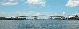
<span class="mw-page-title-main">M4 motorway</span> Major motorway in England and Wales

The M4, originally the London-South Wales Motorway, is a motorway in the United Kingdom running from west London to southwest Wales. The English section to the Severn Bridge was constructed between 1961 and 1971; the Welsh element was largely complete by 1980, though a non-motorway section around Briton Ferry bridge remained until 1993. On the opening of the Second Severn Crossing in 1996, the M4 was rerouted over it.

<span class="mw-page-title-main">Second Severn Crossing</span> M4 motorway bridge over the Severn Estuary in the United Kingdom

The Second Severn Crossing, officially named the Prince of Wales Bridge since July 2018, is the M4 motorway bridge over the River Severn between England and Wales, opened in 1996 to supplement the traffic capacity of the Severn Bridge built in 1966. The bridge is operated by England's National Highways. It has a total length of 5,128 metres (16,824 ft).

<span class="mw-page-title-main">Rest area</span> Public area, usually adjacent to limited-access highway, used for rest from travel

A rest area is a public facility located next to a large thoroughfare such as a motorway, expressway, or highway, at which drivers and passengers can rest, eat, or refuel without exiting onto secondary roads. Other names include motorway service area (UK), services (UK), travel plaza, rest stop, oasis (US), service area, rest and service area (RSA), resto, service plaza, lay-by, and service centre (Canada). Facilities may include park-like areas, fuel stations, public toilets, water fountains, restaurants, and dump and fill stations for caravans / motorhomes.

<span class="mw-page-title-main">Highways in Poland</span>

Controlled-access highways in Poland are part of the national roads network and they are divided into motorways and expressways. Both types of highways feature grade-separated interchanges with all other roads, emergency lanes, feeder lanes, wildlife crossings and dedicated roadside rest areas. Motorways differ from expressways in their technical parameters, like designated speed, permitted road curvature, lane widths or minimal distances between interchanges. Moreover, expressways might have single carriageway sections in case of low traffic densities.

<span class="mw-page-title-main">Illinois Tollway oasis</span> Rest areas on top of a highway

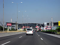
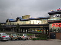
An Illinois Tollway oasis is a type of commercialized rest area sited over Interstate Highways that are part of the Illinois Tollway system in northern Illinois, United States. The four oases offer food and gasoline vendors and are found in the Chicago Metropolitan Area, DeKalb, and Belvidere. Although the oases date back to the original tollway construction in 1958, they were redeveloped in 2003–2005 by Wilton Partners, a private developer. The redevelopment of the oases has been the focal point of alleged political corruption. The four oases are administered by a court-appointed manager following default of Wilton Partners.

<span class="mw-page-title-main">Māngere Bridge (bridges)</span> Bridge in New Zealand

Māngere Bridge, officially also called the Manukau Harbour Crossing, is a dual motorway bridge over the Manukau Harbour in south-western Auckland, New Zealand, crossing between the suburb also known as Māngere Bridge and the suburb of Onehunga.

<span class="mw-page-title-main">Severn Bridge</span> Bridge over the rivers Severn and Wye in England and Wales

The Severn Bridge is a motorway suspension bridge that spans the River Severn between South Gloucestershire in England and Monmouthshire in South East Wales. It is the original Severn road crossing between England and Wales, and took three and a half years to build, at a cost of £8 million. It replaced the 137-year-old Aust Ferry.
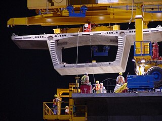
<span class="mw-page-title-main">Hampton Court Bridge</span> Bridge over the Thames linking London with Surrey, England

<span class="mw-page-title-main">M5 (Cape Town)</span> Metropolitan route in the City of Cape Town, South Africa

The M5 is an expressway in the City of Cape Town Metropolitan Municipality, South Africa. It connects Milnerton on the Western Seaboard in the north to Muizenberg in the south, and crosses both the N1 and the N2. For part of its length, from the N1 interchange to Plumstead, it is a limited-access freeway (motorway). From Mowbray to Muizenberg, it is parallel to the M4 Main Road.

<span class="mw-page-title-main">Krk Bridge</span> Bridge in Primorje-Gorski Kotar County, Croatia

Krk Bridge is a 1,430 m (4,692 ft) long reinforced concrete arch bridge connecting the Croatian island of Krk to the mainland. Carrying over a million vehicles per year, it was the last tolled bridge in Croatia that is not part of a motorway until the removal of tolls. The longer of the bridge's two arches is the third-longest concrete arch in the world and the longest outside of China, and among the longest arches of any construction. The bridge was completed and opened in July 1980 and originally named Tito's Bridge in honor of Yugoslav president Josip Broz Tito, who had died two months earlier. The bridge has since been renamed Krk Bridge or Krčki most. The bridge was tolled since its opening until the removal of tolls on 15 June 2020. However, passage was toll free for Krk residents since 1999 and vehicles owned by Krk businesses since the 2000s. When the tolls were removed, passenger cars were being charged 35 kuna, southbound only.

<span class="mw-page-title-main">Tom Uglys Bridge</span> Australian road bridge

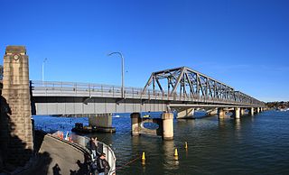
Tom Uglys Bridge are two road bridges, completed in 1929 and 1987, that carry the Princes Highway across the Georges River in southern Sydney, in the state of New South Wales, Australia. The bridges link the St George area at Blakehurst to the Sutherland Shire at Sylvania. Tom Uglys Bridge is one of six major road crossings of Georges River.

<span class="mw-page-title-main">Medway Viaducts</span> Bridge in Cuxton, England

The Medway Viaducts are three bridges or viaducts that cross the River Medway between Cuxton and Borstal in north Kent, England. The two road bridges carry the M2 motorway carriageways. The other viaduct carries the High Speed 1 railway line. All three bridges pass over the Medway Valley Line.

<span class="mw-page-title-main">A3 (Croatia)</span> Motorway in Croatia

The A3 motorway is a major motorway in Croatia spanning 306.5 kilometres (190.5 mi). The motorway connects Zagreb, the nation's capital, to the Slavonia region and a number of cities along the Sava River. It represents a major east–west transportation corridor in Croatia and a significant part of the Pan-European Corridor X, serving as a transit route between the European Union states and the Balkans. Apart from Zagreb, where the A3 motorway comprises a considerable part of the Zagreb bypass, the motorway runs near a number of significant Croatian cities.

<span class="mw-page-title-main">A7 (Croatia)</span> A 42.4-kilometre-long (26.3 mi) motorway in Croatia

The A7 motorway is a 42.4-kilometre-long (26.3 mi) motorway in Croatia. It connects the nation's largest port in Rijeka, to the Croatian motorway network, as well as to the Rupa and Pasjak border crossings to Slovenia. The motorway forms part of a longitudinal transportation corridor in Croatia, and it is a part of European route E61 Villach–Ljubljana–Trieste–Rijeka. The A7 motorway route south of Orehovica interchange, where it also intersects Pan-European corridor Vb, is a part of European route E65.

<span class="mw-page-title-main">Interstate 90 in Illinois</span> Section of Interstate Highway in Illinois, United States

Interstate 90 (I-90) in the US state of Illinois runs roughly northwest-to-southeast through the northern part of the state. From the Wisconsin state line at South Beloit, it heads south to Rockford before heading east-southeast to the Indiana state line at Chicago. I-90 traverses 124 miles (200 km) through a variety of settings, from farmland west of the Fox River Valley through the medium-density suburbs west of O'Hare International Airport, through Downtown Chicago, and through the heart of the industrial southeast side of Chicago before entering Indiana.

<span class="mw-page-title-main">Peats Ferry Bridge</span> Bridge in New South Wales, Australia

The Peats Ferry Bridge is a steel truss bridge that carries the Pacific Highway (B83) across the Hawkesbury River, between Kangaroo Point and Mooney Mooney Point, located 40 kilometres (25 mi) north of Sydney in New South Wales, Australia. The bridge carries the Hornsby to Kariong section of highway, while the adjacent Brooklyn Bridge carries the Pacific Motorway (M1).

<span class="mw-page-title-main">Maslenica Bridge (A1)</span> Bridge in Southern Croatia

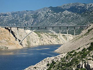
Maslenica Bridge is a 377.6 m (1,239 ft) long reinforced concrete arch bridge spanning the Novsko Ždrilo strait of the Adriatic Sea, north of Zadar, Croatia, carrying the Croatian A1 motorway. It is located between the Maslenica and Posedarje interchanges of the A1 motorway.

<span class="mw-page-title-main">Vrata Tunnel</span>

Vrata Tunnel is one of the shortest tunnels on the Croatian A6 motorway route. It is only 257 metres (843 ft) long and consists of two tunnel tubes. It is located between Oštrovica and Vrata interchanges. The tunnel is tolled within the A6 motorway closed toll collection system. There are no other toll plazas related to use of the tunnel. The tunnel was excavated by Viadukt using New Austrian Tunneling method. The tunnel was originally designed to be 325 metres (1,066 ft) long, but it was shortened due to the landslide on the western portal in the zone of contact between Paleozoic and carbonate layers. The tunnel is noteworthy since it comprises a 58-metre (190 ft) bridge spanning a cavern found during excavation.

<span class="mw-page-title-main">Autostrada A22 (Italy)</span>

The Autostrada A22 is one of the most important motorways in Italy, as it connects Pianura padana, the city of Modena and the A1 motorway to Austria through the Brenner Pass, located in the municipality of Brenner.

References

  1. Greco p. 91.
  2. Colafranceschi, p. 36.
  3. Colafranceschi, p. 37.
  4. Greco p. 115.
  5. Johannes, p. 51
  6. Greco p. 98.
  7. Greco pp. 101-109.
  8. Greco p. 110.
  9. Greco p. 208.
  10. Greco p. 118-119.
  11. Greco p. 115-117.
  12. Greco p. 133-141.
  13. Greco p. 182.
  14. Greco, p. 209.
  15. Greco, pp.  101-108
  16. Aleardi, building FI22.
  17. Greco, p.  208.
  18. Greco, p. 208.
  19. Greco, pp. 115-119.
  20. Greco, pp. 133–141.
  21. Greco, p.  110.
  22. Greco, p.  209.
  23. Aleardi, building PT10.
  24. Staff. "Belvidere Oasis". Illinois State Toll Highway Authority. Retrieved October 15, 2012.
  25. Greco, p. 91.
  26. Staff. "Des Plaines Oasis". Illinois State Toll Highway Authority. Retrieved October 15, 2012.
  27. Staff. "Hinsdale Oasis". Illinois State Toll Highway Authority. Retrieved October 15, 2012.
  28. Staff. "Lake Forest Oasis". Illinois State Toll Highway Authority. Retrieved October 15, 2012.
  29. Staff. "O'Hare Oasis". Illinois State Toll Highway Authority. Retrieved October 15, 2012.

Works cited