
Talkeetna is a census-designated place (CDP) in Matanuska-Susitna Borough, Alaska, United States. At the 2020 census the population was 1,055, up from 876 in 2010.

The Granite Mountains is a small mountain range in eastern San Bernardino County, California, USA, in the Mojave Desert. The range stretches 10.7 mi (17.2 km) from Granite Pass to Budweiser Wash. The highest peaks of this mountain range are an unnamed peak, which is 6,738 ft (2,054 m) in elevation, and Granite Peak, which is 6,766 ft (2,062 m) in elevation.

Hatcher Pass is a mountain pass through the southwest part of the Talkeetna Mountains, Alaska. It is named after Robert Hatcher, a prospector and miner. The nearest cities are Palmer and Wasilla approximately 12 miles (19 km) to the south, and Willow approximately 26 mi (42 km) to the west. The communities are at an elevation of approximately 250 ft (76 m) in the Mat-Su valley.
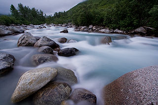
Little Susitna River (Dena'ina: Tsałtastnu) heads at Mint Glacier on Montana Peak, in Talkeetna Mountains at 61°51′30″N149°03′30″W, flows southwest to Cook Inlet, 13 miles (21 km) west of Anchorage, Alaska Cook Inlet Low.

Tukgahgo Mountain (TUG-a-ho) is a mountain in the Takshanuk Mountains in the U.S. state of Alaska with a peak elevation of 4,675 feet (1,425 m). It is located in Haines Borough, 3.5 miles (5.6 km) to the southwest of Chilkoot Lake and 16 miles (26 km) to the southwest of Skagway. Geological investigations of the veins in the mountain have revealed silver, gold, platinum, and palladium mineralization, derived from mid-Cretaceous events.
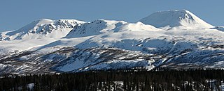
The Talkeetna Mountains are a mountain range in Alaska. The Matanuska and Susitna River valleys, with towns such as Trapper Creek, Talkeetna, Wasilla, Palmer, Sutton, and Chickaloon, roughly bound the Talkeetnas in the westerly parts of the range. Sovereign Mountain rises to 8,849 feet (2,697 m) in the remote and heavily glaciated central part of the range. The east side of the range fronts a broad, about 100 miles (160 km) wide, lake-studded lowland of forests and swamps, across which rises the gigantic Mount Wrangell volcanic edifice. Alaska Highway 4 runs northward through this lowland. Hundreds of miles to the west Alaska Highway 3 runs along the western side of the Talkeetna range, with the Alaska Range directly west. Alaska Highway 1, running along the southern front of the Talkeetna Mountains, lies mainly in a valley marking a tectonic divide between the Jurassic and Cretaceous rocks of the accretionary wedge, island-arc, and basement rocks in the Peninsular terrane, and the Chugach Mountains in the Chugach terrane to the south. The range stretches as much as a hundred miles north to south. Alaska Highway 8, seasonal and unpaved, passes over highlands rising to above 4,000 feet (1,200 m), north of the Talkeetnas.
Gold mining in Alaska, a state of the United States, has been a major industry and impetus for exploration and settlement since a few years after the United States acquired the territory in 1867 from the Russian Empire. Russian explorers discovered placer gold in the Kenai River in 1848, but no gold was produced. Gold mining started in 1870 from placers southeast of Juneau, Alaska.
Gold was discovered in the Yentna-Cache Creek Mining District in the U.S. state of Alaska of the upper Susitna River Valley in 1898, soon followed by claim staking. Placer mining was reported in the Cache Creek drainage of the Dutch Hills by 1906. Quaternary glaciofluvial deposits, alluvial deposits, and Cenozoic conglomeratic white quartz-breccia units have been mined in the Dutch Hills. About 200,000 oz of gold has been produced from these placer deposits. By 1927, a road from Talkeetna was constructed into the mining area, known today as The Petersville Road. The mining camp of Petersville, Alaska served as the area Post Office for several years in the late 1920s and early 1930s. Two areas have been set aside for recreational gold mining, the North and South units of the Petersville State Recreation Mining Areas. Many smaller one-man and family placer mining operations continue today.
The Willow Creek mining district, also known as the Independence Mine/Hatcher Pass district, is a gold-mining area in the U.S. state of Alaska. Underground hard-rock mining of gold from quartz veins accounts for most of the mineral wealth extracted from the Hatcher Pass area. The first mining efforts were placer mining of stream gravels, and placer mining in the area has continued sporadically to this day. Robert Hatcher discovered gold and staked the first claim in the Willow Creek valley in September 1906. The first lode mill in the area started operating in 1908. Underground mining continued at a variety of locations around the pass until 1951. In the 1980s one of the area's hard-rock mines was briefly re-opened. At least one mining company is actively exploring for gold in the area now. Through 2006 the district produced 667-thousand ounces of hard rock gold and 60-thousand ounces of placer gold.
The South Pass greenstone belt is located within the Wyoming Craton in the United States. The region was the site of Wyoming's initial gold discovery in 1842.

The Juneau gold belt is located in the southeastern portion of the U.S. state of Alaska. This belt is approximately 100 miles (160 km) in length, north/northwest-trending, and extends from Berners Bay southeastward to Windham Bay, 60 miles (97 km) southeast of Juneau, and includes Douglas Island. The belt contains over 200 gold-quartz-vein deposits with production nearing 7,000,000 ounces (200,000,000 g) of gold. More than three-quarters of Alaska's lode gold was mined from the Juneau gold belt.
Valdez Creek is a small headwater tributary of the Susitna River in the U.S. state of Alaska. It is also home to several gold mines, one of which was the largest placer gold mine in North America and has seen mining activity since the late 1890s.

The Independence Mines, now Independence Mine State Historic Park, is the site of a former gold mining operation in the Talkeetna Mountains, across Hatcher Pass from Palmer, Alaska. The area's mining history dates to at least 1897, when active claims were reported in the vicinity of Fishook Creek. These early mining efforts were eventually joined to form the Wasilla Mining Company, which worked the mines from 1934 to 1943, and again from 1948 to 1950. The mining operation at Independence was the second-largest hard-rock gold mining operation in the state, after a larger site near Juneau. The company and the miners that preceded it built a substantial mining camp, with as many as sixteen wood-frame buildings, which were originally connected to each other by sheltered wooden "tunnels". When the company ended operations in 1950, it had expected to eventually resume operations, but never did; this resulted in a particularly well-preserved collection of mining equipment and buildings, although the weather has since taken a significant toll on the latter.
Quartzburg is an unincorporated town in Boise County, in the U.S. state of Idaho.
Government Peak is a 4,781-foot-elevation (1,457-meter) summit in Alaska, United States.

Skyscraper Mountain is a 4,784-foot-elevation (1,458-meter) summit in Alaska, United States.

Troublemint Peak is a 6,801-foot-elevation (2,073-meter) summit in Alaska, United States.

Triplemint Peak is a 6,332-foot-elevation (1,930-meter) summit in Alaska, United States.

Lynx Peak is a 6,536-foot-elevation (1,992-meter) summit in Alaska, United States.

Doublemint Peak is a 6,372-foot-elevation (1,942-meter) summit in Alaska, United States.


