Buruanga, Aklan

Last updated
Buruanga
Municipality of Buruanga
Seal of Buruanga.png
Seal
Ph locator aklan buruanga.png
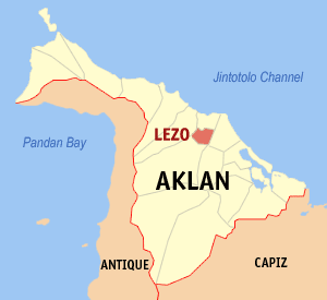
Map of Aklan with Buruanga highlighted
Philippines location map (square).svg
Red pog.svg
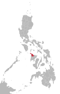
Buruanga
Location within the Philippines
Coordinates: 11°51′N121°54′E / 11.85°N 121.9°E / 11.85; 121.9 Coordinates: 11°51′N121°54′E / 11.85°N 121.9°E / 11.85; 121.9
Country Flag of the Philippines.svg  Philippines
Region Western Visayas (Region VI)
Province Aklan
District Lone district
Barangays 15 (see Barangays)
Government
[1]
  Type Sangguniang Bayan
   Mayor Quezon F. Labindao
  Electorate11,286 voters (2016)
Area
[2]
  Total88.50 km2 (34.17 sq mi)
Population
(2015 census) [3]
  Total19,003
  Density210/km2 (560/sq mi)
Time zone UTC+8 (PST)
ZIP code
5609
PSGC
IDD : area code +63(0)36
Climate type Tropical climate
Income class 5th municipal income class
Revenue (₱)66.6 million (2016)
Native languagesAklan language
Ati
Tagalog

Buruanga, officially the Municipality of Buruanga, (Aklanon: Banwa it Buruanga; Hiligaynon: Banwa sang Buruanga; Tagalog : Bayan ng Buruanga), is a 5th class municipality in the province of Aklan, Philippines. According to the 2015 census, it has a population of 19,003 people. [3]

Aklanon language language spoken in the province of Aklan on the island of Panay in the Philippines

Aklanon (Akeanon), also known as Aklan, is a regional Visayan language spoken in the province of Aklan on the island of Panay in the Philippines. Its unique feature among other Visayan languages is the close-mid back unrounded vowel [ɤ] occurring as part of diphthongs and traditionally written with the letter E such as in the name Akeanon (Aklanon). However, this phoneme is also present in sister Philippine languages, namely Itbayat, Isneg, Manobo, Samal and Sagada.

Hiligaynon language Austronesian language spoken in the Western Visayas region of the Philippines

The Hiligaynon language, also often referred to by most of its speakers simply as Ilonggo, is an Austronesian regional language spoken in the Philippines by about 9.1 million people, mainly in Western Visayas and Soccsksargen, most of whom belong to the Visayan ethnic group, mainly the Hiligaynons. It is the second-most widely spoken language and a member of the so-named Visayan language family and is more distantly related to other Philippine languages.

Tagalog language Austronesian language

Tagalog is an Austronesian language spoken as a first language by a quarter of the population of the Philippines and as a second language by the majority. Its standardized form, officially named Filipino, is the national language of the Philippines, and is one of two official languages alongside English.

Contents

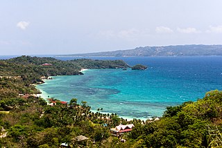
Buruanga is located at the western tip of Panay Island. It is a coastal town bounded on the north by Malay; south by Libertad, Antique; and west by the Cuyo East Pass of the Sulu Sea.

Malay, Aklan Municipality of the Philippines in the province of Aklan

Malay, officially the Municipality of Malay,, is a 1st class municipality in the province of Aklan, Philippines. According to the 2015 census, it has a population of 52,973 people.

Libertad, Antique Municipality of the Philippines in the province of Antique

Libertad, officially the Municipality of Libertad,, is a 5th class municipality in the province of Antique, Philippines. According to the 2015 census, it has a population of 16,429 people.

Sulu Sea A sea in the Philippines between Palawan, the Sulu Archipelago, Borneo and Visayas

The Sulu Sea is a body of water in the southwestern area of the Philippines, separated from the South China Sea in the northwest by Palawan and from the Celebes Sea in the southeast by the Sulu Archipelago. Borneo is found to the southwest and Visayas to the northeast.

History

The name Buruanga came from the word Busuanga meaning "eruption" or "swell". Frequently harassed by inundations from the river, the early residents constructed earthen dams which were subsequently washed away. The people named the river "Busuanga," which later became the name of the Municipality. When the Spaniards arrived, they renamed Busuanga to Buruanga, or perhaps the change was purely a clerical error. The present municipality of Malay, including Boracay, was once a part of Buruanga. On June 15, 1949, the enactment of Republic Act 391 separated Malay from Buruanga to become an independent municipality. [4]

Boracay Island

Boracay is a small island in the Philippines located approximately 315 kilometres (196 mi) south of Manila and 2 kilometres (1.2 mi) off the northwest tip of Panay Island in Western Visayas region of the Philippines. Boracay Island and its beaches have received awards from numerous travel publications and agencies. The island comprises the barangays of Manoc-Manoc, Balabag, and Yapak in the municipality of Malay, in Aklan Province. The island is administered by the Tourism Infrastructure and Enterprise Zone Authority and the provincial government of Aklan. Apart from its white sand beaches, Boracay is also famous for being one of the world's top destinations for relaxation. As of 2013 it was emerging among the top destinations for tranquility and nightlife.

It was hit severely by typhoon Seniang on 9–10 December 2006, with much destruction and damage of homes and infrastructure. [5]

Geography

Buruanga is located at 11°51′N121°54′E / 11.85°N 121.9°E / 11.85; 121.9 . It is 81 kilometres (50 mi) from the provincial capital Kalibo.

Kalibo Municipality of the Philippines and capital of the province of Aklan

Kalibo, officially the Municipality of Kalibo,, is a 1st class municipality and capital of the province of Aklan, Philippines. According to the 2015 census, it has a population of 80,605 people.

According to the Philippine Statistics Authority, the municipality has a land area of 88.50 square kilometres (34.17 sq mi) [2] constituting 4.86% of the 1,821.42-square-kilometre- (703.25 sq mi) total area of Aklan.

Philippine Statistics Authority Philippines principal government institution in charge of statistics and census data

The Philippine Statistics Authority (PSA) was created on September 12, 2013 when the Philippine Statistical Act of 2013 was signed by President Benigno S. Aquino III. The new government authority was created by merging the National Statistics Office, the National Statistical Coordination Board, the Bureau of Agricultural Statistics, and the Bureau of Labor and Employment Statistics.

Climate

There is one prevailing type of climate identified as Type I, two pronounced seasons which are dry from November to April and wet for the rest of the year. This is also true in all municipalities of Western Aklan such as Malay (excluding Boracay Island) and Nabas, as well as the Western portion of the municipalities bounding Antique.

In these areas, including Buruanga, the wettest month is August with rainfall averaging 625 millimetres (24.6 in) and the driest is March with rainfall of only about 150 millimetres (5.9 in). The average temperature if the area is 27.9 °C (82.2 °F) with an average humidity of 77.8%. The wet season coincides with the planting of rice while offshore fishing is in full gear during the dry season. Typhoons and strong winds rarely occur, and if it ever occurs, it coincides with the wet season. The humid north-western monsoon arrives in the area by June causing an increase in rainfall which reaches its peak in the month of August.

Barangays

Buruanga is politically subdivided into 15 barangays. [6]

PSGC Barangay Population ±% p.a.
2015 [3] 2010 [7]
060405001 Alegria 9.0% 1,709 1,695 0.16%
060405002 Bagongbayan 5.5% 1,050 951 1.90%
060405003 Balusbos 5.7% 1,085 930 2.98%
060405004 Bel-is 3.8% 722 695 0.73%
060405005 Cabugan 4.6% 882 696 4.61%
060405006 El Progreso 6.0% 1,147 946 3.74%
060405007 Habana 9.7% 1,850 1,605 2.74%
060405008 Katipunan 10.6% 2,006 1,708 3.11%
060405009 Mayapay 5.8% 1,106 1,033 1.31%
060405010 Nazareth 10.1% 1,923 1,696 2.42%
060405011 Panilongan 6.2% 1,186 1,062 2.12%
060405012 Poblacion 5.6% 1,062 1,116 −0.94%
060405013 Santander 7.0% 1,330 1,210 1.82%
060405014 Tag-osip 1.6% 299 255 3.08%
060405015 Tigum 8.7% 1,646 1,364 3.64%
Total19,00316,9622.19%

Demographics

Population census of Buruanga
YearPop.±% p.a.
1903 6,120    
1918 8,050+1.84%
1939 11,351+1.65%
1948 12,514+1.09%
1960 8,393−3.27%
1970 9,291+1.02%
1975 10,311+2.11%
1980 10,764+0.86%
1990 12,653+1.63%
1995 12,665+0.02%
2000 15,077+3.81%
2007 15,767+0.62%
2010 16,962+2.69%
2015 19,003+2.19%
Source: Philippine Statistics Authority [3] [7] [8] [9]

In the 2015 census, Buruanga had a population of 19,003. [3] The population density was 210 inhabitants per square kilometre (540/sq mi).


Tourism

Despite its proximity to Boracay, one of the most popular tourist destinations in the Philippines, Buruanga sees very few tourists. This has left the area as a secret hideaway. Various scenic spots such as caves, waterfalls, beaches, hills, and mountain parks are found throughout the area such as the Hinugtan White Beach, Batason (Ariel’s) Point, Langka Beach, Nasog Beach, Tuburan Baybay Beach, Tigis Beach/Falls, and Pagatpat Mangrove Park.

Flora and fauna

The upland barangay of Tag-Osip contains a portion of the Northwest Panay Peninsula Natural Park which is contained within the municipalities of Buruanga, Malay, and Nabas in Aklan Province and Libertad and Pandan in Antique. The park is home to many important plant and animal species such as the Visayan leopard cat, the blue-necked parrot, the Visayan hornbill, and the roughneck monitor lizard. [10]

In 2011, several researchers from the United States Peace Corps conducted various biological assessments along the Buruanga coastline. It was found that Buruanga hosts 4 different species of mangroves including large tracts of nypa found in the barangays of Alegria, Balusbos, Poblacion, and Santander. Other species including pagatpat, bakawan, and piyapi are concentrated in Pagatpat Mangrove Park in barangay Panilongan with a few trees in spotted areas in barangay Santander. Buruanga also is home to 5 different species of seagrass identified including Cymodocea rotundata , Cymodocea serrulata , Halodule pinifolia , Halophila ovalis and Thalassia hemprichii .[ citation needed ]

Related Research Articles

Western Visayas Region in Visayas, Philippines

Western Visayas is an administrative region in the Philippines, numerically designated as Region VI. It consists of six provinces and two highly urbanized cities. The regional center is Iloilo City. The region is dominated by the native speakers of four Visayan languages: Kinaray-a, Hiligaynon, Aklanon and Capiznon. The land area of the region is 20,794.18 km2 (8,028.68 sq mi), and with a population of 7,536,383 inhabitants, it is the most populous region in the Visayas.

Malinao, Aklan Municipality of the Philippines in the province of Aklan

Malinao, officially the Municipality of Malinao,, is a 4th class municipality in the province of Aklan, Philippines. According to the 2015 census, it has a population of 23,194 people.

Altavas Municipality of the Philippines in the province of Aklan

Altavas, officially the Municipality of Altavas,, is a 4th class municipality in the province of Aklan, Philippines. According to the 2015 census, it has a population of 24,619 people.

Balete, Aklan Municipality of the Philippines in the province of Aklan

Balete, officially the Municipality of Balete,, is a 4th class municipality in the province of Aklan, Philippines. According to the 2015 census, it has a population of 28,920 people.

Banga, Aklan Municipality of the Philippines in the province of Aklan

Banga, officially the Municipality of Banga,, is a 3rd class municipality in the province of Aklan, Philippines. According to the 2015 census, it has a population of 39,505 people.

Batan, Aklan Municipality of the Philippines in the province of Aklan

Batan, officially the Municipality of Batan,, is a 4th class municipality in the province of Aklan, Philippines. According to the 2015 census, it has a population of 32,032 people.

Lezo, Aklan Municipality of the Philippines in the province of Aklan

Lezo, officially the Municipality of Lezo,, is a 5th class municipality in the province of Aklan, Philippines. According to the 2015 census, it has a population of 15,224 people.

Libacao Municipality of the Philippines in the province of Aklan

Libacao, officially the Municipality of Libacao,, is a 3rd class municipality in the province of Aklan, Philippines. According to the 2015 census, it has a population of 28,241 people.

Makato Municipality of the Philippines in the province of Aklan

Makato, officially the Municipality of Makato,, is a 4th class municipality in the province of Aklan, Philippines. According to the 2015 census, it has a population of 27,262 people.

Nabas, Aklan Municipality of the Philippines in the province of Aklan

Nabas, officially the Municipality of Nabas,, is a 4th class municipality in the province of Aklan, Philippines. According to the 2015 census, it has a population of 36,435 people.

New Washington, Aklan Municipality of the Philippines in the province of Aklan

New Washington, officially the Municipality of New Washington,, is a 3rd class municipality in the province of Aklan, Philippines. According to the 2015 census, it has a population of 45,007 people.

Numancia, Aklan Municipality of the Philippines in the province of Aklan

Numancia, officially the Municipality of Numancia,, is a 4th class municipality in the province of Aklan, Philippines. According to the 2015 census, it has a population of 31,934 people.

Tangalan Municipality of the Philippines in the province of Aklan

Tangalan, officially the Municipality of Tangalan,, is a 5th class municipality in the province of Aklan, Philippines. According to the 2015 census, it has a population of 21,916 people.

Culasi Municipality of the Philippines in the province of Antique

Culasi, officially the Municipality of Culasi,, is a 3rd class municipality in the province of Antique, Philippines. According to the 2015 census, it has a population of 41,228 people. The municipality is known as the home of Mount Madia-as, an enchanted mountain sacred to ancient Visayans as it is home to the god of death, Sidapa, boy-god of the moon, Bulan, and god of meteors, Bulalakaw.

Sapian Municipality of the Philippines in the province of Capiz

Sapian, officially the Municipality of Sapian,, and sometimes spelled Sapi-an, is a 4th class municipality in the province of Capiz, Philippines. According to the 2015 census, it has a population of 25,821 people. It is 27 kilometres (17 mi) from Roxas City, the provincial capital.

Ati (Inati) is an Austronesian language of the island of Panay in the Philippines. The variety spoken in northern Panay is also called Sogodnin. The Ati people also speak Kinaray-a and Hiligaynon.

References

  1. "Municipality". Quezon City, Philippines: Department of the Interior and Local Government. Retrieved 31 May 2013.
  2. 1 2 "Province: Aklan". PSGC Interactive. Quezon City, Philippines: Philippine Statistics Authority . Retrieved 12 November 2016.
  3. 1 2 3 4 5 Census of Population (2015). "Region VI (Western Visayas)". Total Population by Province, City, Municipality and Barangay. PSA . Retrieved 20 June 2016.
  4. "Republic Act No. 381; an Act Creating the Municipality of Malay in the Province of Capiz". PhilippineLaw.info. 15 June 1949. Archived from the original on 22 October 2014. Retrieved 20 October 2016.
  5. Villanueva, VG (20 December 2006). "Aklan final tally from typhoon Seniang: P479-M in damages". Philippine Information Agency. Archived from the original on 20 October 2016. Retrieved 20 October 2016.
  6. "Municipal: Buruanga, Aklan". PSGC Interactive. Quezon City, Philippines: Philippine Statistics Authority . Retrieved 8 January 2016.
  7. 1 2 Census of Population and Housing (2010). "Region VI (Western Visayas)". Total Population by Province, City, Municipality and Barangay. NSO . Retrieved 29 June 2016.
  8. Censuses of Population (1903–2007). "Region VI (Western Visayas)". Table 1. Population Enumerated in Various Censuses by Province/Highly Urbanized City: 1903 to 2007. NSO.
  9. "Province of Aklan". Municipality Population Data. Local Water Utilities Administration Research Division. Retrieved 17 December 2016.
  10. "Panay Eco-Social Conservation Project". Panay Eco-Social Conservation Project. Conservation Biology Unit, Ruhr-University Bochum. 30 August 2013. Archived from the original on 4 March 2016. Retrieved 20 October 2016.