
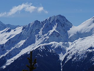
Silver Star Mountain is an 8,876-foot (2,705-metre) mountain located in Okanogan County, Washington. The mountain is part of the Methow Mountains, a subset of the Cascade Range. Silver Star is the dominant feature in the Washington Pass area and visible from the North Cascades Highway. It was first climbed by Lage Wernstedt in 1926.

Mount Blum, or Mount Bald, is a 7,685-foot (2,342 m) summit of the North Cascades range in Washington state, on the western edge of North Cascades National Park. It is the highest summit of a string of mountain peaks located east of Mount Shuksan and west of the Picket Range. Two small active glaciers rest on its northern flank. Mount Blum was named after John Blum, a United States Forest Service fire patrol pilot who perished in a plane crash near Snoqualmie Pass in 1931.
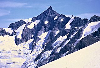
Forbidden Peak is an 8,815 feet (2,687 m) glacial horn located in North Cascades National Park, in Skagit County of Washington state. It is part of the North Cascades and is located near Cascade Pass. Forbidden Peak features a rock climbing route named West Ridge route which is featured in Fifty Classic Climbs of North America. The peak was first climbed by a party consisting of Fred Beckey, his brother Helmy Beckey, Jim Crooks, Lloyd Anderson and Dave Lind in 1940.

Icy Peak is a 7,073-foot (2,156-metre) Skagit Range mountain summit located in the North Cascades of Washington state. It is situated in North Cascades National Park at the head of Nooksack Cirque. High ridges connect it to Seahpo Peak and Mount Shuksan. An icefall occupies the northeast cirque, and small glaciers clad all sides of the peak. Precipitation runoff drains into the Nooksack and Baker Rivers.

Magic Mountain is a 7,610-foot (2,320-metre) mountain summit located on the shared boundary of Skagit County and Chelan County in Washington state. It is part of the North Cascades, a subset of the Cascade Range. Magic Mountain is situated southeast of Cascade Pass on the shared border of North Cascades National Park and Glacier Peak Wilderness. The nearest peak is Pelton Peak 0.4 miles (0.64 km) to the northeast, and the nearest higher peak is Hurry-up Peak 0.83 miles (1.34 km) to the south. The Yawning Glacier and Cache Col Glacier rest on its northern flank. Magic Mountain is at the northern end of the Ptarmigan Traverse. Surface runoff on the north side the mountain drains into the Stehekin River, while precipitation drains into the Cascade River from the southwest side.

Mix-up Peak, also known as Mixup Peak, is a 7,440-foot (2,270-metre) mountain summit located on the shared boundary of Skagit County and Chelan County in Washington state. It is part of the North Cascades Range and is situated one mile south of Cascade Pass on the shared border of North Cascades National Park and Glacier Peak Wilderness. The nearest higher peak is Magic Mountain, 1.02 miles (1.64 km) to the east-southeast. Mix-up Peak is at the northern end of the Ptarmigan Traverse which is an alpine route to remote mountains such as Mount Formidable and Dome Peak. The Cache Glacier occupies a cirque below its eastern flank. Surface runoff on the east side the mountain drains into the Stehekin River, whereas precipitation runoff drains into the Cascade River from the west side.

Mount Misch is a remote 7,435 ft mountain summit in the North Cascades, in Skagit County of Washington state. It is the highest point of the Buckindy Range, or Buckindy Ridge. It is located 19 miles east-northeast of Darrington, Washington, and 15 miles north-northwest of Glacier Peak which is one of the Cascade stratovolcanoes. It is situated in the Glacier Peak Wilderness on land administered by the Mount Baker-Snoqualmie National Forest. Mount Misch was named by mountaineer and author Fred Beckey for his friend Peter Misch (1909-1987), University of Washington geology professor and mountaineer, who was renowned for his study of the North Cascades. Precipitation runoff from Mount Misch and the unnamed Goat Creek glacier on its east slope drains into tributaries of the Suiattle River and ultimately the Skagit River.

Hurry-up Peak is a 7,821-foot-elevation summit located on the shared boundary of Skagit County and Chelan County in Washington state. It is positioned on the crest of the North Cascades Range, and is set at the northern end of the Ptarmigan Traverse. Hurry-up Peak is situated southeast of Cascade Pass on the shared border of North Cascades National Park and Glacier Peak Wilderness. The nearest higher peak is Spider Mountain, 1.49 miles (2.40 km) to the south, with Magic Mountain 0.83 miles (1.34 km) to the north, and Trapper Mountain 0.7 miles (1.1 km) to the east. The S Glacier rests on the eastern flank of the peak and meltwater from it drains into Trapper Lake. Precipitation runoff on the east side the mountain drains into tributaries of the Stehekin River, while precipitation drains into the Cascade River from the west side. Ess Mountain and S Mountain are variant names for Hurry-up Peak. This geographical feature's toponym was officially adopted in 1969 by the U.S. Board on Geographic Names.

Mount Chaval is a craggy 7,127-foot (2,172-metre) mountain summit located in Skagit County of Washington state. Situated within the Glacier Peak Wilderness, Mount Chaval is positioned west of the crest of the North Cascades Range, approximately 15 miles northeast of the town of Darrington. It has two subsidiary peaks, East Peak and Middle Peak, each 7040 ft. The nearest higher neighbor is Snowking Mountain, 2.51 miles (4.04 km) to the northeast. Precipitation runoff from Mount Chaval drains into tributaries of the Skagit River.

Snowking Mountain is a 7,433-foot (2,266-metre) summit located in Skagit County of Washington state. Situated within the Glacier Peak Wilderness, Snowking Mountain is positioned west of the crest of the North Cascades, approximately 18 miles northeast of the town of Darrington. It is set within the Glacier Peak Wilderness, on land managed by Mount Baker–Snoqualmie National Forest. Snowking has two subsidiary peaks, West Peak (7,425 ft), and Middle Peak (7,400 ft). A broad unnamed glacier known colloquially as Snowking Glacier rests on the north face. Downslope of that glacier are Snowking Lake, Found Lake, and Cyclone Lake. Mount Tommy Thompson is three miles to the northwest, and the nearest higher neighbor is Mount Misch, 5.75 miles (9.25 km) to the southeast. Precipitation runoff from Snowking Mountain drains into tributaries of the Skagit River.

Cascade Peak is a 7,428-foot (2,264-metre) mountain summit located in Skagit County of Washington state. It is in the North Cascades, which is a subrange of the Cascade Range. The peak is situated above Cascade Pass, on the shared border of North Cascades National Park and Glacier Peak Wilderness. The nearest higher peak is Johannesburg Mountain, 0.53 miles (0.85 km) to the west-southwest, and The Triplets stand guard 0.35 miles (0.56 km) to the east-southeast. Surface runoff from the mountain drains into the Cascade River.
Tricouni Peak is an 8,102-foot (2,469-metre) mountain summit located in Skagit County of Washington state. It is situated in North Cascades National Park, north of the North Klawatti Glacier and southeast of the Borealis Glacier. The nearest higher peak is Primus Peak, 0.54 mi (0.87 km) to the west. Precipitation runoff from Tricouni drains into Thunder Creek. The peak is named for the tricouni which was used for traction on ice, and the approach to the peak involves traversing a glacier.
Kololo Peaks is an 8,200+ ft mountain located in the Glacier Peak Wilderness of the North Cascades in Washington state. The mountain is situated on the crest of the Cascade Range, on the shared border of Snohomish County and Chelan County, and also straddling the boundary between Mount Baker-Snoqualmie National Forest and Wenatchee National Forest. The nearest higher peak is Glacier Peak, 3.29 mi (5.29 km) to the north. Precipitation runoff and meltwater from the White River Glacier on the southeast slope drains into White River. On the west slope, the White Chuck Glacier drains into the White Chuck River, and the Suiattle Glacier and Honeycomb Glacier on the north and east sides drain into the Suiattle River. Surrounded by these glaciers, Fred Beckey in his Cascade Alpine Guide describes the mountain as being almost a nunatak.

Tupshin Peak is an 8,347-foot (2,544-metre) mountain summit located in the Glacier Peak Wilderness of the North Cascades in Washington state. The mountain is situated in Chelan County, on land managed by Wenatchee National Forest. The nearest higher neighbor is Devore Peak, 1.55 mi (2.49 km) to the south-southwest, and Bonanza Peak lies 6.71 mi (10.80 km) to the southwest. Precipitation runoff from the peak drains to nearby Lake Chelan via tributaries of the Stehekin River. The mountain's name comes from Chinook jargon and means "needle".

Pinnacle Peak is a 7,386 ft (2,251 m) mountain summit in the North Cascades Range of Washington, United States. It is located within North Cascades National Park, between Pyramid Peak and Paul Bunyans Stump, which is the nearest higher peak. It rises steeply from Diablo Lake, one of the reservoirs on the Skagit River. It is part of a group of peaks that form the northern end of a chain running south through climbing destinations such as Colonial Peak and Snowfield Peak. Like many North Cascade peaks, Pinnacle Peak is more notable for its large, steep rise above local terrain than for its absolute elevation. Precipitation runoff from the mountain drains into Diablo Lake and Skagit River. The approach is via the Pyramid Lake Trail, starting near Diablo Dam on the North Cascades Highway. From the lake, there is route-finding up Pyramid Arm to Colonial Glacier.

Brahma Peak is a remote 8,079-foot (2,462-metre) mountain summit located on Chiwawa Ridge in the North Cascades, in Chelan County of Washington state. The mountain is situated in the Glacier Peak Wilderness, on land managed by the Wenatchee National Forest. The nearest higher neighbor is Buck Mountain, 1.8 mi (2.9 km) to the north. Brahma and Buck are set on Chiwawa Ridge, and other notable peaks on this ridge include Fortress Mountain, Cirque Mountain, Napeequa Peak, Mount Berge, Bandit Peak, and Chiwawa Mountain. Precipitation runoff from Brahma and meltwater from its glacier remnants drains into Chiwawa River and Napeequa River, both tributaries of the Wenatchee River. Topographic relief is significant since the southwest lavender-colored schist cliffs of this peak rise nearly 4,000 feet above the Napeequa River Valley in approximately one mile.

Bearcat Ridge is an 8,033-foot (2,448-metre) mountain ridge located in the Chelan Mountains, in Chelan County of Washington state. It is situated on the boundary of Glacier Peak Wilderness, on land managed by Wenatchee National Forest. Its nearest higher neighbor is Emerald Peak, 1.1 mi (1.8 km) to the south-southwest, and Cardinal Peak is positioned 1.76 mi (2.83 km) to the south. Precipitation runoff from the ridge drains into nearby Lake Chelan via Emerald Creek and Bearcat Creek. Bearcat Ridge forms the high divide between these two creek valleys.

Mount Berge is a 7,951-foot (2,423-metre) double-summit granitic mountain located in the Glacier Peak Wilderness of the North Cascades, in Chelan County of Washington state. The mountain is situated along the crest of the Cascade Range, on land managed by the Okanogan–Wenatchee National Forest. Its nearest higher neighbor is Napeequa Peak, 1.2 mi (1.9 km) to the west, and Buck Mountain is 1.7 mi (2.7 km) to the east-southeast. Berge is positioned on Chiwawa Ridge with Buck and Napeequa, and other notable peaks on this ridge include Fortress Mountain, Brahma Peak, Cirque Mountain, Helmet Butte, and Chiwawa Mountain. Precipitation runoff from Berge drains to the headwaters of Napeequa River; or east into tributaries of the Chiwawa River.

Bandit Peak is a 7,625-foot (2,324-metre) double-summit granitic mountain located in the Glacier Peak Wilderness of the North Cascades, in Chelan County of Washington state. The mountain is situated east of the crest of the Cascade Range, on land managed by the Okanogan–Wenatchee National Forest. Its nearest higher neighbor is Brahma Peak, 5.9 mi (9.5 km) to the north. Bandit Peak is the ninth-highest peak on Chiwawa Ridge, and other notable peaks on this ridge include Mount Berge, Buck Mountain, Cirque Mountain, Napeequa Peak, Helmet Butte, and Chiwawa Mountain. Precipitation runoff from Bandit Peak drains west into Napeequa River; or east into the Chiwawa River.
Mount Buckindy is a remote 7,320-foot-elevation (2,230-meter) mountain summit located in the North Cascades, in Skagit County of Washington state. It is the second-highest point of the Buckindy Range, or Buckindy Ridge. It is set in the Glacier Peak Wilderness on land managed by the Mount Baker-Snoqualmie National Forest. It is situated 20 miles east-northeast of Darrington, Washington, and 17 miles north-northwest of Glacier Peak which is one of the Cascade stratovolcanoes. Precipitation runoff from Mount Buckindy drains south to the Suiattle River via Buck Creek and Downey Creek, and north to the Cascade River via Kindy Creek. Topographic relief is significant as the summit rises 4,700 feet above Kindy Creek in less than two miles. The mountain's toponym is a portmanteau of Buck and Kindy Creeks, and has been officially adopted by the United States Board on Geographic Names.


