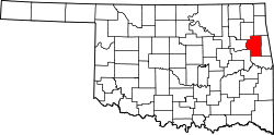
Caney Ridge, Oklahoma

Last updated

Caney Ridge, Oklahoma
USA Oklahoma location map.svg
Red pog.svg
Caney Ridge
Usa edcp location map.svg
Red pog.svg
Caney Ridge
Coordinates: 35°45′52″N94°52′51″W / 35.76444°N 94.88083°W / 35.76444; -94.88083
CountryUnited States
State Oklahoma
County Cherokee
Area
[1]
  Total0.44 sq mi (1.14 km2)
  Land0.28 sq mi (0.73 km2)
  Water0.16 sq mi (0.41 km2)
Elevation
[2]
712 ft (217 m)
Population
 (2020)
  Total120
  Density425.53/sq mi (164.40/km2)
Time zone UTC-6 (Central (CST))
  Summer (DST) UTC-5 (CDT)
ZIP Code
74471 (Welling)
Area code(s) 918/539
FIPS code 40-11575
GNIS feature ID2812846 [2]

Caney Ridge is an unincorporated community and census-designated place (CDP) in Cherokee County, Oklahoma, United States, within the Cherokee Nation. It was first listed as a CDP prior to the 2020 census. [2]

The CDP is in southeastern Cherokee County, on a ridge between two arms of Tenkiller Ferry Lake: Caney Creek to the north and Dry Creek to the south. The CDP is bordered to the north by Tenkiller, to the east by Barber, and to the south by Dry Creek. The western tip of the CDP touches the Illinois River in Tenkiller Ferry Lake.

Oklahoma State Highway 100 passes through Caney Ridge, leading east 17 miles (27 km) to Stilwell and southwest 1 mile (1.6 km) to its end at State Highway 82, which leads northwest 13 miles (21 km) to Tahlequah, the Cherokee county seat.

Demographics

Historical population
CensusPop.Note
2020 120
U.S. Decennial Census [3]

Related Research Articles

<span class="mw-page-title-main">Montgomery County, Kansas</span> County in Kansas, United States

Montgomery County is a county located in Southeast Kansas. Its county seat is Independence, and its most populous city is Coffeyville. As of the 2020 census, the county population was 31,486. The county was named after Richard Montgomery, a major general during the American Revolutionary War.

<span class="mw-page-title-main">Cherokee County, Oklahoma</span> County in Oklahoma, United States

Cherokee County is a county located in the U.S. state of Oklahoma. As of the 2020 census, the population was 47,078. Its county seat is Tahlequah, which is also the capital of the Cherokee Nation.

<span class="mw-page-title-main">Jackson County, North Carolina</span> County in North Carolina, United States

Jackson County is a county located in the western part of the U.S. state of North Carolina. As of the 2020 census, the population was 43,109. Since 1913, its county seat has been Sylva, which replaced Webster.

<span class="mw-page-title-main">Dry Creek, Oklahoma</span> Census-designated place in Oklahoma, United States

Dry Creek is an unincorporated community and census-designated place (CDP) in Cherokee County, Oklahoma, United States. The population was 227 at the 2010 census.

<span class="mw-page-title-main">Keys, Oklahoma</span> Census-designated place in Oklahoma, United States

Keys is an unincorporated community and census-designated place (CDP) in Cherokee County, Oklahoma, United States. The population was 565 at the 2010 census.

<span class="mw-page-title-main">Park Hill, Oklahoma</span> Census-designated place in Oklahoma, United States

Park Hill is an unincorporated community and census-designated place (CDP) in southwestern Cherokee County, Oklahoma, United States. The population was 3,909 at the 2010 census. It lies near Tahlequah, east of the junction of U.S. Route 62 and State Highway 82.

<span class="mw-page-title-main">Tenkiller, Oklahoma</span> Census-designated place in Oklahoma, United States

Tenkiller is an unincorporated community and census-designated place (CDP) in Cherokee County, Oklahoma, United States. The population was 633 at the 2010 census.

<span class="mw-page-title-main">Welling, Oklahoma</span> Census-designated place in Oklahoma, United States

Welling is an unincorporated community and census-designated place (CDP) in Cherokee County, Oklahoma, United States. The population was 771 at the 2010 census, an increase of 15.25 percent over the figure of 669 recorded in 2000. It is home to The Salvation Army's Heart o' Hills camp and conference center.

<span class="mw-page-title-main">Copan, Oklahoma</span> Town in Oklahoma, United States

Copan is a town in Washington County, Oklahoma, United States. The population was 733 at the 2010 census, a decline of 7.9 percent from the figure of 796 recorded in 2000.

<span class="mw-page-title-main">Illinois River (Oklahoma)</span> Scenic Ozark river in Arkansas and Oklahoma

The Illinois River is a 145-mile-long (233 km) tributary of the Arkansas River in the U.S. states of Arkansas and Oklahoma. The Osage Indians named it Ne-eng-wah-kon-dah, which translates as "Medicine Stone River." The state of Oklahoma has designated its portion as a Scenic River. The Illinois River is a significant location in the 1961 Wilson Rawls novel, Where the Red Fern Grows.

<span class="mw-page-title-main">Tenkiller Ferry Lake</span> Oklahoma reservoir on the Illinois River

Tenkiller Ferry Lake, or more simply, Lake Tenkiller, is a reservoir in eastern Oklahoma formed by the damming of the Illinois River. The earth-fill dam was constructed between 1947 and 1952 by the United States Army Corps of Engineers for purposes of flood control, hydroelectric power generation, water supply and recreation. It went into full operation in 1953. The lake and dam were named for the Tenkiller family, prominent Cherokees who owned the land and ferry that were bought for the project. This is 6th largest lake in Oklahoma, based on water capacity.

Bowring is an unincorporated community and Census designated place in Osage County, Oklahoma, United States. The post office was established November 12, 1923. It is said to have been named from the combination of the names of two local ranchers, Mart Bowhan and Richard Woodring.

<span class="mw-page-title-main">Titanic, Oklahoma</span> Census-designated place in Oklahoma, United States

Titanic is a census-designated place (CDP) in Adair County, Oklahoma, United States. The population was 356 at the 2010 census. It was presumably named after the famous ocean liner RMS Titanic.

Butler is an unincorporated community and census-designated place (CDP) in Delaware County, Oklahoma, United States. The population was 117 at the 2010 census.

Twin Lakes is a census-designated place in Ferry County, Washington, United States.

Caney Creek is a watercourse in Adair County and Cherokee County in Oklahoma. It forms just southeast of Stilwell and travels on an arc generally northwest, west, and then southwest before emptying into Tenkiller Ferry Lake on the Illinois River east of Pettit.

Barber is an unincorporated community and census-designated place (CDP) in Cherokee County, Oklahoma, United States, in the Cherokee Nation. It was first listed as a CDP prior to the 2020 census.

Caney is a census-designated place (CDP) in Cherokee County, Oklahoma, United States, within the Cherokee Nation. It was first listed as a CDP prior to the 2020 census. It includes the unincorporated community of Tailholt.

Etta is a census-designated place (CDP) in Cherokee County, Oklahoma, United States, within the Cherokee Nation. It was first listed as a CDP prior to the 2020 census.

Capitol View is an unincorporated part of Richland County, South Carolina, United States, consisting of several neighborhoods that are next to the city of Columbia, the state capital. The area was first listed as a census-designated place (CDP) prior to the 2020 census. In 2020 its population was 4,653.

References

  1. "ArcGIS REST Services Directory". United States Census Bureau. Retrieved September 20, 2022.
  2. 1 2 3 U.S. Geological Survey Geographic Names Information System: Caney Ridge, Oklahoma
  3. "Census of Population and Housing". Census.gov. Retrieved June 4, 2016.