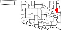
Steely Hollow, Oklahoma | |
---|---|
Coordinates: 35°59′16″N94°56′44″W / 35.98778°N 94.94556°W | |
Country | United States |
State | Oklahoma |
County | Cherokee |
Area | |
• Total | 4.78 sq mi (12.39 km2) |
• Land | 4.77 sq mi (12.36 km2) |
• Water | 0.01 sq mi (0.03 km2) |
Elevation | 948 ft (289 m) |
Population (2020) | |
• Total | 292 |
• Density | 61.20/sq mi (23.63/km2) |
Time zone | UTC-6 (Central (CST)) |
• Summer (DST) | UTC-5 (CST) |
FIPS code | 40-70037 |
GNIS feature ID | 2584392 [2] |
Steely Hollow is an unincorporated area and census-designated place (CDP) in Cherokee County, Oklahoma, United States. The population was 206 at the 2010 census. [3]
The name "Steely Hollow" refers to a valley on the east side of the CDP, leading southeast to the Illinois River. Residences in the CDP are both within the valley of Steely Hollow and on high ground to the west of the valley. The CDP is located north of the center of Cherokee County, about 5 miles (8 km) north of Tahlequah, the county seat.
According to the United States Census Bureau, the CDP has a total area of 2.0 square miles (5.3 km2), of which 0.008 square miles (0.02 km2), or 0.38%, is water. [3]
Census | Pop. | Note | %± |
---|---|---|---|
2020 | 292 | — | |
U.S. Decennial Census [4] |
Briggs is an unincorporated community and census-designated place (CDP) in Cherokee County, Oklahoma, United States. The population was 303 at the 2010 census.
Dry Creek is an unincorporated community and census-designated place (CDP) in Cherokee County, Oklahoma, United States. The population was 227 at the 2010 census.
Eldon is an unincorporated community and census-designated place (CDP) in Cherokee County, Oklahoma, United States. The population was 368 at the 2010 census, a loss of 62.3 percent from 991 at the 2000 census, due largely to shrinkage of the CDP boundaries. It lies east of Tahlequah at the junction of U.S. Highway 62 and State Highway 51. The Eldon Post Office existed from March 20, 1911, until May 30, 1936. The community is said to have been named for Eldon, Illinois.
Keys is an unincorporated community and census-designated place (CDP) in Cherokee County, Oklahoma, United States. The population was 565 at the 2010 census.
Park Hill is an unincorporated community and census-designated place (CDP) in southwestern Cherokee County, Oklahoma, United States. The population was 3,909 at the 2010 census. It lies near Tahlequah, east of the junction of U.S. Route 62 and State Highway 82.
Shady Grove is an unincorporated community and census-designated place (CDP) in Cherokee County, Oklahoma, United States. The population was 556 at the 2010 census. This is not to be confused with the similarly-named Shady Grove in McIntosh County, or the Shady Grove in Pawnee County.
Tenkiller is an unincorporated community and census-designated place (CDP) in Cherokee County, Oklahoma, United States. The population was 633 at the 2010 census.
Welling is an unincorporated community and census-designated place (CDP) in Cherokee County, Oklahoma, United States. The population was 771 at the 2010 census, an increase of 15.25 percent over the figure of 669 recorded in 2000. It is home to The Salvation Army's Heart o' Hills camp and conference center.
Woodall is an unincorporated community and census-designated place (CDP) in Cherokee County, Oklahoma, United States. The population was 823 at the 2010 census.
Bull Hollow is an unincorporated community and census-designated place (CDP) in Delaware County, Oklahoma, United States. The population was 67 at the 2010 census.
Copeland is an unincorporated community and census-designated place (CDP) in Delaware County, Oklahoma, United States. The population was 1,629 at the 2010 census, a 12.5 percent increase from the figure of 1,448 recorded in 2000. Founded as a railroad community, it was named for local resident D.R. Copeland.
Rocky Ford is a census-designated place (CDP) in Delaware and Cherokee counties, Oklahoma, United States. The population was 61 at the 2010 census.
Sparrowhawk is an unincorporated community and census-designated place (CDP) in Cherokee County, Oklahoma, United States. The population was 191 as of the 2010 census, at which time the CDP was known as Scraper. The older name of the community was given for Captain Archibald Scraper of the 2nd Regiment, Indian Home Guard. Sparrowhawk takes its name from Sparrow Hawk Mountain, which occupies most of the CDP.
Piney is a census-designated place (CDP) in Adair County, Oklahoma, United States. The population was 115 at the 2010 census. Piney was the "head town" of the first wave of relocated Cherokee people who relocated there from their ancestral homelands in the southeastern United States.
Titanic is a census-designated place (CDP) in Adair County, Oklahoma, United States. The population was 356 at the 2010 census. It was presumably named after the famous ocean liner RMS Titanic.
Wauhillau is a census-designated place (CDP) in Adair County, Oklahoma, United States. The population was 345 at the 2010 census.
Gideon is an unincorporated community and census-designated place (CDP) in Cherokee County, Oklahoma, United States. The population was 49 at the 2010 census.
Grandview is an unincorporated area and census-designated place (CDP) in Cherokee County, Oklahoma, United States. The population was 394 at the 2010 census.
Teresita is an unincorporated community and census-designated place (CDP) in Cherokee County, Oklahoma, United States. The population was 159 at the 2010 census.
Drowning Creek is an unincorporated community and census-designated place (CDP) in Delaware County, Oklahoma, United States. The population was 155 at the 2010 census.