Tenkiller, Oklahoma

Last updated

Tenkiller, Oklahoma
Cherokee County Oklahoma incorporated and unincorporated areas Tenkiller highlighted.svg
Location within Cherokee County and the state of Oklahoma
Coordinates: 35°47′38″N94°51′14″W / 35.79389°N 94.85389°W / 35.79389; -94.85389
Country United States
State Oklahoma
County Cherokee
Area
[1]
  Total16.42 sq mi (42.54 km2)
  Land15.67 sq mi (40.58 km2)
  Water0.76 sq mi (1.96 km2)
Elevation
[2]
735 ft (224 m)
Population
 (2020)
  Total390
  Density24.89/sq mi (9.61/km2)
Time zone UTC-6 (Central (CST))
  Summer (DST) UTC-5 (CDT)
FIPS code 40-72775 [3]
GNIS feature ID2410066 [2]

Tenkiller is an unincorporated community and census-designated place (CDP) in Cherokee County, Oklahoma, United States. [2] The population was 633 at the 2010 census. [4]

Contents

Geography

Tenkiller is located in southeastern Cherokee County. It is bordered to the north by Welling, to the west across the Illinois River by Park Hill and Keys, and to the east by Rocky Mountain in Adair County. The community of Dry Creek is a short distance to the south. Tahlequah, the county seat, is 13 miles (21 km) to the northwest via Welling Road.

According to the U.S. Census Bureau, the CDP has a total area of 20.0 square miles (51.8 km2), of which 19.0 square miles (49.1 km2) is land and 1.0 square mile (2.7 km2), or 5.23%, is water. [4] Tenkiller Ferry Lake on the Illinois River occupies the western border of the CDP.

Demographics

Historical population
CensusPop.Note
2020 390
U.S. Decennial Census [5]

As of the census [3] of 2000, there were 549 people, 198 households, and 155 families residing in the CDP. The population density was 28.9 inhabitants per square mile (11.2/km2). There were 230 housing units at an average density of 12.1/sq mi (4.7/km2). The racial makeup of the CDP was 49.18% White, 1.82% African American, 38.43% Native American, 0.36% from other races, and 10.20% from two or more races. Hispanic or Latino of any race were 1.09% of the population.

There were 198 households, out of which 36.4% had children under the age of 18 living with them, 60.1% were married couples living together, 13.1% had a female householder with no husband present, and 21.7% were non-families. 18.7% of all households were made up of individuals, and 7.6% had someone living alone who was 65 years of age or older. The average household size was 2.77 and the average family size was 3.09.

In the CDP, the population was spread out, with 30.1% under the age of 18, 5.1% from 18 to 24, 29.1% from 25 to 44, 23.7% from 45 to 64, and 12.0% who were 65 years of age or older. The median age was 37 years. For every 100 females, there were 108.7 males. For every 100 females age 18 and over, there were 105.3 males.

The median income for a household in the CDP was $24,712, and the median income for a family was $26,618. Males had a median income of $21,250 versus $26,750 for females. The per capita income for the CDP was $12,366. About 11.4% of families and 21.0% of the population were below the poverty line, including 36.4% of those under age 18 and 6.1% of those age 65 or over.

Related Research Articles

<span class="mw-page-title-main">Cherokee County, Oklahoma</span> County in Oklahoma, United States

Cherokee County is a county located in the U.S. state of Oklahoma. As of the 2020 census, the population was 47,078. Its county seat is Tahlequah, which is also the capital of the Cherokee Nation.

<span class="mw-page-title-main">Fairfield, Oklahoma</span> Census-designated place in Oklahoma, United States

Fairfield is a census-designated place (CDP) in Adair County, Oklahoma, United States. The population was 584 at the 2010 census.

<span class="mw-page-title-main">Greasy, Oklahoma</span> Census-designated place in Oklahoma, United States

Greasy is a census-designated place (CDP) in Adair County, Oklahoma, United States. The population was 372 at the 2010 census.

<span class="mw-page-title-main">Briggs, Oklahoma</span> Census-designated place in Oklahoma, United States

Briggs is an unincorporated community and census-designated place (CDP) in Cherokee County, Oklahoma, United States. The population was 303 at the 2010 census.

<span class="mw-page-title-main">Dry Creek, Oklahoma</span> Census-designated place in Oklahoma, United States

Dry Creek is an unincorporated community and census-designated place (CDP) in Cherokee County, Oklahoma, United States. The population was 227 at the 2010 census.

<span class="mw-page-title-main">Eldon, Oklahoma</span> Census-designated place in Oklahoma, United States

Eldon is an unincorporated community and census-designated place (CDP) in Cherokee County, Oklahoma, United States. The population was 368 at the 2010 census, a loss of 62.3 percent from 991 at the 2000 census, due largely to shrinkage of the CDP boundaries. It lies east of Tahlequah at the junction of U.S. Highway 62 and State Highway 51. The Eldon Post Office existed from March 20, 1911, until May 30, 1936. The community is said to have been named for Eldon, Illinois.

<span class="mw-page-title-main">Keys, Oklahoma</span> Census-designated place in Oklahoma, United States

Keys is an unincorporated community and census-designated place (CDP) in Cherokee County, Oklahoma, United States. The population was 565 at the 2010 census.

<span class="mw-page-title-main">Pettit, Oklahoma</span> Census-designated place in Oklahoma, United States

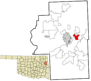
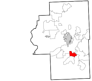
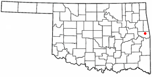
Pettit is an unincorporated community and census-designated place (CDP) in Cherokee County, Oklahoma, United States. The population was 954 at the 2010 census, a 23.7 percent increase over the figure of 771 recorded in 2000. The town was named for Mark and Eliza Pettit, townsite allottees.

<span class="mw-page-title-main">Shady Grove, Cherokee County, Oklahoma</span> Census-designated place in Oklahoma, United States

Shady Grove is an unincorporated community and census-designated place (CDP) in Cherokee County, Oklahoma, United States. The population was 556 at the 2010 census. This is not to be confused with the similarly-named Shady Grove in McIntosh County, or the Shady Grove in Pawnee County.

<span class="mw-page-title-main">Welling, Oklahoma</span> Census-designated place in Oklahoma, United States

Welling is an unincorporated community and census-designated place (CDP) in Cherokee County, Oklahoma, United States. The population was 771 at the 2010 census, an increase of 15.25 percent over the figure of 669 recorded in 2000. It is home to The Salvation Army's Heart o' Hills camp and conference center.

<span class="mw-page-title-main">Woodall, Oklahoma</span> Census-designated place in Oklahoma, United States

Woodall is an unincorporated community and census-designated place (CDP) in Cherokee County, Oklahoma, United States. The population was 823 at the 2010 census.

<span class="mw-page-title-main">Zeb, Oklahoma</span> Census-designated place in Oklahoma, United States

Zeb is an unincorporated community and census-designated place (CDP) in Cherokee County, Oklahoma, United States. The population was 497 at the 2010 census.

Copeland is an unincorporated community and census-designated place (CDP) in Delaware County, Oklahoma, United States. The population was 1,629 at the 2010 census, a 12.5 percent increase from the figure of 1,448 recorded in 2000. Founded as a railroad community, it was named for local resident D.R. Copeland.

Rocky Ford is a census-designated place (CDP) in Delaware and Cherokee counties, Oklahoma, United States. The population was 61 at the 2010 census.

<span class="mw-page-title-main">Bushyhead, Oklahoma</span> CDP in Oklahoma, United States

Bushyhead is a census-designated place (CDP) in Rogers County, Oklahoma, United States. The population was 1,314 at the 2010 census, a 9.2 percent increase over the figure of 1,203 recorded in 2000. Established on the St. Louis-San Francisco Railway between Claremore and Vinita, the community was named for Dennis W. Bushyhead, Principal Chief of the Cherokee, 1879–1887. The post office existed from April 18, 1898, until November 15, 1955.

<span class="mw-page-title-main">Brushy, Oklahoma</span> CDP in Oklahoma, United States

Brushy is a census-designated place (CDP) in Sequoyah County, Oklahoma, United States, along U.S. Route 59 in the foothills of the Brushy Mountains. It is part of the Fort Smith, Arkansas-Oklahoma Metropolitan Statistical Area. The population was 900 at the 2010 census, an increase of 14.4 percent over the figure of 787 recorded in 2000.

Dwight Mission is a census-designated place (CDP) in Sequoyah County, Oklahoma, United States. It is part of the Fort Smith, Arkansas-Oklahoma Metropolitan Statistical Area. The population was 55 at the 2010 census, a 71.9 percent gain over the figure of 32 recorded in 2000. It is currently the home of Dwight Mission Presbyterian Camp & Retreat Center.

<span class="mw-page-title-main">Long, Oklahoma</span> CDP in Oklahoma, United States

Long is a census-designated place (CDP) in Sequoyah County, Oklahoma, United States. It is part of the Fort Smith, Arkansas-Oklahoma Metropolitan Statistical Area. The population was 363 at the 2000 census.

Redbird Smith is a census-designated place (CDP) in Sequoyah County, Oklahoma, United States. It is part of the Fort Smith, Arkansas-Oklahoma Metropolitan Statistical Area. The population was 411 at the 2000 census. It was named for Redbird Smith (Cherokee), who founded the Keetoowah Nighthawk Society in Indian Territory and established a ceremonial ground here for sacred rituals.

<span class="mw-page-title-main">Sparrowhawk, Oklahoma</span> Census-designated place in Oklahoma, United States

Sparrowhawk is an unincorporated community and census-designated place (CDP) in Cherokee County, Oklahoma, United States. The population was 191 as of the 2010 census, at which time the CDP was known as Scraper. The older name of the community was given for Captain Archibald Scraper of the 2nd Regiment, Indian Home Guard. Sparrowhawk takes its name from Sparrow Hawk Mountain, which occupies most of the CDP.

References

  1. "ArcGIS REST Services Directory". United States Census Bureau. Retrieved September 20, 2022.
  2. 1 2 3 U.S. Geological Survey Geographic Names Information System: Tenkiller, Oklahoma
  3. 1 2 "U.S. Census website". United States Census Bureau . Retrieved January 31, 2008.
  4. 1 2 "Geographic Identifiers: 2010 Demographic Profile Data (G001): Tenkiller CDP, Oklahoma". U.S. Census Bureau, American Factfinder. Archived from the original on February 19, 2015. Retrieved February 19, 2015.
  5. "Census of Population and Housing". Census.gov. Retrieved June 4, 2016.