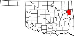
Pettit, Oklahoma | |
---|---|
Coordinates: 35°45′21″N95°00′30″W / 35.75583°N 95.00833°W | |
Country | United States |
State | Oklahoma |
County | Cherokee |
Area | |
• Total | 11.23 sq mi (29.09 km2) |
• Land | 11.22 sq mi (29.05 km2) |
• Water | 0.01 sq mi (0.04 km2) |
Elevation | 715 ft (218 m) |
Population (2020) | |
• Total | 829 |
• Density | 73.91/sq mi (28.54/km2) |
Time zone | UTC-6 (Central (CST)) |
• Summer (DST) | UTC-5 (CDT) |
ZIP code | 74451 |
Area code(s) | 539/918 |
FIPS code | 40-58400 [3] |
GNIS feature ID | 2409058 [2] |
Pettit is an unincorporated community and census-designated place (CDP) in Cherokee County, Oklahoma, United States. [2] The population was 954 at the 2010 census, a 23.7 percent increase over the figure of 771 recorded in 2000. [4] The town was named for Mark and Eliza Pettit, townsite allottees. [5]
According to the United States Census Bureau, the CDP has a total area of 11.6 square miles (30 km2), all land.
The community borders Lake Tenkiller on the southeast, and Pettit Bay Public Use Area is across the lake arm from Pettit. [6]
Census | Pop. | Note | %± |
---|---|---|---|
2020 | 829 | — | |
U.S. Decennial Census [7] |
As of the census [3] of 2000, there were 771 people, 329 households, and 227 families residing in the CDP. The population density was 66.6 inhabitants per square mile (25.7/km2). There were 459 housing units at an average density of 39.7 per square mile (15.3/km2). The racial makeup of the CDP was 64.46% White, 0.13% African American, 24.38% Native American, 0.13% from other races, and 10.89% from two or more races. Hispanic or Latino of any race were 1.04% of the population.
There were 329 households, out of which 27.7% had children under the age of 18 living with them, 57.1% were married couples living together, 8.5% had a female householder with no husband present, and 31.0% were non-families. 27.1% of all households were made up of individuals, and 10.6% had someone living alone who was 65 years of age or older. The average household size was 2.34 and the average family size was 2.84.
In the CDP, the population was spread out, with 22.7% under the age of 18, 6.2% from 18 to 24, 25.9% from 25 to 44, 28.1% from 45 to 64, and 17.0% who were 65 years of age or older. The median age was 42 years. For every 100 females, there were 104.5 males. For every 100 females age 18 and over, there were 104.8 males.
The median income for a household in the CDP was $25,766, and the median income for a family was $26,806. Males had a median income of $25,536 versus $21,250 for females. The per capita income for the CDP was $14,432. About 12.7% of families and 15.3% of the population were below the poverty line, including 20.5% of those under age 18 and 8.9% of those age 65 or over.
Evaro is a census-designated place (CDP) in Missoula County, Montana, United States, and part of the Missoula Metropolitan Statistical Area. It is located on the southernmost tip of the Flathead Indian Reservation, approximately 12 miles (19 km) north of downtown Missoula and is served by US Highway 93. In 2010, Evaro had a population of 322, a decrease from 329 in 2000.
Cherry Tree is a census-designated place (CDP) in Adair County, Oklahoma, United States. The population was 883 at the 2010 census, a decline of 26.5 percent from the figure of 1,202 recorded in 2000.
Chewey is a census-designated place (CDP) in Adair County, Oklahoma, United States. The population was 135 at the 2010 census.
Christie is a census-designated place (CDP) in Adair County, Oklahoma, United States. The population was 218 at the 2010 census, a 31.3 percent increase over the figure of 166 recorded in 2000.
Lyons Switch is a census-designated place (CDP) in Adair County, Oklahoma, United States. The population was 288 at the 2010 census.
Peavine is a census-designated place (CDP) in Adair County, Oklahoma, United States. The population was 423 at the 2010 census.
Welling is an unincorporated community and census-designated place (CDP) in Cherokee County, Oklahoma, United States. The population was 771 at the 2010 census, an increase of 15.25 percent over the figure of 669 recorded in 2000. It is home to The Salvation Army's Heart o' Hills camp and conference center.
Dennis is an unincorporated community and census-designated place (CDP) in Delaware County, Oklahoma, near Grand Lake. The population was 195 at the 2010 census. The Dennis Post Office existed from March 25, 1914, until January 31, 1956. It is said to be named for a local resident, Peter Dennis.
Flint Creek is an unincorporated area and census-designated place (CDP) in Delaware County, Oklahoma, United States. The population was 732 at the 2010 census, up from 580 in 2000.
Rocky Ford is a census-designated place (CDP) in Delaware and Cherokee counties, Oklahoma, United States. The population was 61 at the 2010 census.
Bushyhead is a census-designated place (CDP) in Rogers County, Oklahoma, United States. The population was 1,314 at the 2010 census, a 9.2 percent increase over the figure of 1,203 recorded in 2000. Established on the St. Louis-San Francisco Railway between Claremore and Vinita, the community was named for Dennis W. Bushyhead, Principal Chief of the Cherokee, 1879–1887. The post office existed from April 18, 1898, until November 15, 1955.
Limestone is a census-designated place (CDP) in Rogers County, Oklahoma, United States, at an elevation of 705 feet. It is located less than 10 miles west of Claremore, Oklahoma on Oklahoma State Highway 20. The population was 753 as of July 2020.
Brushy is a census-designated place (CDP) in Sequoyah County, Oklahoma, United States, along U.S. Route 59 in the foothills of the Brushy Mountains. It is part of the Fort Smith, Arkansas-Oklahoma Metropolitan Statistical Area. The population was 900 at the 2010 census, an increase of 14.4 percent over the figure of 787 recorded in 2000.
Marble City Community is a census-designated place (CDP) in Sequoyah County, Oklahoma, United States. It is part of the Fort Smith, Arkansas-Oklahoma Metropolitan Statistical Area. The population was 420 at the 2000 census.
Notchietown is a census-designated place (CDP) in Sequoyah County, Oklahoma, United States. It is part of the Fort Smith, Arkansas-Oklahoma Metropolitan Statistical Area. The population was 430 at the 2000 census.
Short is a census-designated place (CDP) in Sequoyah County, Oklahoma, United States. It is part of the Fort Smith, Arkansas-Oklahoma Metropolitan Statistical Area. The population was 328 at the 2000 census.
Stony Point is a census-designated place (CDP) in Sequoyah County, Oklahoma, United States. It is part of the Fort Smith, Arkansas-Oklahoma Metropolitan Statistical Area. The population was 177 at the 2000 census.
Sycamore is a census-designated place (CDP) in Sequoyah County, Oklahoma, United States. It is part of the Fort Smith, Arkansas-Oklahoma Metropolitan Statistical Area. The population was 150 at the 2000 census.
Altamont is a census-designated place (CDP) in Schuylkill County, Pennsylvania, United States. The population was 2,689 at the 2000 census.
Lac du Flambeau is a census-designated place (CDP) in the town of Lac du Flambeau in Vilas County, Wisconsin, United States. The population was 1,845 at the 2020 census. Lac du Flambeau is the major community for the Lac du Flambeau Band of Lake Superior Chippewa tribe.