Pumpkin Hollow, Oklahoma

Last updated

Pumpkin Hollow, Oklahoma
USA Oklahoma location map.svg
Red pog.svg
Pumpkin Hollow
Usa edcp location map.svg
Red pog.svg
Pumpkin Hollow
Coordinates: 35°59′01″N94°50′57″W / 35.98361°N 94.84917°W / 35.98361; -94.84917
CountryUnited States
State Oklahoma
County Cherokee
Area
[1]
  Total14.79 sq mi (38.29 km2)
  Land14.72 sq mi (38.14 km2)
  Water0.06 sq mi (0.16 km2)
Elevation
[2]
991 ft (302 m)
Population
 (2020)
  Total176
  Density11.95/sq mi (4.61/km2)
Time zone UTC-6 (Central (CST))
  Summer (DST) UTC-5 (CDT)
ZIP Codes
74464 (Tahlequah)
74457 (Proctor)
Area code(s) 918/539
FIPS code 40-61113
GNIS feature ID2807004 [2]

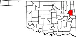
Pumpkin Hollow is a census-designated place (CDP) in Cherokee County, Oklahoma, United States, within the Cherokee Nation. It was first listed as a CDP prior to the 2020 census. [2]

The CDP is in eastern Cherokee County, bordered to the east by Adair County, to the northwest by Tully Hollow, and to the southwest by the Illinois River, across which is the CDP of Sparrowhawk. Pumpkin Hollow is the main valley in the community, running from the northeast to the southwest end.

By road, the community is 9 miles (14 km) northeast of Tahlequah, the county seat.

Demographics

Historical population
CensusPop.Note
2020 176
U.S. Decennial Census [3]

Related Research Articles

<span class="mw-page-title-main">Cherokee County, Oklahoma</span> County in Oklahoma, United States

Cherokee County is a county located in the U.S. state of Oklahoma. As of the 2020 census, the population was 47,078. Its county seat is Tahlequah, which is also the capital of the Cherokee Nation.

<span class="mw-page-title-main">Dry Creek, Oklahoma</span> Census-designated place in Oklahoma, United States

Dry Creek is an unincorporated community and census-designated place (CDP) in Cherokee County, Oklahoma, United States. The population was 227 at the 2010 census.

<span class="mw-page-title-main">Park Hill, Oklahoma</span> Census-designated place in Oklahoma, United States

Park Hill is an unincorporated community and census-designated place (CDP) in southwestern Cherokee County, Oklahoma, United States. The population was 3,909 at the 2010 census. It lies near Tahlequah, east of the junction of U.S. Route 62 and State Highway 82.

<span class="mw-page-title-main">Shady Grove, Cherokee County, Oklahoma</span> Census-designated place in Oklahoma, United States

Shady Grove is an unincorporated community and census-designated place (CDP) in Cherokee County, Oklahoma, United States. The population was 556 at the 2010 census. This is not to be confused with the similarly-named Shady Grove in McIntosh County, or the Shady Grove in Pawnee County.

<span class="mw-page-title-main">Woodall, Oklahoma</span> Census-designated place in Oklahoma, United States

Woodall is an unincorporated community and census-designated place (CDP) in Cherokee County, Oklahoma, United States. The population was 823 at the 2010 census.

<span class="mw-page-title-main">Riverton, Kansas</span> Unincorporated community in Cherokee County, Kansas

Riverton is an unincorporated community in Cherokee County, Kansas, United States. As of the 2020 census, the population of the community and nearby areas was 771. It is located at the junction of K-66 and U.S. Route 69 Alternate and U.S. Route 400, near the Spring River. It is one of only three communities in Kansas along former U.S. Route 66.

<span class="mw-page-title-main">Sparrowhawk, Oklahoma</span> Census-designated place in Oklahoma, United States

Sparrowhawk is an unincorporated community and census-designated place (CDP) in Cherokee County, Oklahoma, United States. The population was 191 as of the 2010 census, at which time the CDP was known as Scraper. The older name of the community was given for Captain Archibald Scraper of the 2nd Regiment, Indian Home Guard. Sparrowhawk takes its name from Sparrow Hawk Mountain, which occupies most of the CDP.

Pumpkin Center is an unincorporated community in Muskogee County, Oklahoma, United States. It is about 14 miles east of the city of Muskogee.

Pumpkin Center is an unincorporated community in Okmulgee County, Oklahoma, United States. It is approximately 10 miles northeast of the city of Okmulgee, taking N 330 Rd. north off US Highway 62.

Pumpkin Center is an unincorporated community in Comanche County, Oklahoma, United States. It is located at the intersection of state highways 7 and 65, approximately 10 miles east of Lawton in the southwestern portion of the state.

Steely Hollow is an unincorporated area and census-designated place (CDP) in Cherokee County, Oklahoma, United States. The population was 206 at the 2010 census.

Cave Spring is a census-designated place (CDP) in Adair County, Oklahoma, United States. Part of the Cherokee Nation, it was first listed as a CDP prior to the 2020 census.

Barber is an unincorporated community and census-designated place (CDP) in Cherokee County, Oklahoma, United States, in the Cherokee Nation. It was first listed as a CDP prior to the 2020 census.

Caney is a census-designated place (CDP) in Cherokee County, Oklahoma, United States, within the Cherokee Nation. It was first listed as a CDP prior to the 2020 census. It includes the unincorporated community of Tailholt.

Caney Ridge is an unincorporated community and census-designated place (CDP) in Cherokee County, Oklahoma, United States, within the Cherokee Nation. It was first listed as a CDP prior to the 2020 census.

Etta is a census-designated place (CDP) in Cherokee County, Oklahoma, United States, within the Cherokee Nation. It was first listed as a CDP prior to the 2020 census.

Lowrey is an unincorporated community and census-designated place (CDP) in Cherokee County, Oklahoma, United States. It was first listed as a CDP prior to the 2020 census.

Norwood is a census-designated place (CDP) in Cherokee and Muskogee counties, Oklahoma, United States. It was first listed as a CDP prior to the 2020 census.

Little Rock is an unincorporated community and census-designated place (CDP) in Mayes County, Oklahoma, United States. It was first listed as a CDP prior to the 2020 census.

References

  1. "ArcGIS REST Services Directory". United States Census Bureau. Retrieved September 20, 2022.
  2. 1 2 3 U.S. Geological Survey Geographic Names Information System: Pumpkin Hollow, Oklahoma
  3. "Census of Population and Housing". Census.gov. Retrieved June 4, 2016.