Cantalupo in Sabina | |
---|---|
Comune di Cantalupo in Sabina | |
Coordinates: 42°18′N12°39′E / 42.300°N 12.650°E | |
Country | Italy |
Region | Lazio |
Province | Rieti (RI) |
Government | |
• Mayor | Paolo Rinalduzzi (since May 2014) |
Area | |
• Total | 10 km2 (4 sq mi) |
Elevation | 297 m (974 ft) |
Population (2001) [2] | |
• Total | 1,621 |
• Density | 160/km2 (420/sq mi) |
Demonym | Cantalupani |
Time zone | UTC+1 (CET) |
• Summer (DST) | UTC+2 (CEST) |
Postal code | 02040 |
Dialing code | 0765 |
Patron saint | St. Blaise |
Saint day | February 3 |
Website | Official website |
Cantalupo in Sabina (Sabino: Candalupu) is a town and comune in the province of Rieti, on the Sabine Hills of Lazio. It is famous as the reputed origin of the melon called a cantaloupe melon.
It is one of several Italian comuni named "Cantalupo" ("song of the wolf" or "howl of the wolf" or literally "sings wolf") and it seems that these place names are due to an elevated presence of wolves at the time of their naming (probably because wolves could be heard howling, but this etymology is actually disputed nowadays).
Cantalupo in Imperial Roman times housed a scattering of villas, one belonging to the Tullii, the family of the orator Marcus Tullius Cicero, but in the Migrations period the inhabitants were protected by a walled castle at the high point of a rocky spur, which was in possession of the counts of Cuneo. Cantalupo was not mentioned however, until an 11th-century register reported the walled village as a possession of the abbots of Farfa. Though in 1278 the commune's representatives swore fealty to the Papacy, its borderlands position in the marches of Lazio (governed from Rome) and Umbria, Cantalupo passed from one feudatory lord to another.
The rocca commanding the town was expanded into a residence for the counts of Sant'Eustachio in the 13th and 14th centuries, and then passed to the Savelli family in the 15th century before it was further enlarged by a series of successive holders of the feodo. The site is now privately owned. [3]
In the Papal States, Cantalupo was governed by a direct representative of the Apostolic Camera.
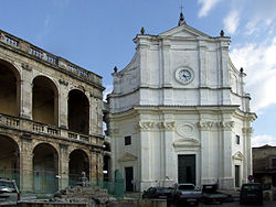
Among the landmark buildings is the baroque church of Santa Maria Assunta in Cielo.
Bevagna is a town and comune in the central part of the Italian province of Perugia (Umbria), in the flood plain of the Topino river.
Cascia is a town and comune (municipality) of the Italian province of Perugia in a rather remote area of the mountainous southeastern corner of Umbria. It is about 21 km from Norcia on the road to Rieti in the Lazio (63 km). It is also very close to Terni.
Alvito is a town and comune in central Italy, in the province of Frosinone, south of Rome in the Lazio region. Its territory is included in the Abruzzo, Lazio and Molise National Park.
Monteleone di Spoleto, is a town and comune of Italy, in the province of Perugia in southeast Umbria at 978 meters (3,209 ft) above sea-level overhanging the upper valley of the Corno River. It is one of the more remote towns in Umbria, on a mountain road from Norcia and Cascia to Leonessa and Rieti in the Lazio. It is one of I Borghi più belli d'Italia.
Fossato di Vico is a town and comune of Umbria in the province of Perugia in Italy, at 581 m above sea‑level on the middle slopes of Mount Mutali.
Paliano is a town and comune in the province of Frosinone, in the Lazio region of central Italy.
Cantalupo nel Sannio is a town and comune in the province of Isernia, in the Molise region of southern Italy.
Corciano is a comune (municipality) in the Province of Perugia in the Italian region Umbria, located about 8 km west of Perugia. As of 31 December 2004, it had a population of 17,008 and an area of 63.7 km2. Corciano borders the comuni of Magione and Perugia. It is one of I Borghi più belli d'Italia.
Montone is a comune (municipality) in the Province of Perugia in the Italian region Umbria, located about 35 km north of Perugia. It is one of I Borghi più belli d'Italia.
Monteleone d'Orvieto is a comune (municipality) in the Province of Terni in the Italian region Umbria, located about 35 km southwest of Perugia and about 60 km northwest of Terni. It is one of I Borghi più belli d'Italia.
Stroncone is a comune (municipality) in the Province of Terni in the Italian region Umbria, located about 70 km southeast of Perugia and about 8 km south of Terni. It is one of I Borghi più belli d'Italia.
Casperia is a comune (municipality) in the Province of Rieti in the Italian region of Latium, located about 50 kilometres (31 mi) northeast of Rome and about 20 kilometres (12 mi) southwest of Rieti. As of 31 December 2004, it had a population of 1,164 and an area of 25.4 square kilometres (9.8 sq mi).
Castel di Tora is a comune (municipality) in the Province of Rieti in the Italian region of Lazio, located about 50 kilometres (31 mi) northeast of Rome and about 20 kilometres (12 mi) southeast of Rieti.
Fara in Sabina is a comune (municipality) in the Province of Rieti in the Italian region of Lazio, located about 40 kilometres (25 mi) northeast of Rome and about 25 kilometres (16 mi) southwest of Rieti.
Forano is a comune (municipality) in the province of Rieti, in the Italian region of Latium, located about 45 kilometres (28 mi) north of Rome and about 25 kilometres (16 mi) southwest of Rieti. As of 31 December 2004, it had a population of 2,697 and an area of 17.5 square kilometres (6.8 sq mi).
Magliano Sabina is a comune (municipality) in the Province of Rieti in the Italian region of Latium, located about 50 kilometres (31 mi) north of Rome and about 30 kilometres (19 mi) west of Rieti. As of 31 December 2004, it had a population of 3,829 and an area of 43.7 square kilometres (16.9 sq mi).
Poggio Catino is a comune (municipality) in the Province of Rieti in the Italian region of Latium, located about 45 kilometres (28 mi) northeast of Rome and about 20 kilometres (12 mi) southwest of Rieti. As of 31 December 2011, it had a population of 1,335 and an area of 15.0 square kilometres (5.8 sq mi).
Poggio Mirteto is a comune (municipality) is situated in the Tiber Valley area of the region of Latium, Italy. Administratively Poggio Mirteto is in the province of Rieti and geographically this municipality is about 45 kilometres (28 mi) northeast of Rome and about 20 kilometres (12 mi) southwest of Rieti.
Selci is a comune (municipality) in the Province of Rieti in the Italian region of Latium, located about 45 kilometres (28 mi) north of Rome and about 25 kilometres (16 mi) southwest of Rieti. As of 31 December 2004, it had a population of 1,038 and an area of 7.8 square kilometres (3.0 sq mi).
Montelibretti is a town and comune (municipality) in the Metropolitan City of Rome in the Italian region of Lazio, located about 30 kilometres (19 mi) northeast of Rome on the slopes of Monti Sabini.