
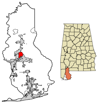
Baldwin County is a county located in the southwestern part of the U.S. state of Alabama, on the Gulf coast. It is one of only two counties in Alabama that border the Gulf of Mexico, along with Mobile County. As of the 2020 census, the population was 231,767, making it the fourth-most populous county in Alabama. The county seat is Bay Minette. The county is named after the founder of the University of Georgia, Senator Abraham Baldwin.

Bay Minette is a city in and the county seat of Baldwin County, Alabama, United States. As of the 2010 census, the population of the city was 8,044.

Daphne is a city in Baldwin County, Alabama, United States, on the eastern shoreline of Mobile Bay. The city is located along I-10, 11 miles east of Mobile and 170 miles southwest of the state capital of Montgomery. The 2020 United States Census lists the population of the city as 27,462, making Daphne the most populous city in Baldwin County. It is a principal city of the Daphne-Fairhope-Foley metropolitan area, which includes all of Baldwin County.

Loxley is a city in Baldwin County, Alabama, United States. As of the 2010 census, the population of the town was 1,632. It is part of the Daphne-Fairhope-Foley metropolitan area. Loxley is becoming a popular location for the expansion of the suburbs from Daphne and Spanish Fort, Alabama, because it is served by an Interstate 10 exit and is almost directly between the cities of Mobile, Alabama, and Pensacola, Florida.

The Perdido River, also historically known as Rio Perdido or by its native name of Cassaba, is a 65.4-mile-long (105.3 km) river in the U.S. states of Alabama and Florida; the Perdido, a designated Outstanding Florida Waters river, forms part of the boundary between the two states along nearly its entire length and drains into the Gulf of Mexico. During the early 19th century it played a central role in a series of rotating boundary changes and disputes among France, Spain, Great Britain, and the United States.

Fort Morgan is a historic masonry pentagonal bastion fort at the mouth of Mobile Bay, Alabama, United States. Named for American Revolutionary War hero Daniel Morgan, it was built on the site of the earlier Fort Bowyer, an earthen and stockade-type fortification involved in the final land battles of the War of 1812. Construction was completed in 1834, and it received its first garrison in March of the same year.

Tensaw is an unincorporated community in Baldwin County, Alabama, United States. It is part of the Daphne–Fairhope–Foley Micropolitan Statistical Area and is the home of historic Fort Mims.

The Mobile Metropolitan Area comprises Mobile in the southwest corner of Alabama in the United States. As of the 2020 census the metropolitan area had a population of 430,197. The Mobile metropolitan area is the third-largest metropolitan area in the state of Alabama, after Birmingham and Huntsville. Washington County was part of the Mobile metropolitan area but was removed when the OMB released its statistical definitions effective July 2023.
Stapleton is a small unincorporated community in northern Baldwin County, Alabama, United States, with a population of 519.. It is part of the Daphne-Fairhope-Foley metropolitan area. Stapleton lies along U.S. Route 31 and State Route 59 and has been considered for incorporation within the cities of Loxley and Bay Minette. There is a bluegrass music festival held at Stapleton Elementary School every fall. There are about 250 students at the school that runs from Pre-K to the 6th grade.

Blakeley is a ghost town in Baldwin County, Alabama, United States. During the height of its existence, Blakeley was a thriving town which flourished as a competitor to its western neighbor, Mobile. Blakeley was the county seat for Baldwin County from 1820 until 1868, when the county government was moved south to Daphne. It was the location of a major fort during the Civil War. One of the last battles of the Civil War was fought here in April 1865, as Union soldiers overran Confederates. The town is now in an Alabama historic state park known as Historic Blakeley State Park, north of Spanish Fort.
Fort Morgan, also known as Fort Bowyer, is an unincorporated community in Baldwin County, Alabama, United States. It is west of Gulf Shores on Mobile Point. Mobile Point extends from Gulf Shores to the west, towards historic Fort Morgan at the tip of the peninsula.
Harry Toulmin was a Unitarian minister and politician. The son of noted Dissenting minister Joshua Toulmin, Toulmin fled his native England for the United States after he and his followers were persecuted for their beliefs. He arrived in Virginia in 1793, and aided by recommendations from Thomas Jefferson and James Monroe, he was chosen president of Transylvania Seminary in Lexington, Kentucky. His Unitarian views, however, offended many of the orthodox Presbyterian members of Transylvania's board of regents, and Toulmin resigned after two years.

Perdido, also known as Perdido Station, is an unincorporated community and census-designated place in Baldwin County, Alabama, United States. Perdido is located along County Route 61, 12.2 miles (19.6 km) northeast of Bay Minette. Perdido has a post office with ZIP code 36562. It has an elementary school, Perdido School, which is part of the Baldwin County Board of Education.

Ira Bowman Thompson was a politician, Ku Klux Klan leader, and attorney from the U.S. state of Alabama.
Stephen Albert McMillan was an American politician and real estate broker. From 1980 until his death, he was a member of the Alabama House of Representatives representing the 95th District, first serving as a Democrat before switching to the Republican Party in 1989. He was first elected to succeed his twin brother, John McMillan. At the time of his death, he was the longest-serving member of the Alabama House of Representatives.
Bromley is an unincorporated community in Baldwin County, Alabama, United States.
Crossroads is an unincorporated community in Baldwin County, Alabama, United States. Crossroads is located on Alabama State Route 225, 5.5 miles (8.9 km) southwest of Bay Minette.
Marlow is an unincorporated community in Baldwin County, Alabama, United States.

State Route 112 (SR 112) was a 30.2-mile-long (48.6 km) state highway in the southwestern part of the U.S. state of Alabama. The western terminus of the highway was at an intersection with U.S. Route 31 (US 31) in Bay Minette. The eastern terminus of the highway was at the Florida state line, west of Muscogee, where the roadway continues as Escambia County Road 184 (CR 184).
The Baldwin Times is a twice-weekly newspaper serving the Bay Minette area in the U.S. state of Alabama. It has a current circulation of about 1,000 as of 2018.


