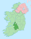
County Tipperary is a county in Ireland. It is in the province of Munster and the Southern Region. The county is named after the town of Tipperary, and was established in the early 13th century, shortly after the Norman invasion of Ireland. The population of the county was 159,553 at the 2016 census. The largest towns are Clonmel, Nenagh and Thurles.

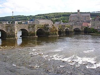
Carrick-on-Suir is a town in County Tipperary, Ireland. It lies on both banks of the River Suir. The part on the north bank of the Suir lies in the civil parish of "Carrick", in the historical barony of Iffa and Offa East. The part on the south bank lies in the civil parish of Kilmolerin in the barony of Upperthird, County Waterford.

Rathgormack or Rathgormac is a village and parish in northern County Waterford, Ireland.

Galbally is a village in southeast County Limerick, Ireland, on the border with County Tipperary. It is located at the foot of the Galtee Mountains and at the western approach to the Glen of Aherlow. The Aherlow River, flowing down from the Galtee mountains, runs by the village, to meet the Suir at Kilmoyler a short distance north of Cahir. Galbally is in a valley overlooked by the Galtee Mountains.

The N24 road is a national primary road in Ireland forming a route from Limerick to Waterford, running through County Tipperary and passing Tipperary Town, Cahir, Carrick-on-Suir and Clonmel.
Kilmoyler is a townland in the civil parish of Killardry in the barony of Clanwilliam, County Tipperary in Ireland. The townland is in the parish of 'Bansha and Kilmoyler' in the Roman Catholic Archdiocese of Cashel and Emly.
Carrick Swan GAA is a Gaelic Athletic Association club, located in the town of Carrick-on-Suir in south County Tipperary in Ireland. It is one of three GAA clubs in the town, one of which, St. Molleran's, is in County Waterford in the southern suburb of Carrickbeg. The Swan are predominantly a hurling club and lead the roll of honour for the number of South Tipperary senior hurling championships won. The club enjoys a keen rivalry with the longer established Carrick Davins, named in honour of Maurice Davin, first President of the GAA who lived at Deerpark near the town. They have one of the best setups for underage youngsters in the county with numerous county titles been won underage. The Swans' most famous players were the Wall brothers, Willie and Tom who played with distinction for Tipperary in the 1940s.

Mooncoin is a census town in County Kilkenny, in Ireland. The population was 1,175 in 2016. Historically part of the Gaelic kingdom of Osraige, today it is in the far south of the county of Kilkenny, located in the valley of the River Suir. It is surrounded by the uplands of the Slievenamon and Comeragh Mountains, just 10 kilometres (6.2 mi) north of Waterford City along the N24 national primary road, and it is 48 kilometres (30 mi) south of Kilkenny.

Irish Catholic Martyrs were 22 people who have been sanctified in varying degrees for dying for their Roman Catholic faith between 1537 and 1681 in Ireland. The canonisation of Oliver Plunkett in 1975 brought an awareness of the other men and women who died for the Catholic faith in the 16th and 17th centuries. On 22 September 1992 Pope John Paul II proclaimed a representative group from Ireland as martyrs and beatified them. "Martyr" was originally a Greek word meaning "witness". In the Acts of the Apostles, Peter, speaking to those in Jerusalem at Pentecost, claimed he and all the apostles were "martyrs", that is, witnesses, in this case to Jesus's resurrection. Later the word came to mean a person who followed the example of Christ and gave up their lives rather than deny their faith.

Kilsheelan is a village and civil parish within the in the barony of Iffa and Offa East in County Tipperary, Ireland. It is also one half of the Roman Catholic parish of Kilsheelan & Kilcash in the Roman Catholic Diocese of Waterford and Lismore.
Events from the year 1336 in Ireland.

Kilculliheen is a civil parish, electoral division and barony in Ireland, on the north bank of the River Suir across from the centre of Waterford City. Historically, it has been transferred several times between the county of the city of Waterford and the counties of Kilkenny and Waterford. It now contains the only part of Waterford city on the left bank of the River Suir. The Parliamentary Gazetteer of 1846 states "as it lies on the left bank of the Suir, which, for the most part, divides co. Waterford from co. Kilkenny, most topographists mistakingly assign it to the barony of Ida, co. Kilkenny". It is now partly in County Kilkenny and partly in Waterford City. Of the barony's eleven townlands, five are entirely in Kilkenny and six are split between Kilkenny and Waterford. The city portion contains the former village of Ferrybank, which gives its name to a wider suburb which has spread across the county boundary.
Carrick Davins GAA is a Gaelic Athletic Association club located in the town of Carrick-on-Suir in south County Tipperary in Ireland. It is one of three GAA clubs in the town, one of which, St Molleran's, is in County Waterford in the southern suburb of Carrickbeg across the River Suir. The club plays both hurling and Gaelic football but is predominantly a hurling club. The club enjoys a keen rivalry with Carrick Swans GAA. The club is named in honour of Maurice Davin, the first President of the GAA, who lived near the town.
The East Munster Way, formerly known as the Munster Way, is a long-distance trail in Ireland. It is 75 kilometres long and begins in Carrick-on-Suir, County Tipperary and ends in Clogheen, County Tipperary. It is typically completed in three days. It is designated as a National Waymarked Trail by the National Trails Office of the Irish Sports Council and is managed by Tipperary County Council, Coillte and Waterford County Council. The trail was opened by Frank Fahey, Minister of State for Youth and Sport in July 1988.
Tybroughney, statutory spelling Tibberaghny, is a civil parish in the barony of Iverk, County Kilkenny in Ireland. The parish comprises a single townland, also called Tibberaghny. It lies on the north bank of the River Suir facing County Waterford, while the Lingaun river separates it from County Tipperary to the west.

Iverk is a barony in the south-west of County Kilkenny, Ireland. The size of the barony is 167.3 square kilometres (64.6 sq mi). There are 15 civil parishes in Iverk. The chief town today is Piltown. The N24 crosses the barony.

Carrick is a village located within the civil parish of Glencolmcille in County Donegal, Ireland. As of the 2016 census, the population of the village was 265. Carrick is located between neighbouring towns Glencolmcille, Meenanary, Teelin and Kilcar. Nearby is Sliabh Liag, the highest sea cliff in Europe.

Upperthird or Upper Third is a barony in County Waterford, Republic of Ireland.

The R676 road is a regional road in Ireland. It connects the N25 road in County Waterford to the N24 at Carrick-on-Suir, County Tipperary, via the villages of Mahon Bridge and Carrickbeg. The road is 23.9 kilometres (14.9 mi) long.


