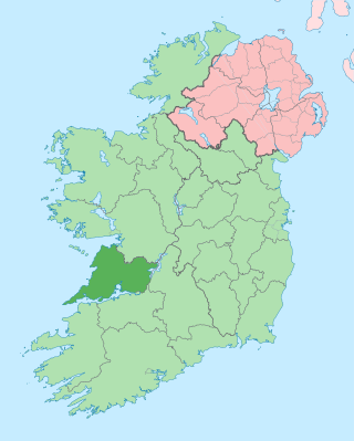
County Clare is a county in Ireland, in the Southern Region and the province of Munster, bordered on the west by the Atlantic Ocean. Clare County Council is the local authority. The county had a population of 127,938 at the 2022 census. The county seat and largest settlement is Ennis.

Dromineer is a small village and townland in County Tipperary, Ireland. It is situated on the shores of Lough Derg on the River Shannon. The village is located 10 km north of Nenagh on the R495 road. It is a civil parish in the historical barony of Ormond Lower. Historic documents describe the places as "Dromynnyre"; the earliest form of the name dating from 1302 was Dromynwyr.

Roscrea is a market town in County Tipperary, Ireland, which in 2016 had a population of 5,446. Roscrea is one of the oldest towns in Ireland, having developed around the 7th century monastery of Saint Crónán of Roscrea, parts of which remain preserved today.

Cashel is a town in County Tipperary in Ireland. Its population was 4,422 in the 2016 census. The town gives its name to the ecclesiastical province of Cashel. Additionally, the cathedra of the Roman Catholic Archdiocese of Cashel and Emly was originally in the town prior to the English Reformation. It is part of the parish of Cashel and Rosegreen in the same archdiocese. One of the six cathedrals of the Anglican Bishop of Cashel and Ossory, who currently resides in Kilkenny, is located in the town. It is in the civil parish of St. Patricksrock which is in the historical barony of Middle Third.

Abbeyfeale is a historic market town in County Limerick, Ireland, near the border with County Kerry. The town is on the N21 road from Limerick to Tralee, some 21 kilometres south-west of Newcastle West and 16 kilometres south-east of Listowel and 38 kilometres north-east of Tralee.

Silvermines, historically known as Bellagowan, is a village in County Tipperary in Ireland. It lies immediately north of the Silvermine mountain range and takes its name from the extensive mines of lead, zinc, copper, baryte and silver nearby. Towards the very south of the Silvermine Mountains is the highest peak in the mountains, Keeper Hill or in Irish Sliabh Cimeálta, which rises to 695m, dominating the area. Silvermines is located near the town of Nenagh on the R499 regional road. It is a parish in the Roman Catholic Diocese of Killaloe and is also in the historical barony of Ormond Upper.

Cloughjordan, officially Cloghjordan, is a town in County Tipperary in Ireland. It is in the barony of Ormond Lower, and it is also a parish in the Roman Catholic Diocese of Killaloe.
Laghy or Laghey is a village and townland in County Donegal, Ireland, between Ballintra and Donegal Town. It is one of three villages that make up the parish of Drumholm, formerly a civil and Church of Ireland parish, now only used as a division of the Roman Catholic Diocese of Raphoe. The village has a quarry, a supermarket, garden centre, filling station, two public houses, a church with a graveyard, an Orange hall, a recycling centre, a Donegal County Council yard and salt depot, and a national school. Rossnowlagh and Murvagh beaches are nearby. Murvagh is also the home to Donegal Golf Club.
Raharney is a village in east County Westmeath, Ireland. It has a population of 221 according to the 2016 census.
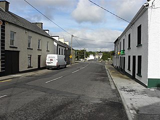
Cooraclare is a village near Kilrush, in County Clare, Ireland, and a Catholic parish by the same name.

Ballycommon is a village and townland in County Tipperary, Ireland. Around 5 km along the R495 road north-west of Nenagh, it is in the barony of Ormond Lower and part of the parish of Puckane in the Roman Catholic Diocese of Killaloe.

Moneygall is a small village on the border of counties Offaly and Tipperary, in Ireland. It is situated on the R445 road between Dublin and Limerick. There were 313 people living in the village as of the 2016 census. Moneygall has a Catholic church, motorway service station, a car sales and repair centre, a national school, a Garda station and two pubs. The nearest Church of Ireland church, Borrisnafarney, is 2 km from the village beside the former Loughton Demesne.
Birdhill is a village in County Tipperary, Ireland. It is in the barony of Owney and Arra and is part of the parish of Newport, Birdhill and Toor in the Roman Catholic Archdiocese of Cashel and Emly. Its Irish name was historically anglicised as Knockan or Knockaneeneen.

Toomevara, officially Toomyvara, is a village in County Tipperary, Ireland. The village is at the junction on the R445 where it meets the R499 regional road. The village was bypassed in December 2010 by the M7 Dublin - Limerick motorway. It is also a parish in the Roman Catholic Diocese of Killaloe, and is in the historical barony of Ormond Upper.

Portroe is a village in County Tipperary, Ireland. The village is located on the R494 regional road, 3 km from the eastern shore of Lough Derg and 10 km west of the town of Nenagh. Portroe spans the townlands of Garrykennedy, Glencrue and Shesharoe.
Newtown is a town in County Tipperary, Ireland. It is located on the R494 regional road 7 km (4.3 mi) west of Nenagh. As of the 2016 census, the population was 309. It is in the barony of Owney and Arra. It is also part of the parish of Youghalarra in the Roman Catholic Diocese of Killaloe.

Bannow is a village and civil parish lying east of Bannow Bay on the south-west coast of County Wexford, Ireland. In modern times the main settlement is the village of Carrig-on-Bannow. In Norman times there was a borough called Bannow on Bannow Island at the mouth of the Bay. This town has since disappeared, probably due to the silting up of the natural harbour channels in the 14th century, and the former island is now attached to the rest of the parish.

Doonbeg is a village in west County Clare, Ireland on the Atlantic coast. The surrounding natural environment has supported its development as a tourist resort. The area was officially classified as part of the West Clare Gaeltacht, an Irish-speaking community, until 1956.
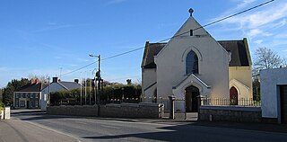
Clonlara, officially Cloonlara, is a village in County Clare, Ireland, and a Roman Catholic parish of the same name.
Crusheen is a small village in County Clare, Ireland, in the civil parish of Crusheen (Inchicronan).