Carter, Montana

Last updated

Carter, Montana
Chouteau County Montana Incorporated and Unincorporated areas Carter Highlighted.svg
Location of Carter, Montana
Coordinates: 47°46′53″N110°57′21″W / 47.78139°N 110.95583°W / 47.78139; -110.95583
Country United States
State Montana
County Chouteau
Area
[1]
  Total2.90 sq mi (7.51 km2)
  Land2.90 sq mi (7.51 km2)
  Water0.00 sq mi (0.00 km2)
Elevation
3,123 ft (952 m)
Population
 (2020)
  Total65
  Density22.43/sq mi (8.66/km2)
Time zone UTC-7 (Mountain (MST))
  Summer (DST) UTC-6 (MDT)
ZIP code
59420
Area code 406
FIPS code 30-12625
GNIS feature ID0769624

Carter is a census-designated place (CDP) in Chouteau County, Montana, United States. The population was 58 at the 2010 census. [2]

Contents

Carter's name was changed from Sidney in 1905 to honor Thomas H. Carter, the state's first congressional representative. [3]

Geography

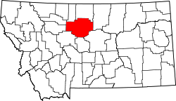
Carter is located in western Chouteau County at 47°46′53″N110°57′21″W / 47.781252°N 110.955800°W / 47.781252; -110.955800 (47.781252, -110.955800). [4] It is along U.S. Route 87, which leads northeast 14 miles (23 km) to Fort Benton, the county seat, and southwest 26 miles (42 km) to Great Falls.

According to the United States Census Bureau, the CDP has a total area of 2.9 square miles (7.5 km2), of which 0.004 square miles (0.01 km2), or 0.14%, is water. [2]

Climate

According to the Köppen Climate Classification system, Carter has a semi-arid climate, abbreviated "BSk" on climate maps. [5]

Demographics

Historical population
CensusPop.Note
2020 65
U.S. Decennial Census [6]

As of the census [7] of 2000, there were 62 people, 31 households, and 19 families residing in the CDP. The population density was 21.3 inhabitants per square mile (8.2/km2). There were 34 housing units at an average density of 11.7 per square mile (4.5/km2). The racial makeup of the CDP was 100.00% White.

There were 31 households, out of which 12.9% had children under the age of 18 living with them, 58.1% were married couples living together, 3.2% had a female householder with no husband present, and 38.7% were non-families. 32.3% of all households were made up of individuals, and 12.9% had someone living alone who was 65 years of age or older. The average household size was 2.00 and the average family size was 2.42.

In the CDP, the population was spread out, with 12.9% under the age of 18, 4.8% from 18 to 24, 27.4% from 25 to 44, 30.6% from 45 to 64, and 24.2% who were 65 years of age or older. The median age was 47 years. For every 100 females, there were 100.0 males. For every 100 females age 18 and over, there were 116.0 males.

The median income for a household in the CDP was $24,583, and the median income for a family was $33,125. Males had a median income of $16,250 versus $23,125 for females. The per capita income for the CDP was $19,397. There were 9.5% of families and 13.4% of the population living below the poverty line, including 33.3% of under eighteens and 12.0% of those over 64.

Hall of Fame

The Carter, Montana Hall of Fame honors celebrities who have visited the city. As of 2010, there were seven inductees, including Keanu Reeves, Arsenio Hall, Charlie Sheen, Eddie Vedder, Steve Smith and Harry Truman. Professional wrestler CM Punk was inducted into the Hall of Fame on May 15, 2010.[ citation needed ]

Related Research Articles

<span class="mw-page-title-main">Chouteau County, Montana</span> County in Montana, United States

Chouteau County is a county located in the North-Central region of the U.S. state of Montana. As of the 2020 census, the population was 5,895. Its county seat is Fort Benton. The county was established in 1865 as one of the original nine counties of Montana, and named in 1882 after Pierre Chouteau Jr., a fur trader who established a trading post that became Fort Benton, which was once an important port on the Missouri River.

<span class="mw-page-title-main">Black Eagle, Montana</span> CDP in Montana, United States

Black Eagle is a census-designated place (CDP) in Cascade County, Montana, United States. The population was 904 at the 2010 census. It is a suburb of Great Falls.

<span class="mw-page-title-main">Sun Prairie, Montana</span> CDP in Montana, United States

Sun Prairie is a census-designated place (CDP) in Cascade County, Montana, United States. The population was 1,630 at the 2010 census. It is part of the Great Falls Metropolitan Statistical Area and may have evolved as a remote suburb of Great Falls.

<span class="mw-page-title-main">Ulm, Montana</span> CDP in Montana, United States

Ulm is a census-designated place (CDP) in Cascade County, Montana, United States. It was originally a large ranch owned by Indiana-born cattleman William Ulm. The population was 738 at the 2010 census. It is part of the Great Falls, Montana Metropolitan Statistical Area. The Zip Code is 59485.

<span class="mw-page-title-main">Vaughn, Montana</span> CDP in Montana, United States

Vaughn is a census-designated place (CDP) in Cascade County, Montana, United States. The population was 658 at the 2010 census. It is part of the Great Falls, Montana Metropolitan Statistical Area. It is named for Montana pioneer Robert Vaughn, whose homestead on the Vaughn Ranch encompassed part of the town.

<span class="mw-page-title-main">Boneau, Montana</span> Census-designated place in Montana, United States

Boneau is a census-designated place (CDP) in Chouteau County, Montana, United States. The population was 380 at the 2010 census, up from 190 in 2000.

<span class="mw-page-title-main">Geraldine, Montana</span> Town in Montana, United States

Geraldine is a town in Chouteau County, Montana, United States. The population was 207 at the 2020 census. The area around the town is an agricultural, largely wheat-producing, region.

<span class="mw-page-title-main">Highwood, Montana</span> Census-designated place in Montana, United States

Highwood is an unincorporated community and census-designated place (CDP) in Chouteau County, Montana, United States. The population was 176 at the 2010 census.

<span class="mw-page-title-main">Loma, Montana</span> Census-designated place in Montana, United States

Loma is a census-designated place (CDP) in Chouteau County, Montana, United States. The population was 85 at the 2010 census.

<span class="mw-page-title-main">Kremlin, Montana</span> Census-designated place in Montana, United States

Kremlin is an unincorporated community and census-designated place (CDP) in Hill County, Montana, United States. The population was 98 at the 2010 census, down from 126 in 2000.

<span class="mw-page-title-main">St. Pierre, Montana</span> Census-designated place in Montana, United States

St. Pierre is a census-designated place (CDP) in Hill County, Montana, United States, within the Rocky Boy Indian Reservation. The population of St. Pierre was 350 at the 2010 census, up from 289 in 2000.

<span class="mw-page-title-main">Big Arm, Montana</span> Census-designated place in Montana, United States

Big Arm is a census-designated place (CDP) in Lake County, Montana, United States. The population was 177 at the 2010 census, up from 131 in 2000.

<span class="mw-page-title-main">Elmo, Montana</span> Census-designated place in Montana, United States

Elmo is a census-designated place (CDP) in Lake County, Montana, United States. The population was 180 at the 2010 census, up from 143 in 2000.

<span class="mw-page-title-main">Alder, Montana</span> Census-designated place in Montana, United States

Alder is a census-designated place (CDP) in Madison County, Montana, United States. The population was 86 at the 2020 census. The community takes its name from Alder Creek, the site of the second major gold discovery in Montana.

<span class="mw-page-title-main">Evaro, Montana</span> CDP in Montana, United States

Evaro is a census-designated place (CDP) in Missoula County, Montana, United States, and part of the Missoula Metropolitan Statistical Area. It is located on the southernmost tip of the Flathead Indian Reservation, approximately 12 miles (19 km) north of downtown Missoula and is served by US Highway 93. In 2010, Evaro had a population of 322, a decrease from 329 in 2000.

<span class="mw-page-title-main">Ovando, Montana</span> CDP in Montana, United States

Ovando is a census-designated place (CDP) in Powell County, Montana, United States. It is approximately fifty-four miles ENE of Missoula, Montana. The population was 71 at the 2000 census.

<span class="mw-page-title-main">Lonepine, Montana</span> CDP in Montana, United States

Lonepine is a census-designated place (CDP) in Sanders County, Montana, United States. The population was 137 at the 2000 census.

Box Elder is an unincorporated community and census-designated place (CDP) in Hill County in the U.S. state of Montana. The population was 87 at the 2010 census. The population was 794 at the 2000 census, but before 2010 the Box Elder CDP was split into the current much-smaller Box Elder CDP, while most of the former CDP area went into the new Rocky Boy West CDP. Box Elder is the headquarters of the Chippewa-Cree tribe.

<span class="mw-page-title-main">Parker School, Montana</span> Census-designated place in Montana, United States

Parker School is a census-designated place (CDP) in Hill and Chouteau counties in the U.S. state of Montana. The population was 340 at the 2010 census.

<span class="mw-page-title-main">Power, Montana</span> CDP in Montana, United States

Power is a census-designated place (CDP) in Teton County, Montana, United States. The population was 171 at the 2000 census. The town is named after Montana pioneer, Thomas Charles Power, who platted the townsite in 1910.

References

  1. "ArcGIS REST Services Directory". United States Census Bureau. Retrieved September 5, 2022.
  2. 1 2 "Geographic Identifiers: 2010 Demographic Profile Data (G001): Carter CDP, Montana". U.S. Census Bureau, American Factfinder. Archived from the original on February 12, 2020. Retrieved October 9, 2014.
  3. "Carter". Montana Place Names Companion. Montana Historical Society. Retrieved April 2, 2021.
  4. "US Gazetteer files: 2010, 2000, and 1990". United States Census Bureau. February 12, 2011. Retrieved April 23, 2011.
  5. Climate Summary for Carter, Montana
  6. "Census of Population and Housing". Census.gov. Retrieved June 4, 2016.
  7. "U.S. Census website". United States Census Bureau . Retrieved January 31, 2008.