
Castellum Tingitii, also called Castellum Tingitanum, was a Roman colonia in Mauretania Caesariensis, and corresponds to present-day Chlef in Algeria.
Castellum Tingitii, also called Castellum Tingitanum, was a Roman colonia in Mauretania Caesariensis, and corresponds to present-day Chlef in Algeria.
Castellum Tingitanum was located 100 km southwest of Caesarea Mauretaniae. It was a "castrum" (fort) created by the Romans around 60 BC, that later under Augustus grew with a "vicus" (village), populated by legionaries and their families. [1] The colonia, located near the river Chlef at 150 metres above sea level, protected the coastal city of Cartennas. [2]
Christianity was introduced by the beginning of the 3rd century, when the city had nearly 5,000 inhabitants. Under Emperor Septimius Severus there were minor persecutions.
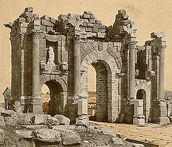
An inscription indicates that Bishop Marinus was probably the founder of the Christian basilica that was built in 324 AD. This is the oldest church to be found in Africa.
In 411 AD, a Donatist bishop of the city, named Severinus, was at the "Conference of Carthage", which brought together Catholic and Donatist bishops. At that moment, the city had no Catholic bishop. Isidore of Seville mentions a bishop of Castellum called Cerealis who was active in 431. A Voconius or Boconius who lived in about 460 AD is mentioned by Gennadius of Massilia as the author of polemical writings against Jews and Arians. Reparatus is known through his tomb inscription that shows he was bishop from 465 to his death in 475 AD. Petrus was one of the Catholic bishops whom the Vandal king Huneric summoned to Carthage in 484 AD and then exiled [3]
No longer a residential bishopric, Castellum Tingitii is today listed by the Catholic Church as a Titular see. [4]
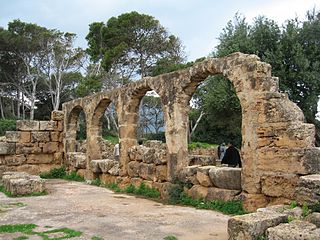
Under Emperor Constantine the Great in the 4th century, a Christian basilica [5] was built in 324 AD, just before the First Council of Nicaea. A century and a half later, in 475 AD, a counter-apse to the west was added to honour the tomb of Bishop Reparatus, whom an inscription states died in that year.

The floor was completely covered with mosaics. One mosaic inscription gives the dates 424 and 475 AD as the dates of construction and of the death of Reparatus. Two other funerary inscriptions in mosaic gives the dates 468 and 474 AD. [6]
The pavement contained a labyrinth design near the northwest entrance, [7] probably the earliest extant example of Christian use of this motif.
The labyrinth itself is much simpler than others found in Roman buildings in North Africa and elsewhere, such as the labyrinth at Susa, Tunis illustrated as figure 37 in W.H. Matthews's Mazes and Labyrinths. That in the Castellum Tingitanum church might be thought to be another pre-Christian one but for the inclusion in the centre of a set of letters that can be read from the centre in any direction except diagonally as "Sancta Ecclesia", making it possible to read this phrase in it more than 3,000 times. [8]
One writer interprets the combination of the diagram labyrinth with that of the letters in terms of polemics against the Donatist heresy; another as representing "the difficult progress (symbolized by the labyrinth), with all worldly 'ambages' awaiting to trap the wanderer, a progress leading towards the holy refuge of the Ecclesia and, eventually, towards the salvation of the soul". [9]
The basilica of St Reparatus, discovered in 1843, was allowed to be used as a public stable and has been completely destroyed. There was in it a beautiful mosaic of which, fortunately, drawings exist. From this it appears that the church was built in A.D. 324, and that St Reparatus, bishop of the diocese, was buried in it in 475. Orleansville occupies the site of the Roman Castellum Tingitanum. Dictionary of Arts in Encyclopedia Britannica [10]

Vandals conquered the city and partially destroyed it. Under Justinian I there was a limited recovery of the city, with improvement of the surviving Christian churches. Around 690 AD, Arabs reduced it to ruins, when they conquered all the actual Maghreb.
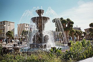
In the Middle Ages, the site was an area containing many statues and was known as Al-Asnam (Arabic for "old sculptures-ruins"): it was totally deserted. In 1843, French Maréchal Bugeaud founded among the ruins the new city of "Orléansville", [11] which was renamed "Al-Asnam" in 1962 and Chlef in 1980.
Some remains (statues, coins, etc..) of ancient Castellum Tingitii can be seen in the modern Museum of Chlef [12]
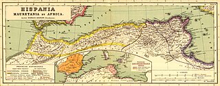
Mauretania is the Latin name for a region in the ancient Maghreb. It stretched from central present-day Algeria westwards to the Atlantic, covering northern Morocco, and southward to the Atlas Mountains. Its native inhabitants, seminomadic pastoralists of Berber ancestry, were known to the Romans as the Mauri and the Masaesyli.

Mauretania Caesariensis was a Roman province located in what is now Algeria in the Maghreb. The full name refers to its capital Caesarea Mauretaniae, in order to distinguish it from neighboring Mauretania Tingitana, which was ruled from Tingis.
Cherchell is a town on Algeria's Mediterranean coast, 89 kilometers (55 mi) west of Algiers. It is the seat of Cherchell District in Tipaza Province. Under the names Iol and Caesarea, it was formerly a Phoenician, Carthaginian, and Roman colony and the capital of the kingdoms of Numidia and Mauretania.

Zaraï was a Berber, Carthaginian, and Roman town at the site of present-day Aïn Oulmene, Algeria. Under the Romans, it formed part of the province of Numidia.

Theveste was a Roman colony situated in the present Tébessa, Algeria.
Tipasa, sometimes distinguished as Tipasa in Mauretania, was a colonia in the Roman province Mauretania Caesariensis, nowadays called Tipaza, and located in coastal central Algeria. Since 2002, it has been declared by UNESCO a "World Heritage Site".

Chlef is the capital of Chlef Province, Algeria. Located in the north of Algeria, 200 kilometres (120 mi) west of the capital, Algiers, it was founded in 1843, as Orléansville, on the ruins of Roman Castellum Tingitanum. In 1962, it was renamed al-Asnam, but since 1980 it has borne its present name, Chlef, which is derived from the name of the longest river in Algeria.

Zuccabar or Zucchabar was an ancient town in the Roman province of Mauretania Caesariensis. It is located in present-day Miliana, Algeria.

Tubunae was a Roman-Berber city in Algeria. It is believed to have been in either ancient Mauretania Caesariensis and/or Numidia.
Beniane is a town and commune in Mascara Province, Algeria at the site of ancient Ala Miliaria, a former bishopric which earns a Latin Catholic titular see.

Quiza, which Pliny the Elder called Quiza Xenitana, was a Roman–Berber colonia, located in the former province of Mauretania Caesariensis. The town is identified with ruins at Sidi Bellater, Algiers.

Cesarea in Mauretania was a Roman colony in Roman-Berber North Africa. It was the capital of Mauretania Caesariensis and is now called Cherchell, in modern Algeria.
Auzia was a Roman-Berber colonia in present-day Sour El-Ghozlane, Algeria. The area was located around 150 km south-east of Algiers, in the ancient province of Mauretania Caesariensis.
Rapidum was a Roman settlement and fort located in Mauretania Caesariensis, nearly 100 km south of Icosium (Algiers).

Cartennae or Cartenna was an ancient Berber, Carthaginian, and Roman port at present-day Ténès, Algeria. Under the Romans, it was part of the province of Mauretania Caesariensis.
The Diocese of Maxita is a bishopric in Algeria. It was a Roman Catholic Church diocese in the Roman province of Africa Proconsulare.
Vagal or Vagalitanus was a Vandal and Roman era civitas (town) in Mauretania Caesariensis, Roman North Africa. The town has been tentatively identified with Sidi ben Thiour on the Mekerra River near its confluence with the Sly River.(36.073819n, 1.094881e) Nearby towns included Castellum Tingitanum and Catabum Castra (Djidioua). The mines at Malakoff were to the north-east of the town.
Caesarea in Mauretania was an ancient city and bishopric in Roman North Africa. It was a Roman colonia in Roman-Berber North Africa. It was the capital of Mauretania Caesariensis and is now called Cherchell, in modern Algeria.
Tamada was an ancient Roman–Berber civitas in the province of Mauretania Caesariensis. The town lasted through the Byzantine Empire, Vandal Kingdom and Roman Empire into late antiquity, until at least the Muslim conquest of the Maghreb in the 7th century.

Castellum Dimmidi was a Roman castrum located in the south of the Mauretania Caesariensis