
Sevier County is a county of the U.S. state of Tennessee. As of the 2020 census, the population was 98,380. Its county seat and largest city is Sevierville. Sevier County comprises the Sevierville, TN Micropolitan Statistical Area, which is included in the Knoxville-Morristown-Sevierville, TN Combined Statistical Area.

Blount County is a county located in the East Tennessee Grand Division of the U.S. state of Tennessee. As of the 2020 census, its population was 135,280. The county seat is Maryville, which is also the county's largest city. Blount County is included in the Knoxville metropolitan area.

Catlettsburg is a home rule-class city in and the county seat of Boyd County, Kentucky, United States. The city population was 1,780 at the 2020 census. It is part of the Huntington–Ashland metropolitan area.
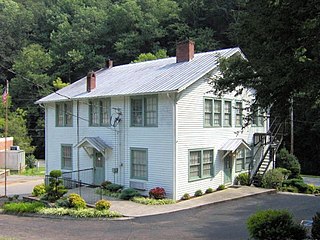
Pittman Center is a town in Sevier County, Tennessee, United States. The population was 454 at the 2020 census and 502 at the 2010 census. The town borders Gatlinburg and the Great Smoky Mountains National Park. U.S. 321 passes through the town.
Sevierville is a city in and the county seat of Sevier County, Tennessee, United States, located in eastern Tennessee. The population was 17,889 at the 2020 United States Census.

Seymour is a census-designated place (CDP) and unincorporated community in Blount and Sevier counties in the U.S. state of Tennessee. The CDP population was 14,705 at the 2020 U.S. census. It is included in the Knoxville, Tennessee Metropolitan Statistical Area.

John Sevier was an American soldier, frontiersman, and politician, and one of the founding fathers of the State of Tennessee. A member of the Democratic-Republican Party, he played a leading role in Tennessee's pre-statehood period, both militarily and politically, and he was elected the state's first governor in 1796. He served as a colonel of the Washington District Regiment in the Battle of Kings Mountain in 1780, and he commanded the frontier militia in dozens of battles against the Cherokee in the 1780s and 1790s.

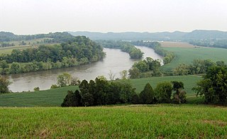
The Nolichucky River is a 115-mile (185 km) river that flows through western North Carolina and East Tennessee in the southeastern United States. Traversing the Pisgah National Forest and the Cherokee National Forest in the Blue Ridge Mountains, the river's watershed includes some of the highest mountains in the Appalachians, including Mount Mitchell in North Carolina, the highest point in the eastern United States. The river is a tributary of the French Broad River and is impounded by Nolichucky Dam near Greeneville, Tennessee.
Alder Branch is an unincorporated community in Sevier County, Tennessee, United States. It is accessible via State Route 338, outside of the city of Sevierville. The area is named for the Alder Branch Baptist Church founded in 1836, which itself is named for the Alder Branch stream which flows through the area.
Beech Springs is an unincorporated community in Sevier County, Tennessee, United States. Accessible by Tennessee Secondary Primary Route 139, it lies just south of Kodak.
Boyds Creek is an unincorporated community in Sevier County, Tennessee, United States. It is named for a small southward-flowing tributary of the French Broad River of the same name, which itself derives its name from a Virginian trader, killed by a band of Cherokee people, whose body was thrown into the stream. The creek was the site of a 1780 battle between white settlers and Cherokee angry at the settlers' encroachment onto their hunting territory.
Caton's Chapel is an unincorporated community in Sevier County, Tennessee, USA. It is accessible via State Route 454 and Catons Chapel Road, near State Route 416. Dolly Parton was raised and attended elementary school in Caton's Chapel. It is referred to by some natives as "The Chapel".
Cherokee Hills is an unincorporated community in Sevier County, Tennessee, United States. It is accessible via U.S. Route 411, near extreme eastern Sevierville.
Ray Lawrence Reagan was the Sevier County, Tennessee, county judge from 1958 until his death in 1978.

Strawberry Plains is an unincorporated community and census-designated place (CDP) in Jefferson, Knox, and Sevier counties in the State of Tennessee, United States. Before 2010, it was treated by the United States Census Bureau as a census county division. It is included in both the Knoxville Metropolitan Statistical Area and the Morristown Metropolitan Statistical Area.

Kodak is an unincorporated community and a neighborhood of Sevierville in Sevier County, Tennessee, United States. It is located along State Highway 139 and State Highway 66, and just south of I-40 and Knoxville, Tennessee. The elevation of Kodak is about 896 feet above sea level.
Garner is an unincorporated community in Boyd County, Kentucky, United States. Garner is located on Pigeon Roost Creek at the junction of Kentucky Route 854 and Kentucky Route 1945, 10.6 miles (17.1 km) southwest of Catlettsburg.
Shady Grove is an unincorporated community in Sevier County, Tennessee, United States. Shady Grove is located along Tennessee State Route 454 5.2 miles (8.4 km) east of Pigeon Forge.
Shady Grove is an unincorporated community in Jefferson County, Tennessee, United States.
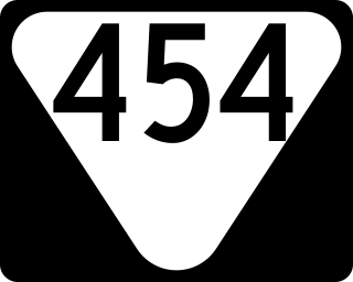
State Route 454 (SR 454) is a state highway in Sevier County, Tennessee. It serves as bypass of Sevierville and Pigeon Forge and a route to the Gatlinburg Arts and Crafts Community.


