
Sevier County is a county of the U.S. state of Tennessee. As of the 2020 census, the population was 98,380. Its county seat and largest city is Sevierville. Sevier County comprises the Sevierville, TN Micropolitan Statistical Area, which is included in the Knoxville-Morristown-Sevierville, TN Combined Statistical Area.

Blount County is a county located in the East Tennessee Grand Division of the U.S. state of Tennessee. As of the 2020 census, its population was 135,280. The county seat is Maryville, which is also the county's largest city. Blount County is included in the Knoxville, Tennessee metropolitan statistical area.
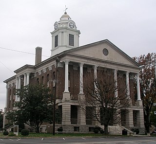
Bedford County is a county located in the U.S. state of Tennessee. As of the 2020 census, the population was 50,237. Its county seat is Shelbyville. Bedford County comprises the Shelbyville, TN Micropolitan Statistical Area, which is also included in the Nashville-Davidson-Murfreesboro, TN Combined Statistical Area.

Catonsville is a census-designated place (CDP) in Baltimore County, Maryland. The population was 41,567 at the 2010 census. The community lies to the west of Baltimore along the city's border. Catonsville contains the majority of the University of Maryland, Baltimore County (UMBC), a major public research university with close to 14,000 students.

Caton is a town in Steuben County, New York, United States. The population was 2,046 at the 2020 census. The town is named after Richard Caton.

Rutledge is a city in and the county seat of Grainger County, Tennessee. The city is part of both the Knoxville metropolitan area and the Morristown metropolitan area. As of the 2020 census, the city had a total population of 1,321.

Altamont is a town in Grundy County, Tennessee, United States. The population was 1,117 at the 2020 census. It is the county seat of Grundy County.
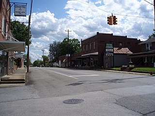
Chapel Hill is a town in northeastern Marshall County, Tennessee, United States. The town was named after Chapel Hill, North Carolina, by settlers from that area. The population was 1,717 as of the 2020 census.

Dixie Highway was a United States auto trail first planned in 1914 to connect the Midwest with the South. It was part of a system and was expanded from an earlier Miami to Montreal highway. The final system is better understood as a network of connected paved roads, rather than one single highway. It was constructed and expanded from 1915 to 1929.

U.S. Route 72 (US 72) is an east–west United States highway that travels for 317.811 miles (511.467 km) from southwestern Tennessee, throughout North Mississippi, North Alabama, and southeastern Tennessee. The highway's western terminus is in Memphis, Tennessee and its eastern terminus is in Chattanooga. It is the only U.S. Highway to begin and end in the same state, yet pass through other states in between. Prior to the U.S. Highway system signage being posted in 1926, the entire route was part of the Lee Highway.

U.S. Route 31W is the westernmost of two parallel routes for U.S. Route 31 from Nashville, Tennessee to Louisville, Kentucky.

New York State Route 225 (NY 225) is a state highway in the Southern Tier of New York in the United States. It is a 15.54-mile (25.01 km) loop route off NY 352 that connects the town of Big Flats and the city of Corning to the hamlet of Caton. The route begins in Big Flats and follows a generally east–west alignment across rural areas to Caton, where it turns to run in a north–south direction toward Corning. Development along the highway increases once it enters the Corning suburb of South Corning, and the rest of the route serves residential neighborhoods in South Corning and Corning. NY 225 is two lanes wide for its entire length; however, part of the highway in South Corning also has a center turn lane.
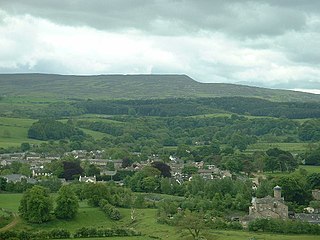
The civil parish of Caton-with-Littledale is situated in Lancashire, England, near the River Lune. The parish lies within the Forest of Bowland Area of Outstanding Natural Beauty and contains the villages of Caton, Brookhouse, Caton Green, Littledale and Townend.

An unsigned highway is a highway that has been assigned a route number, but does not bear road markings that would conventionally be used to identify the route with that number. Highways are left unsigned for a variety of reasons, and examples are found throughout the world. Depending on the policy of the agency that maintains the highway, and the reason for not signing the route, the route may instead be signed a different designation from its actual number, with small inventory markers for internal use, or with nothing at all.

Interstate 65 (I-65) meanders across 366 miles (589 km) of the Alabama countryside linking six of the state's 10 largest cities. The highway links together many important roadways that make commerce inside and outside of the state's boundaries possible. It starts at I-10 near Mobile. The route passes through the major cities of Montgomery, Birmingham, and Decatur before entering Tennessee in the north near the town of Ardmore, Alabama.

The State Route System of Tennessee is maintained and developed by the Tennessee Department of Transportation (TDOT) in the US state of Tennessee. Currently the state has 14,150 miles (22,770 km) of state-maintained roadways, including 1,233 miles (1,984 km) of Interstate Highways and 13,077 miles (21,045 km) of State Highways. All of the U.S. Routes in Tennessee have a state route routed concurrently with them, though the state route is hidden and only signed along the green mile marker signs that display mileage within each county. The state route system in Tennessee was established in 1923. Since the 1983 renumbering, state routes have been divided into primary and secondary routes with separate shields used for each.
Morrison City is an unincorporated community in Sullivan County, Tennessee, United States. Named for pioneer settler Peter Morison, Morrison City developed with the industrial growth of nearby Kingsport, Tennessee in the 1930s. Peter Morison, his wife Mary Kirkpatrick Morison, and other relatives, are buried in the Morrison Chapel Cemetery, in the heart of the community. They were awarded a land grant by the state of North Carolina, which controlled the area prior to Tennessee Statehood, in 1780. This was to recognize distinguished service during the Battle of King's Mountain.

U.S. Route 1 Alternate is an alternate route of US 1 in the U.S. state of Maryland. The highway runs 3.92 miles (6.31 km) between intersections with US 1 in Arbutus and in Baltimore. US 1 Alt. serves the southwestern Baltimore County community of Halethorpe and connects US 1 with full-access interchanges with Interstate 95 (I-95) and I-695. The Washington Boulevard portion of the alternate route was the original road southwest from Baltimore in the 18th century and was part of the turnpike southwest to Washington DC for much of the 19th century. The highway was paved in the early 1910s, expanded in the late 1910s and late 1920s, and became part of US 1 in 1926. The Caton Avenue portion of the alternate route was improved and expanded in the 1930s to serve as a rerouting of US 1 in southwest Baltimore. US 1 Alt. was created in 1949 when US 1 was moved to its present course through Arbutus and southwest Baltimore. The alternate route's interchanges with I-695 and I-95 were constructed in the late 1950s and mid-1970s, respectively.

Hardy's Chapel is an unincorporated community in Overton County, Tennessee, United States. It is concentrated around the intersection of Tennessee State Route 136, Poplar Springs Road, and Hardys Chapel Road in southern Overton County, between Cookeville and Hilham. It is home to a fire department, recycling center, convenience store, and several churches.


