In meteorology, a cloud is an aerosol consisting of a visible mass of minute liquid droplets, frozen crystals, or other particles suspended in the atmosphere of a planetary body or similar space. Water or various other chemicals may compose the droplets and crystals. On Earth, clouds are formed as a result of saturation of the air when it is cooled to its dew point, or when it gains sufficient moisture from an adjacent source to raise the dew point to the ambient temperature. They are seen in the Earth's homosphere, which includes the troposphere, stratosphere, and mesosphere. Nephology is the science of clouds, which is undertaken in the cloud physics branch of meteorology. There are two methods of naming clouds in their respective layers of the homosphere, Latin and common.

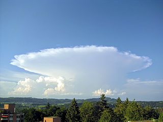
Cumulonimbus is a dense, towering vertical cloud, forming from water vapor carried by powerful upward air currents. If observed during a storm, these clouds may be referred to as thunderheads. Cumulonimbus can form alone, in clusters, or along cold front squall lines. These clouds are capable of producing lightning and other dangerous severe weather, such as tornadoes and hailstones. Cumulonimbus progress from overdeveloped cumulus congestus clouds and may further develop as part of a supercell. Cumulonimbus is abbreviated Cb.

Cumulus clouds are clouds which have flat bases and are often described as "puffy", "cotton-like" or "fluffy" in appearance. Their name derives from the Latin cumulo-, meaning heap or pile. Cumulus clouds are low-level clouds, generally less than 2,000 m (6,600 ft) in altitude unless they are the more vertical cumulus congestus form. Cumulus clouds may appear by themselves, in lines, or in clusters.

Altocumulus is a middle-altitude cloud genus that belongs mainly to the stratocumuliform physical category characterized by globular masses or rolls in layers or patches, the individual elements being larger and darker than those of cirrocumulus and smaller than those of stratocumulus. However, if the layers become tufted in appearance due to increased airmass instability, then the altocumulus clouds become more purely cumuliform in structure. Like other cumuliform and stratocumuliform clouds, altocumulus signifies convection. A sheet of partially conjoined altocumulus perlucidus is sometimes found preceding a weakening warm front, where the altostratus is starting to fragment, resulting in patches of altocumulus perlucidus between the areas of altostratus. Altocumulus is also commonly found between the warm and cold fronts in a depression, although this is often hidden by lower clouds.

Altostratus is a middle-altitude cloud genus belonging to the stratiform physical category characterized by a generally uniform gray to bluish-green sheet or layer. It is lighter in color than nimbostratus and darker than high cirrostratus. The sun can be seen through thin altostratus, but thicker layers can be quite translucent.

A stratocumulus cloud, occasionally called a cumulostratus, belongs to a genus-type of clouds characterized by large dark, rounded masses, usually in groups, lines, or waves, the individual elements being larger than those in altocumulus, and the whole being at a lower height, usually below 2,000 metres (6,600 ft). Weak convective currents create shallow cloud layers because of drier, stable air above preventing continued vertical development. Historically, in English, this type of cloud has been referred to as a twain cloud for being a combination of two types of clouds.

A nimbostratus cloud is a multi-level, amorphous, nearly uniform and often dark grey cloud that usually produces continuous rain, snow or sleet but no lightning or thunder.
Stratus clouds are low-level clouds characterized by horizontal layering with a uniform base, as opposed to convective or cumuliform clouds that are formed by rising thermals. More specifically, the term stratus is used to describe flat, hazy, featureless clouds at low altitudes varying in color from dark gray to nearly white. The word stratus comes from the Latin prefix strato-, meaning "layer". Stratus clouds may produce a light drizzle or a small amount of snow. These clouds are essentially above-ground fog formed either through the lifting of morning fog or through cold air moving at low altitudes over a region. Some call these clouds "high fog" for their fog-like form. While light rain may fall, this cloud does not indicate much meteorological precipitation.

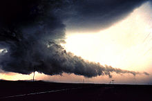
A wall cloud is a large, localized, persistent, and often abrupt lowering of cloud that develops beneath the surrounding base of a cumulonimbus cloud and from which tornadoes sometimes form. It is typically beneath the rain-free base (RFB) portion of a thunderstorm, and indicates the area of the strongest updraft within a storm. Rotating wall clouds are an indication of a mesocyclone in a thunderstorm; most strong tornadoes form from these. Many wall clouds do rotate; however, some do not.

A flammagenitus cloud, also known as a flammagenitus, pyrocumulus cloud, or fire cloud, is a dense cumuliform cloud associated with fire or volcanic eruptions. A flammagenitus is similar dynamically in some ways to a firestorm, and the two phenomena may occur in conjunction with each other. However, either may occur without the other.

A pileus, also called scarf cloud or cap cloud, is a small, horizontal, lenticular cloud appearing above a cumulus or cumulonimbus cloud. Pileus clouds are often short-lived, with the main cloud beneath them rising through convection to absorb them. They are formed by strong updraft at lower altitudes, acting upon moist air above, causing the air to cool to its dew point. As such, they are usually indicators of severe weather, and a pileus found atop a cumulus cloud often foreshadows transformation into a cumulonimbus cloud, as it indicates a strong updraft within the cloud.
A hot tower is a tropical cumulonimbus cloud that reaches out of the lowest layer of the atmosphere, the troposphere, and into the stratosphere. These formations are called "hot" because of the large amount of latent heat released as water vapor condenses into liquid and freezes into ice within the cloud. Hot towers in regions of sufficient vorticity may acquire rotating updrafts; these are known as vortical hot towers In some instances, hot towers appear to develop characteristics of a supercell, with deep and persistent rotation present in the updraft. The role of hot towers in tropical weather was first formulated by Joanne Simpson in 1958. Hot towers dominated discussions in tropical meteorology in the 1960s and are now considered the main drivers of rising air within tropical cyclones and a major component of the Hadley circulation. Although the prevalence of hot towers in scientific literature decreased in the 1970s, hot towers remain an active area of research. The presence of hot towers in tropical cyclones is correlated with an increase in the tropical cyclones's intensities.

Cumulonimbus calvus is a moderately tall cumulonimbus cloud that is capable of precipitation but has not yet reached the tropopause, which is the height of stratospheric stability at which cumulonimbus forms into cumulonimbus capillatus (fibrous-top) or cumulonimbus incus (anvil-top). Cumulonimbus calvus develops from cumulus congestus, and its further development, under auspicious conditions, will result in cumulonimbus incus.
An arcus cloud is a low, horizontal cloud formation, usually appearing as an accessory cloud to a cumulonimbus. Roll clouds and shelf clouds are the two main types of arcus clouds. They most frequently form along the leading edge or gust fronts of thunderstorms; some of the most dramatic arcus formations mark the gust fronts of derecho-producing convective systems. Roll clouds may also arise in the absence of thunderstorms, forming along the shallow cold air currents of some sea breeze boundaries and cold fronts.

The cumulonimbus flammagenitus cloud (CbFg), also known as the pyrocumulonimbus cloud, is a type of cumulonimbus cloud that forms above a source of heat, such as a wildfire or volcanic eruption, and may sometimes even extinguish the fire that formed it. It is the most extreme manifestation of a flammagenitus cloud. According to the American Meteorological Society’s Glossary of Meteorology, a flammagenitus is "a cumulus cloud formed by a rising thermal from a fire, or enhanced by buoyant plume emissions from an industrial combustion process."

Pannus, or scud clouds, is a type of fractus cloud at low height above ground, detached, and of irregular form, found beneath nimbostratus or cumulonimbus clouds. These clouds are often ragged or wispy in appearance. When caught in the outflow (downdraft) beneath a thunderstorm, scud clouds will often move faster than the storm clouds themselves. If the parent cloud that scud clouds pair with were to suddenly dissipate, the pannus cloud accessory would not be able to be told apart from a fractus cloud formation.

Cirrus spissatus or also called Cirrus densus and Cirrus nothus clouds are the highest of the main cloud genera, and may sometimes even occur in the lower stratosphere. The characteristic features of cirrus clouds are fine threads or wisps of ice crystals, generally white, but appearing grey when dense and seen against the light. There is no precipitation at the ground. It also frequently exhibits optical phenomena.
A cumulonimbus capillatus is a cumulonimbus cloud with dense cirrus clouds which makes the cloud's top appear to contain hair-like structures. The name comes from the Latin, capillatus, meaning "with hair".

Stratocumulus castellanus or Stratocumulus castellatus is a type of stratocumulus cloud, castellanus is derived from Latin, meaning 'of a castle' This type of cloud appears as cumuliform turrets vertically rising from a common horizontal cloud base, these turrets are taller than they are wide