Causey, New Mexico

Last updated

Causey, New Mexico
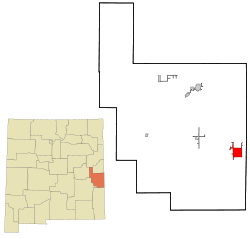
Roosevelt County New Mexico Incorporated and Unincorporated areas Causey Highlighted.svg
Location of Causey, New Mexico
Usa edcp location map.svg
Red pog.svg
Causey, New Mexico
Location in the United States
Coordinates: 33°51′01″N103°07′44″W / 33.85028°N 103.12889°W / 33.85028; -103.12889 [1]
Country United States
State New Mexico
County Roosevelt
Area
[2]
  Total3.75 sq mi (9.71 km2)
  Land3.75 sq mi (9.70 km2)
  Water0.00 sq mi (0.01 km2)
Elevation
[1]
4,026 ft (1,227 m)
Population
 (2020) [3]
  Total68
  Density18.16/sq mi (7.01/km2)
Time zone UTC-7 (Mountain (MST))
  Summer (DST) UTC-6 (MDT)
ZIP code
88113
Area code 575
FIPS code 35-12850
GNIS feature ID2413538 [1]

Causey is a village in eastern Roosevelt County, New Mexico, United States. The population was 104 at the 2010 census.

Contents

Geography

According to the United States Census Bureau, the village has a total area of 3.1 square miles (8.0 km2), all land.

Demographics

Historical population
CensusPop.Note
1960 38
1970 150294.7%
1980 81−46.0%
1990 57−29.6%
2000 52−8.8%
2010 104100.0%
2020 68−34.6%
U.S. Decennial Census [4] [3]

As of the census [5] of 2000, there were 52 people, 19 households, and 17 families residing in the village. The population density was 16.9 inhabitants per square mile (6.5/km2). There were 23 housing units at an average density of 7.5 per square mile (2.9/km2). The racial makeup of the village was 76.92% White, 9.62% Native American, 13.46% from other races. Hispanic or Latino of any race were 30.77% of the population.

There were 19 households, out of which 21.1% had children under the age of 18 living with them, 78.9% were married couples living together, 5.3% had a female householder with no husband present, and 10.5% were non-families. 10.5% of all households were made up of individuals, and 5.3% had someone living alone who was 65 years of age or older. The average household size was 2.74 and the average family size was 2.94.

In the village, the population was spread out, with 25.0% under the age of 18, 5.8% from 18 to 24, 19.2% from 25 to 44, 21.2% from 45 to 64, and 28.8% who were 65 years of age or older. The median age was 46 years. For every 100 females, there were 108.0 males. For every 100 females age 18 and over, there were 85.7 males.

The median income for a household in the village was $37,083, and the median income for a family was $37,083. Males had a median income of $21,250 versus $23,333 for females. The per capita income for the village was $19,663. None of the population and none of the families were below the poverty line.

Related Research Articles

<span class="mw-page-title-main">Campbell Hill, Illinois</span> Village in Illinois, United States

Campbell Hill is a village in Jackson County, Illinois, United States. The population was 309 at the 2020 census.

<span class="mw-page-title-main">San Jose, Illinois</span> Village in Illinois, United States

San Jose is a village in Logan and Mason counties, Illinois, United States, founded in 1858. The population was 479 at the 2020 census, down from 642 in 2010.

<span class="mw-page-title-main">Greensboro, Indiana</span> Town in Indiana, United States

Greensboro is a town in Greensboro Township, Henry County, Indiana, United States. The population was 143 at the 2010 census. The town was a 'station' on the Underground Railroad and was recognized for its active abolitionists.

The Forks is a plantation in Somerset County, Maine, United States. The population was 48 at the 2020 census.

<span class="mw-page-title-main">Wilton, Minnesota</span> City in Minnesota, United States

Wilton is a city in Beltrami County, Minnesota, United States. The population was 204 at the 2010 census. Wilton is considered a bedroom community of Bemidji.

Holt Township is a township in Fillmore County, Minnesota, United States. The population was 307 at the 2000 census.

Wildwood Township is a township in Itasca County, Minnesota, United States. The population was 193 at the 2010 census.

Hantho Township is a township in Lac qui Parle County, Minnesota, United States. The population was 154 at the 2000 census.

<span class="mw-page-title-main">River Bend, Missouri</span> Village in Missouri, United States

River Bend is a village in Jackson County, Missouri, United States. The population was 3 at the 2020 census. It is the only part of Jackson County that lies north of the Missouri River. In 1951, the Missouri River was relocated to a new channel, creating River Bend,. The county line still follows the original riverbed. It is part of the Kansas City metropolitan area. The mayor is Alex Dockler.

<span class="mw-page-title-main">Novelty, Missouri</span> Village in Missouri, United States

Novelty is a village in Knox County, Missouri, United States. As of the 2020 census, its population was 102.

<span class="mw-page-title-main">Cave, Missouri</span> City in Missouri, United States

Cave is a City in Lincoln County, Missouri, United States. The population was 5 at the 2010 census. However, As of the 2020 census, the population is 0, making it the smallest incorporated community in the U.S state of Missouri. It is the 939th largest city in Missouri and the 19481st largest city in the United States. Cave is currently declining at a rate of 0.00% annually and its population has decreased by 0.00% since the most recent census, which recorded a population of 5 in 2010.

<span class="mw-page-title-main">Bruno, Nebraska</span> Village in Nebraska, United States

Bruno is a village in Butler County, Nebraska, United States. The population was 99 at the 2010 census.

<span class="mw-page-title-main">McDonald, North Carolina</span> Town in North Carolina, United States

McDonald is a town in Robeson County, North Carolina, United States. The population was 113 at the 2010 census.

<span class="mw-page-title-main">Wheatland, North Dakota</span> Census-designated place in North Dakota, United States

Wheatland is a census-designated place (CDP) in Cass County, North Dakota, United States. The population was 68 at the 2010 census.

<span class="mw-page-title-main">Uniopolis, Ohio</span> Unincorporated community and Census-designated place in Ohio, United States

Uniopolis is an unincorporated community and former village in Auglaize County, Ohio, United States. The population was 188 at the 2020 census. It is included in the Wapakoneta, Ohio Micropolitan Statistical Area.

<span class="mw-page-title-main">Kirtland Hills, Ohio</span> Village in Ohio, United States

Kirtland Hills is a village in Lake County, Ohio, United States and a rural suburb of Cleveland. The population was 692 at the 2020 census.

<span class="mw-page-title-main">Limaville, Ohio</span> Census-designated place in Ohio, United States

Limaville is a census-designated place (CDP) and former village in Stark County, Ohio, United States. The population was 151 at the 2020 census. It is part of the Canton–Massillon Metropolitan Statistical Area.

<span class="mw-page-title-main">Glendale, Monroe County, Wisconsin</span> Town in Wisconsin, United States

Glendale is a town in Monroe County, Wisconsin, United States. The population was 579 at the 2000 census. The unincorporated community of Glendale is located in the town.

<span class="mw-page-title-main">McKinley, Polk County, Wisconsin</span> Town in Wisconsin, United States

The Town of McKinley is located in Polk County, Wisconsin, United States. The population was 328 at the 2000 census.

McCormack is an unorganized territory in Saint Louis County, Minnesota, United States, located near Hibbing and Balkan Township. The population was 237 at the 2000 census.

References

  1. 1 2 3 U.S. Geological Survey Geographic Names Information System: Causey, New Mexico
  2. "ArcGIS REST Services Directory". United States Census Bureau. Retrieved October 12, 2022.
  3. 1 2 "Census Population API". United States Census Bureau. Retrieved October 12, 2022.
  4. "Census of Population and Housing". Census.gov. Retrieved June 4, 2015.
  5. "U.S. Census website". United States Census Bureau . Retrieved January 31, 2008.