Cecil Township, Bottineau County, North Dakota

Last updated
Cecil Township
ND Bottineau County Cecil Township.svg
Location of Cecil Township
Coordinates: 48°40′32″N100°12′41″W / 48.67556°N 100.21139°W / 48.67556; -100.21139 Coordinates: 48°40′32″N100°12′41″W / 48.67556°N 100.21139°W / 48.67556; -100.21139 [1]
Country United States
State North Dakota
County Bottineau
Organized1910
Area
[2]
  Total35.35 sq mi (91.6 km2)
  Land35.19 sq mi (91.1 km2)
  Water0.16 sq mi (0.4 km2)
Elevation
[1]
1,535 ft (468 m)
Population
 (2000) [2]
  Total28
  Density0.8/sq mi (0.3/km2)
Time zone UTC-6 (Central (CST))
  Summer (DST) UTC-5 (CDT)
Area code 701
FIPS code 38-009-13060 [3]
GNIS feature ID 1759269 [4]

Cecil Township is a civil township in Bottineau County in the U.S. state of North Dakota. As of the 2000 census, its population was 28. [5]

Contents

Geography

Cecil Township is located in survey township 160N, Range 74W. [6]

Streams

History

Cecil Township was organized in 1910 from Lincoln School Township. [6]

The Soo Line Railroad was a major transportation route in the township. Overly, North Dakota in the eastern part of the township was a railroad hub, including a roundhouse for servicing locomotives. Overly also served as a way station for rail crews traveling east and west. [7]

In 1908 railroad officials established a second siding 5 miles (8.0 km) west of the city of Overly, and named the site Tasco ("clay earth"). It was reportedly named after the town of Tasco in Sheridan County, Kansas. Grain elevators were constructed and operated at the site, but the area saw little development. [8] Tasco is located at 48°41′14″N100°15′18″W / 48.68722°N 100.25500°W / 48.68722; -100.25500 (Tasco, North Dakota) . [9]

French settlers moved to Cecil Township around 1900 and established a small community about 4 miles (6.4 km) south of Overly that they named Little Fargo. The settlers originally moved to the area from Wild Rice, then a French settlement near Fargo. Settlers built a church they called the "Mission of St. Genevieve," which was moved to Overly in 1921. [10] Today, all that remains of Little Fargo is its cemetery, located at 48°38′39″N100°11′20″W / 48.6441°N 100.1890°W / 48.6441; -100.1890 (Little Fargo Cemetery) . [11]

Schools

Cities and populated places

Related Research Articles

Minden Township is a civil township of Sanilac County in the U.S. state of Michigan. The population was 633 at the 2000 census.

<span class="mw-page-title-main">Rugby, North Dakota</span> City in North Dakota, United States

Rugby is a city in, and the county seat of, Pierce County, North Dakota, United States. The population was 2,509 at the 2020 census, making it the 19th largest city in North Dakota. Rugby was founded in 1886.

<span class="mw-page-title-main">Fort Ransom, North Dakota</span> City in North Dakota, United States

Fort Ransom is a city in Ransom County, North Dakota, United States. The population was 91 at the 2020 census. Fort Ransom was founded in 1880 with the first merchants arriving in 1878.

Ada is a township in Dickey County, North Dakota, United States. Its population during the 2000 Census was 60, and was estimated at 52 in 2009. Its population in 1900 was 232.

Adler Township is one of the twenty-seven townships of Nelson County, North Dakota, United States. Its population during the 2000 Census was 47, and an estimated 38 as of 2009.

Advance Township is a township in Pembina County, North Dakota, United States. At the time of the 2000 Census, its population was 143, with an estimated 122 people as of 2009.

<span class="mw-page-title-main">Omemee, North Dakota</span> Place in North Dakota, United States

Omemee is a ghost town in Bottineau County in the U.S. state of North Dakota. It was a railroad hub in the early 1910s, located at the junction of two major railroads, the Soo Line Railroad and the Great Northern Railway. Incorporated as a city in 1902, Omemee has been abandoned since 2003.

<span class="mw-page-title-main">Nash, North Dakota</span> Census-designated place & Unincorporated community in North Dakota, United States

Nash is a census-designated place and unincorporated community in Walsh County, North Dakota, United States. Its population was 32 as of the 2010 census. The unincorporated community is located in Farmington Township, northwest of Grafton.

<span class="mw-page-title-main">Petrel, North Dakota</span> Ghost town in North Dakota, United States

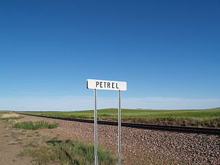
Petrel is a ghost town in Adams County, North Dakota, United States. It is located just across the border with South Dakota, between Lemmon, South Dakota, in Perkins County and Haynes. Petrel is a former railroad townsite and siding on the Milwaukee Road. The town was named for the long-winged pigeons seen in the area.

<span class="mw-page-title-main">Harlow, North Dakota</span> Unincorporated community in North Dakota, United States

Harlow is an unincorporated community in Benson County, North Dakota, United States. It is located in Butte Valley Township along North Dakota Highway 30. Harlow is assigned Zip code 58346, which it shares with neighboring Leeds.

<span class="mw-page-title-main">Roth, North Dakota</span> Unincorporated community in North Dakota, United States

Roth is an unincorporated community in Bottineau County in the U.S. state of North Dakota. It is located roughly 6 miles (9.7 km) to the west of Souris. Roth does not have a post office, but it shares the zip code of 58783 with Souris.

<span class="mw-page-title-main">Carbury, North Dakota</span> Unincorporated community in North Dakota, United States

Carbury is an unincorporated community in Bottineau County in the U.S. state of North Dakota. It is located along North Dakota Highway 14 in the eastern part of the county, east of Souris. The town is virtually abandoned, and the 2000 Census did not record a population. The post office closed in 1984, and it is now part of zip code 58783 covered by the post office in Souris.

<span class="mw-page-title-main">Pickering Township, Bottineau County, North Dakota</span> Township in North Dakota, United States

Pickering Township is a civil township in Bottineau County in the U.S. state of North Dakota. Its population was 193 as of the 2010 census, down from 213 at the 2000 census.

<span class="mw-page-title-main">Overly, North Dakota</span> City in North Dakota, United States

Overly is a city in Bottineau County in the U.S. state of North Dakota. The population was 10 at the 2020 census.

<span class="mw-page-title-main">Haram Township, Bottineau County, North Dakota</span> Township in North Dakota, United States

Haram Township is a civil township in Bottineau County in the U.S. state of North Dakota. As of the 2000 census, its population was 85.

Curlew Township is a former township in Morton County, North Dakota, United States. It was located near Glen Ullin, North Dakota.

Sherbrooke Township is a township in Steele County in the U.S. state of North Dakota. Its population as of the 2000 Census was 62, which had dropped to an estimated 46 people as of 2009. The township shares its name with Sherbrooke, North Dakota, which was the county seat from 1885 to 1919.

Brandenburg Township is a civil township located in Richland County, North Dakota, United States. Its population during the 2000 Census was 142, and estimated to be 126 as of 2009.

<span class="mw-page-title-main">Solon Township, Leelanau County, Michigan</span> Civil township in Michigan, United States

Solon Township is a civil township of Leelanau County in the U.S. state of Michigan. The population was 1,562 at the 2020 census.

<span class="mw-page-title-main">Columbus Township, Luce County, Michigan</span> Civil township in Michigan, United States

Columbus Township is a civil township of Luce County in the U.S. state of Michigan. As of the 2010 census, the township population was 204.

References

  1. 1 2 "Township of Cecil". Geographic Names Information System . United States Geological Survey, United States Department of the Interior.
  2. 1 2 U.S. Census Bureau. Census 2000, Summary File 1. "GCT-PH1. Population, Housing Units, Area, and Density: 2000 - County -- Subdivision and Place". American FactFinder. <http://factfinder2.census.gov>. Retrieved 2008-01-31.
  3. "U.S. Census website". United States Census Bureau . Retrieved 2008-01-31.
  4. "US Board on Geographic Names". United States Geological Survey. 2007-10-25. Retrieved 2008-01-31.
  5. U.S. Census Bureau. Census 2000. "Census Demographic Profiles, Cecil Township" (PDF). CenStats Databases. Retrieved 2009-01-31.[ dead link ]
  6. 1 2 U.S. Census Bureau (1913). "Number of Inhabitants, North Dakota" (PDF). Thirteenth Census of the United States: 1910. Government Printing Office. p. 324. Retrieved 2008-07-20.
  7. Brovald, Ken C. (1999). Silent Towns on the Prairie: North Dakota's Disappearing Towns and Farms. Missoula, Montana: Pictorial Histories Publishing Co. pp. 79–80. ISBN   1-57510-048-7. OCLC   41545361.
  8. Wick, Douglas A. (1988). North Dakota Place Names. Hedemarken Collectibles. p. 191. ISBN   0-9620968-0-6.
  9. "Tasco, North Dakota". Geographic Names Information System . United States Geological Survey, United States Department of the Interior.
  10. Sherman, William C. (1983). Pairie Mosaic: An Ethnic Atlas of Rural North Dakota. Fargo, North Dakota: North Dakota Institute for Regional Studies. p. 64. ISBN   0-911042-27-X. OCLC   256228966.
  11. "Little Fargo Cemetery". Geographic Names Information System . United States Geological Survey, United States Department of the Interior.