Westhope, North Dakota

Last updated

Westhope, North Dakota
ND Bottineau County Westhope.svg
Location of Westhope, North Dakota
Coordinates: 48°54′40″N101°01′04″W / 48.91111°N 101.01778°W / 48.91111; -101.01778
CountryUnited States
State North Dakota
County Bottineau
Founded1903
Government
   Mayor Russell Ballantyne
Area
[1]
  Total0.32 sq mi (0.84 km2)
  Land0.32 sq mi (0.84 km2)
  Water0.00 sq mi (0.00 km2)
Elevation
[2]
1,499 ft (457 m)
Population
 (2020) [3]
  Total374
  Estimate 
(2022) [4]
377
  Density1,157.89/sq mi (446.43/km2)
Time zone UTC-6 (Central (CST))
  Summer (DST) UTC-5 (CDT)
ZIP code
58793
Area code 701
FIPS code 38-85020
GNIS feature ID1036323 [2]
Website westhopend.com

Westhope is a city in Bottineau County, North Dakota, United States. The population was 374 at the 2020 census. [3] Westhope was founded in 1903 along a Great Northern Railway branch line that began in Rugby. The name was based on the slogan "Hope of the West," created by Great Northern officials to promote prosperity for the new town. [5]

Contents

Geography

According to the United States Census Bureau, the city has a total area of 0.33 square miles (0.85 km2), all land. [6]

Climate

Climate data for Westhope, North Dakota
MonthJanFebMarAprMayJunJulAugSepOctNovDecYear
Record high °F (°C)46
(8)
63
(17)
77
(25)
95
(35)
100
(38)
101
(38)
104
(40)
106
(41)
99
(37)
93
(34)
74
(23)
58
(14)
106
(41)
Average high °F (°C)17
(−8)
23
(−5)
35
(2)
57
(14)
69
(21)
77
(25)
82
(28)
82
(28)
71
(22)
55
(13)
35
(2)
20
(−7)
52
(11)
Average low °F (°C)−2
(−19)
4
(−16)
17
(−8)
30
(−1)
42
(6)
52
(11)
56
(13)
54
(12)
44
(7)
31
(−1)
17
(−8)
2
(−17)
29
(−2)
Record low °F (°C)−43
(−42)
−47
(−44)
−37
(−38)
−13
(−25)
13
(−11)
28
(−2)
33
(1)
29
(−2)
17
(−8)
−9
(−23)
−27
(−33)
−41
(−41)
−47
(−44)
Average precipitation inches (mm)0.52
(13)
0.46
(12)
0.84
(21)
1.09
(28)
2.35
(60)
3.42
(87)
2.88
(73)
2.01
(51)
1.39
(35)
1.29
(33)
0.67
(17)
0.53
(13)
17.45
(443)
Source: [7]

Demographics

Historical population
CensusPop.Note
1910 592
1920 439−25.8%
1930 52118.7%
1940 460−11.7%
1950 57525.0%
1960 82443.3%
1970 705−14.4%
1980 7415.1%
1990 578−22.0%
2000 533−7.8%
2010 429−19.5%
2020 374−12.8%
2022 (est.)377 [4] 0.8%
U.S. Decennial Census [8]
2020 Census [3]

2010 census

As of the census of 2010, there were 429 people, 190 households, and 117 families living in the city. The population density was 1,300.0 inhabitants per square mile (501.9/km2). There were 218 housing units at an average density of 660.6 per square mile (255.1/km2). The racial makeup of the city was 95.1% White, 1.2% Native American, 0.2% Asian, 0.2% Pacific Islander, and 3.3% from two or more races. Hispanic or Latino of any race were 0.5% of the population.

There were 190 households, of which 22.1% had children under the age of 18 living with them, 52.6% were married couples living together, 4.7% had a female householder with no husband present, 4.2% had a male householder with no wife present, and 38.4% were non-families. 35.3% of all households were made up of individuals, and 18.9% had someone living alone who was 65 years of age or older. The average household size was 2.15 and the average family size was 2.78.

The median age in the city was 49.5 years. 18.6% of residents were under the age of 18; 5.2% were between the ages of 18 and 24; 19.9% were from 25 to 44; 33.1% were from 45 to 64; and 23.3% were 65 years of age or older. The gender makeup of the city was 50.6% male and 49.4% female.

2000 census

As of the census of 2000, there were 533 people, 228 households, and 134 families living in the city. The population density was 1,663.5 inhabitants per square mile (642.3/km2). There were 268 housing units at an average density of 836.5 per square mile (323.0/km2). The racial makeup of the city was 98.31% White, 0.94% Native American, and 0.75% from two or more races.

There were 228 households, out of which 23.7% had children under the age of 18 living with them, 50.4% were married couples living together, 5.7% had a female householder with no husband present, and 41.2% were non-families. 40.4% of all households were made up of individuals, and 24.6% had someone living alone who was 65 years of age or older. The average household size was 2.14 and the average family size was 2.90.

In the city, the population was spread out, with 20.5% under the age of 18, 4.9% from 18 to 24, 19.5% from 25 to 44, 26.8% from 45 to 64, and 28.3% who were 65 years of age or older. The median age was 48 years. For every 100 females, there were 87.0 males. For every 100 females age 18 and over, there were 82.0 males.

The median income for a household in the city was $26,964, and the median income for a family was $30,938. Males had a median income of $24,554 versus $14,792 for females. The per capita income for the city was $18,252. About 10.1% of families and 8.7% of the population were below the poverty line, including 6.2% of those under age 18 and 18.2% of those age 65 or over.

Related Research Articles

<span class="mw-page-title-main">Lengby, Minnesota</span> City in Minnesota, United States

Lengby is a city in Polk County, Minnesota, United States. It is part of the Grand Forks ND-MN Metropolitan Statistical Area. The population was 92 at the 2020 census.

<span class="mw-page-title-main">Bottineau, North Dakota</span> City in North Dakota, United States

Bottineau is a city in Bottineau County, North Dakota, United States. It is the county seat of Bottineau County and is located just over ten miles (16 km) south of the Canada–United States border. The city's population was 2,194 at the 2020 census.

<span class="mw-page-title-main">Gardena, North Dakota</span> City in North Dakota, United States

Gardena is a city in Bottineau County, North Dakota, United States. The population was 24 at the 2020 census. Gardena was founded in 1905.

<span class="mw-page-title-main">Kramer, North Dakota</span> City in North Dakota, United States

Kramer is a city in Bottineau County, North Dakota, United States. The population was 24 at the 2020 census. Kramer was founded in 1905.

<span class="mw-page-title-main">Landa, North Dakota</span> City in North Dakota, United States

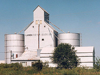
Landa is a city in Bottineau County, North Dakota, United States. The population was 41 at the 2020 census. Landa was founded in 1904.

<span class="mw-page-title-main">Maxbass, North Dakota</span> City in North Dakota, United States

Maxbass is a city in Bottineau County, North Dakota, United States. The population was 89 at the 2020 census. Maxbass was founded in 1905.

<span class="mw-page-title-main">Souris, North Dakota</span> City in North Dakota, United States

Souris is a rural small town in Bottineau County, North Dakota, United States. There is a large granary at Souris, also a bank, post office and bar; but no grocery or gas station. The population was 37 at the 2020 census. Souris was founded in 1901.

<span class="mw-page-title-main">Willow City, North Dakota</span> City in North Dakota, United States

Willow City is a city in Bottineau County, North Dakota, United States. The population was 149 at the 2020 census. Willow City was founded in 1887.

<span class="mw-page-title-main">Gilby, North Dakota</span> City in North Dakota, United States

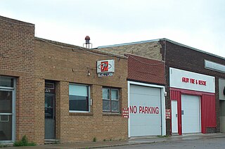
Gilby is a city in Grand Forks County, North Dakota, United States. It is part of the "Grand Forks, ND-MN Metropolitan Statistical Area" or "Greater Grand Forks". The population was 243 at the 2020 census. Gilby was founded in 1887.

<span class="mw-page-title-main">Carson, North Dakota</span> City in North Dakota, United States

Carson is a city in and the county seat of Grant County, North Dakota, United States. The population was 254 at the 2020 census.

<span class="mw-page-title-main">Mooreton, North Dakota</span> City in North Dakota, United States

Mooreton is a city in Richland County, North Dakota, United States. The population was 177 at the 2020 census. Mooreton was founded in 1884. It is part of the Wahpeton, ND–MN Micropolitan Statistical Area.

<span class="mw-page-title-main">Edinburg, North Dakota</span> City in North Dakota, United States

Edinburg is a city in Walsh County, North Dakota, United States. The population was 199 at the 2020 census.

<span class="mw-page-title-main">Ray, North Dakota</span> City in North Dakota, United States

Ray is a city in Williams County, North Dakota, United States. The population was 740 at the 2020 census.

<span class="mw-page-title-main">Claremont, South Dakota</span> Town in South Dakota, United States

Claremont is a town in Brown County, South Dakota, United States. The population was 108 at the 2020 census.

<span class="mw-page-title-main">Willow Lake, South Dakota</span> City in South Dakota, United States

Willow Lake is a city in Clark County, South Dakota, United States. The population was 255 at the 2020 census.

<span class="mw-page-title-main">Roscoe, South Dakota</span> City in South Dakota, United States

Roscoe is a city in central Edmunds County, South Dakota, United States. The population was 269 at the 2020 census.

<span class="mw-page-title-main">Tower City, North Dakota</span> City in North Dakota, United States

Tower City is a city in Barnes and Cass counties in the State of North Dakota. The population was 268 at the 2020 census.

<span class="mw-page-title-main">Sarles, North Dakota</span> City in North Dakota, United States

Sarles is a city in Cavalier and Towner counties in the State of North Dakota. The population was 16 at the 2020 census. Sarles was founded in 1905 at the end of the Great Northern railway extension north of Munich, called the "Sarles Branch". The town is named for North Dakota Governor Elmore Y. Sarles.

<span class="mw-page-title-main">Overly, North Dakota</span> City in North Dakota, United States

Overly is a city in Bottineau County in the U.S. state of North Dakota. The population was 10 at the 2020 census.

<span class="mw-page-title-main">Bentinck Township, Bottineau County, North Dakota</span> Township in North Dakota, United States

Bentinck Township is a township in Bottineau County in the U.S. state of North Dakota. Its population during the 2000 Census was 32, and an estimated 29 people as of 2009.

References

  1. "ArcGIS REST Services Directory". United States Census Bureau. Retrieved September 20, 2022.
  2. 1 2 U.S. Geological Survey Geographic Names Information System: Westhope, North Dakota
  3. 1 2 3 "Explore Census Data". United States Census Bureau . Retrieved October 17, 2023.
  4. 1 2 "City and Town Population Totals: 2020-2022". United States Census Bureau. October 17, 2023. Retrieved October 17, 2023.
  5. Wick, Douglas A. "Westhope (Bottineau County)". North Dakota Place Names. Retrieved May 5, 2011.
  6. "US Gazetteer files 2010". United States Census Bureau. Archived from the original on July 2, 2012. Retrieved June 14, 2012.
  7. "Westhope, ND Monthly Averages". The Weather Channel. Retrieved December 4, 2011.
  8. "U.S. Decennial Census". Census.gov. Retrieved June 1, 2013.