Bentinck Township, Bottineau County, North Dakota

Last updated

Bentinck Township
ND Bottineau County Bentinck Township.svg
Location of Bentinck Township
Coordinates: 48°53′00″N101°07′02″W / 48.88333°N 101.11722°W / 48.88333; -101.11722
Country United States
State North Dakota
County Bottineau
Organized1905
Area
[1]
  Total36.00 sq mi (93.2 km2)
  Land35.75 sq mi (92.6 km2)
  Water0.25 sq mi (0.6 km2)
Elevation
1,509 ft (460 m)
Population
 (2009) [2]
  Total29
  Density0.81/sq mi (0.31/km2)
Time zone UTC-6 (Central (CST))
  Summer (DST) UTC-5 (CDT)
Area code 701
FIPS code 38-06020 [3]
GNIS feature ID 1759266 [3]

Bentinck Township is a township in Bottineau County in the U.S. state of North Dakota. Its population during the 2000 Census was 32, [4] and an estimated 29 people as of 2009. [2]

Contents

History

Bentinck Township was organized in 1905. [5]

Geography

Bentinck Township is located in the western part of Bottineau County in survey township T162 North, Range 81 West. [6] According to the United States Census Bureau, the township has a total area of 36.00 square miles (93.2 km2), 99% of which is land. [1] The nearest cities are Westhope to the northeast and Maxbass to the south. [6]

Demographics

The 2000 Census reported there were 32 people, 12 households, and 11 families residing in the township. [4] The population density was 0.9 square miles (2.3 km2). There were 17 housing units at an average density of 0.5 square miles (1.3 km2). [1] The racial makeup of the township was 100% White. Norwegian was the largest ancestry group in the township, at 48.6%.

Of the 12 households in the township, only 16.7% had children under the age of 18 living with them. married couples made up 91.7% of the population. Just one household (8.3%) was a non-family household. The average household size was 2.67 people.

84% of the township was under the age of 65 at the 2000 Census, with children under the age of 18 making up 20% of the population. The largest group was 45- to 64-year-olds, with 40.6%, followed by 25- to 44-year-olds (18.8%) and those over 65 (15.6%). Just 3.1% of the population was made up of 18- to 24-year-olds. The median age was 48 years. [7]

The median household income for the township was $46,250, and the median family income was $52,500. Males had a median income of $56,250 versus $13,750 for females, with a per capita income of $16,938. [4]

Historical population
CensusPop.Note
1900 113
1910 19774.3%
1920 152−22.8%
1930 134−11.8%
1940 133−0.7%
1950 1437.5%
1960 74−48.3%
1970 62−16.2%
1980 8537.1%
1990 52−38.8%
2000 32−38.5%
2009 (est.)29

Related Research Articles

<span class="mw-page-title-main">Bottineau County, North Dakota</span> County in North Dakota, United States

Bottineau County is a county in the U.S. state of North Dakota. As of the 2020 census, the population was 6,379. Its county seat is Bottineau.

Martin Township is a civil township of Allegan County in the U.S. state of Michigan. The population was 2,629 at the 2010 census.

<span class="mw-page-title-main">Berrien Township, Michigan</span> Civil township in Michigan, United States

Berrien Township is a civil township of Berrien County in the U.S. state of Michigan. As of the 2010 census, the township population was 5,084.

<span class="mw-page-title-main">Leal, North Dakota</span> City in North Dakota, United States

Leal is a city in Barnes County in the state of North Dakota. The population was 27 at the 2020 census. Leal was founded in 1892. The name comes from the Scots word for "faithful," which in the phrase laund o the leal means Heaven.

<span class="mw-page-title-main">Fort Totten, North Dakota</span> CDP in North Dakota, United States

Fort Totten is a census-designated place (CDP) in Benson County, North Dakota, United States. The population was 1,243 at the 2010 census. Fort Totten is located within the Spirit Lake Reservation and is the site of tribal headquarters. The reservation has a total population estimated at 6,000. Although not formally incorporated as a city, Fort Totten has the largest population of any community in Benson County.

<span class="mw-page-title-main">Antler, North Dakota</span> City in North Dakota, United States

Antler is a city in Bottineau County in the U.S. state of North Dakota. The population was 22 at the 2020 census. Antler was founded in 1905.

<span class="mw-page-title-main">Bottineau, North Dakota</span> City in North Dakota, United States

Bottineau is a city in Bottineau County, North Dakota, United States. It is the county seat of Bottineau County and is located just over ten miles (16 km) south of the Canada–United States border. The city's population was 2,194 at the 2020 census.

<span class="mw-page-title-main">Landa, North Dakota</span> City in North Dakota, United States

Landa is a city in Bottineau County, North Dakota, United States. The population was 41 at the 2020 census. Landa was founded in 1904.

<span class="mw-page-title-main">Westhope, North Dakota</span> City in North Dakota, United States

Westhope is a city in Bottineau County, North Dakota, United States. The population was 374 at the 2020 census. Westhope was founded in 1903 along a Great Northern Railway branch line that began in Rugby. The name was based on the slogan "Hope of the West," created by Great Northern officials to promote prosperity for the new town.

<span class="mw-page-title-main">Kief, North Dakota</span> City in North Dakota, United States

Kief is a city in McHenry County, North Dakota, United States. The population was 8 at the 2020 census. It is part of the Minot Micropolitan Statistical Area. Kief was founded in 1908.

<span class="mw-page-title-main">Mission Hill, South Dakota</span> Town in South Dakota, United States

Mission Hill is a town in Yankton County, South Dakota, United States. The population was 190 at the 2020 census.

Mission Township is a civil township in Benson County, North Dakota, United States. As of the 2000 census, its population was 1,077. It is the most populous township in the county.

Alden Township is a rural township in Hand County, South Dakota, United States. The population was 33 at the 2000 census.

<span class="mw-page-title-main">Pickering Township, Bottineau County, North Dakota</span> Township in North Dakota, United States

Pickering Township is a civil township in Bottineau County in the U.S. state of North Dakota. Its population was 193 as of the 2010 census, down from 213 at the 2000 census.

<span class="mw-page-title-main">Overly, North Dakota</span> City in North Dakota, United States

Overly is a city in Bottineau County in the U.S. state of North Dakota. The population was 10 at the 2020 census.

Captain's Landing Township is a township in Morton County, North Dakota, United States. Its population as of the 2020 census was 115. It is located east of Mandan, North Dakota along the Missouri River, between Interstate 94 and the Bismarck Expressway.

Sherbrooke Township is a township in Steele County in the U.S. state of North Dakota. Its population as of the 2000 Census was 62, which had dropped to an estimated 46 people as of 2009. The township shares its name with Sherbrooke, North Dakota, which was the county seat from 1885 to 1919.

Finley Township is a township in Steele County in the U.S. state of North Dakota. Its population as of the 2000 Census was 64, which had dropped to an estimated 47 people as of 2009. The county seat of Finley, North Dakota is located in the township and shares its name.

<span class="mw-page-title-main">Blaine Township, Bottineau County, North Dakota</span> Township in North Dakota, United States

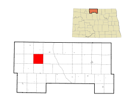
Blaine Township is a township in Bottineau County in the U.S. state of North Dakota. Its population during the 2000 Census was 30, and an estimated 27 people as of 2009.

Brandenburg Township is a civil township located in Richland County, North Dakota, United States. Its population during the 2000 Census was 142, and estimated to be 126 as of 2009.

References

  1. 1 2 3 U.S. Census Bureau. Census 2000, Summary File 1. "GCT-PH1. Population, Housing Units, Area, and Density: 2000 - County -- Subdivision and Place". American FactFinder. <http://factfinder2.census.gov>. Retrieved January 31, 2008.
  2. 1 2 U.S. Census Bureau (2010). "Incorporated Places and Minor Civil Divisions: North Dakota". 2009 Population Estimates. Archived from the original (CSV) on June 27, 2010. Retrieved June 22, 2010.
  3. 1 2 "US Board on Geographic Names". United States Geological Survey. October 25, 2007. Retrieved January 31, 2008.
  4. 1 2 3 U.S. Census Bureau. Census 2000. "Census Demographic Profiles, Bentinck Township" (PDF). CenStats Databases. Retrieved January 31, 2009.[ dead link ]
  5. U.S. Census Bureau (1913). "Number of Inhabitants, North Dakota" (PDF). Thirteenth Census of the United States: 1910. Government Printing Office . Retrieved July 20, 2008.
  6. 1 2 "Bentinck Township". Geographic Names Information System . United States Geological Survey, United States Department of the Interior.
  7. U.S. Census Bureau. Census 2000. "QT-P1. Age Groups and Sex, Bentinck Township". American FactFinder. <http://factfinder.census.gov>. Retrieved January 31, 2009.