Tasco, Kansas | |
|---|---|
 | |
 Tasco  Tasco | |
| Coordinates: 39°21′8″N100°18′10″W / 39.35222°N 100.30278°W [1] | |
| Country | United States |
| State | Kansas |
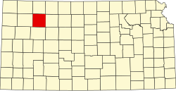
| County | Sheridan |
| Elevation | 2,500 ft (800 m) |
| Time zone | UTC-6 (CST) |
| • Summer (DST) | UTC-5 (CDT) |
| Area code | 785 |
| FIPS code | 20-70025 [1] |
| GNIS ID | 471276 [1] |
Tasco is an unincorporated community in Sheridan County, Kansas, United States. [1] It is located approximately seven miles east of Hoxie and south of U.S. Route 24, adjacent to an abandoned railroad.