Lucerne, Kansas

Last updated
Lucerne, Kansas
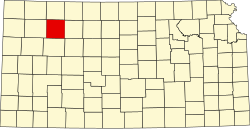
Map of Sheridan Co, Ks, USA.png
USA Kansas location map.svg
Red pog.svg
Lucerne
Usa edcp location map.svg
Red pog.svg
Lucerne
Coordinates: 39°29′48″N100°12′01″W / 39.49667°N 100.20028°W / 39.49667; -100.20028
Country United States
State Kansas
County Sheridan
Township Adell
Elevation
2,648 ft (807 m)
Population
  Total0
Time zone UTC-6 (CST)
  Summer (DST) UTC-5 (CDT)
Area code 785
GNIS ID 484550 [1]

Lucerne is a ghost town in Adell Township, Sheridan County, Kansas, United States. It is approximately 18 miles northeast of the county seat of Hoxie.

Contents

History

The town had a post office from 1880 until 1943. As of 2010, the remains of the town included a cemetery, stone foundation, and a partial wooden sign that used to announce the town's name. [2] As of the 2010 census, the entirety of Adell Township had a population of only 12. [3]

According to a 1912 reference work on Kansas, the town at that time held a population of 50, a general store, a hotel, a money order post office, and a daily stagecoach to the town of Jennings. [4]

Related Research Articles

<span class="mw-page-title-main">Thomas County, Kansas</span> County in Kansas, United States

Thomas County is a county located in the U.S. state of Kansas. Its county seat is Colby. As of the 2020 census, the county population was 7,930. The county was named after George Thomas, a general during the American Civil War.

<span class="mw-page-title-main">Sheridan County, Kansas</span> County in Kansas, United States

Sheridan County is a county located in the U.S. state of Kansas. Its county seat is Hoxie. As of the 2020 census, the county population was 2,447. The county was named in honor of Phillip Sheridan, a general during the American Civil War.

<span class="mw-page-title-main">Reno County, Kansas</span> County in Kansas, United States

Reno County is a county located in the U.S. state of Kansas. Its county seat and largest city is Hutchinson. As of the 2020 census, the population was 61,898. The county is named for Jesse Reno, a general during the American Civil War.

<span class="mw-page-title-main">Norton County, Kansas</span> County in Kansas, United States

Norton County is a county located in the U.S. state of Kansas. Its county seat and largest city is Norton. As of the 2020 census, the county population was 5,459. The county was established in 1867 and named for Orloff Norton, captain of Company L, 15th Kansas Militia Infantry Regiment.

<span class="mw-page-title-main">Logan County, Kansas</span> County in Kansas, United States

Logan County is a county located in the U.S. state of Kansas. Its county seat and largest city is Oakley. As of the 2020 census, the county population was 2,762. The county was named for John Logan, a general during the American Civil War. One of the county's distinctive features is a mile-long stretch of Smoky Hill Chalk bluffs that tower 100 feet (30 m) high over the Smoky Hill River and are dubbed "Little Jerusalem" for resemblance to the ancient walled city. The formation is mostly on private land. In 2016, The Nature Conservancy purchased the property and the Little Jerusalem Badlands State Park opened to the public in October 2019.

<span class="mw-page-title-main">Linn County, Kansas</span> County in Kansas, United States

Linn County is a county in the U.S. state of Kansas, located in along the eastern edge of Kansas, and is part of the Kansas City metropolitan area. Its county seat is Mound City, and its most populous city is Pleasanton. As of the 2020 census, the county population was 9,591. The county was named for Lewis Linn, a U.S. Senator from Missouri.

<span class="mw-page-title-main">Harper County, Kansas</span> County in Kansas, United States

Harper County is a county located in the U.S. state of Kansas. Its county seat and most populous city is Anthony. As of the 2020 census, the county population was 5,485. The county was named for Sergeant Marion Harper of the 2nd Kansas Cavalry, who died in battle during the American Civil War.

<span class="mw-page-title-main">Graham County, Kansas</span> County in Kansas, United States

Graham County is a county located in the U.S. state of Kansas. Its county seat and most populous city is Hill City. As of the 2020 census, the county population was 2,415. The county was named for John Graham, a captain in the American Civil War that died during the Battle of Chickamauga. The county is home to Nicodemus, founded 1877, which is the only remaining western town established by African Americans during the Reconstruction Period following the American Civil War.

<span class="mw-page-title-main">Gove County, Kansas</span> County in Kansas, United States

Gove County is a county in the U.S. state of Kansas. Its county seat is Gove City, and its most populous city is Quinter. As of the 2020 census, the county population was 2,718. The county was named for Granville Gove, a captain of Company G of the 11th Kansas Cavalry Regiment Volunteer Cavalry, who died from battle wounds during the American Civil War.

<span class="mw-page-title-main">Decatur County, Kansas</span> County in Kansas, United States

Decatur County is a county located in Northwest Kansas. Its county seat and most populous city is Oberlin. As of the 2020 census, the county population was 2,764. The county was named in honor of Stephen Decatur, Jr., a commodore in the United States Navy who served during both Barbary Wars in North Africa, the Quasi-War with France, and the War of 1812 with Britain.

<span class="mw-page-title-main">Sheridan Township, Clare County, Michigan</span> Civil township in Michigan, United States

Sheridan Township is a civil township of Clare County in the U.S. state of Michigan. The population was 1,548 at the 2020 census.

Adell Township is a township in Sheridan County, Kansas, United States. As of the 2010 Census, it had a population of 12.

<span class="mw-page-title-main">Sheridan Township, Crawford County, Kansas</span> Township in Kansas, United States

Sheridan Township is a township in Crawford County, Kansas, USA. As of the 2010 census, its population was 1,451.

<span class="mw-page-title-main">Cecil Township, Bottineau County, North Dakota</span> Township in North Dakota, United States

Cecil Township is a civil township in Bottineau County in the U.S. state of North Dakota. As of the 2000 census, its population was 28.

<span class="mw-page-title-main">Angelus, Kansas</span> Unincorporated community in Sheridan County, Kansas

Angelus is an unincorporated community in Sheridan County, Kansas, United States. It is located in Solomon Township, approximately 20 miles southwest of Hoxie. Also, it is located northwest of Grinnell and Interstate 70.

<span class="mw-page-title-main">Seguin, Kansas</span> Unincorporated community in Sheridan County, Kansas

Seguin is an unincorporated community in Sheridan County, Kansas, United States. It is located in Logan Township, approximately 10 miles west of Hoxie. It lies south of U.S. Route 24, to which it is linked by Kansas Highway 188.

<span class="mw-page-title-main">Studley, Kansas</span> Unincorporated community in Sheridan County, Kansas

Studley is an unincorporated community in Sheridan County, Kansas, United States, approximately 16 miles east of Hoxie along U.S. Route 24. It is on the eastern edge of the county in Valley Township, bordering Graham County. It was named after the Studley Royal Park, in England.

<span class="mw-page-title-main">Chicago, Kansas</span> Ghost town in Sheridan County, Kansas

Chicago is a ghost town in Adell Township, Sheridan County, Kansas, United States.

<span class="mw-page-title-main">Adell, Kansas</span> Ghost town in Sheridan County, Kansas

Adell is a ghost town in Sheridan County, Kansas, United States.

<span class="mw-page-title-main">Lund, Kansas</span> Ghost town in Decatur County, Kansas

Lund is a ghost town in Summit Township of Decatur County, Kansas, United States. It was located 12 miles south and 4 miles west of Oberlin.

References

  1. "Lucerne". Geographic Names Information System . United States Geological Survey, United States Department of the Interior.
  2. Bickel, Amy (October 2010). Chicago mirrored what killed towns, The Hutchinson News
  3. Adell Township, 2010 census information Archived 2020-02-14 at archive.today , American Fact Finder, retrieved 23 October 2017
  4. Kansas: A Cyclopedia of State History, p. 193 (1912)

Further reading