Studley, Kansas

Last updated
Studley, Kansas
Map of Sheridan Co, Ks, USA.png
USA Kansas location map.svg
Red pog.svg
Studley
Usa edcp location map.svg
Red pog.svg
Studley
Coordinates: 39°21′11″N100°09′49″W / 39.35306°N 100.16361°W / 39.35306; -100.16361 Coordinates: 39°21′11″N100°09′49″W / 39.35306°N 100.16361°W / 39.35306; -100.16361 [1]
Country United States
State Kansas
County Sheridan
Named for Studley Royal Park
Elevation
[1]
2,408 ft (734 m)
Time zone UTC-6 (CST)
  Summer (DST) UTC-5 (CDT)
Area code 785
FIPS code 20-68700 [1]
GNIS ID 471292 [1]

Studley is an unincorporated community in Sheridan County, Kansas, United States, [1] approximately 16 miles east of Hoxie along U.S. Route 24. It is on the eastern edge of the county in Valley Township, bordering Graham County. It was named after the Studley Royal Park, in England. [2]

Contents

History

The Lincoln-Colorado Railway (which became part of the Union Pacific Railroad) came through the area in 1888 and opened a station. A post office was opened in Studley in 1889, and remained in operation until it was discontinued in 1994. Prior to 1894, the post office there was called Skelton. [3]

Abraham Pratt, an immigrant from England, is usually credited as the founder of Studley, and he built his Cottonwood Ranch to the west of the hamlet. With Pratt's English roots, the community was named after Studley Royal Park in England. [4]

In 1910 it had a population of 75, but like many small western Kansas communities, its population has since declined, down to a population of 33 in the early 21st century. [5] [4] The community's grade school closed in the 1960s (part of the state unification plan), and its last grocery store closed in the 1970s. [4] The 99-mile Plainville-Colby branch of the Union Pacific Railroad which passed through Studley was abandoned in 1998. [6] [7]

Education

The community is served by Hoxie USD 412 public school district.

Related Research Articles

<span class="mw-page-title-main">Sheridan County, Kansas</span> County in Kansas, United States

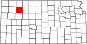
Sheridan County is a county located in the U.S. state of Kansas. As of the 2020 census, the county population was 2,447. Its county seat is Hoxie. The county was named in honor of Phillip H. Sheridan, a general of the American Civil War era.

<span class="mw-page-title-main">Marion County, Kansas</span> County in Kansas, United States

Marion County is a county located in the U.S. state of Kansas. Its county seat is Marion and its most populous city is Hillsboro. As of the 2020 census, the county population was 12,660. The county was named in honor of Francis Marion, a brigadier general of the American Revolutionary War, known as the "Swamp Fox".

<span class="mw-page-title-main">Marion, Kansas</span> City in Marion County, Kansas

Marion is a city in, and the county seat of, Marion County, Kansas, United States. It was named in honor of Francis Marion, a brigadier general of the American Revolutionary War, known as the "Swamp Fox". As of the 2020 census, the population of the city was 1,922.

<span class="mw-page-title-main">Palco, Kansas</span> City in Rooks County, Kansas

Palco is a city in Rooks County, Kansas, United States. As of the 2020 census, the population of the city was 208.

<span class="mw-page-title-main">Zurich, Kansas</span> City in Rooks County, Kansas

Zurich is a city in Rooks County, Kansas, United States. As of the 2020 census, the population of the city was 89.

<span class="mw-page-title-main">Hoxie, Kansas</span> City in Sheridan County, Kansas

Hoxie is a city in and the county seat of Sheridan County, Kansas, United States. As of the 2020 census, the population of the city was 1,211.

<span class="mw-page-title-main">Lund, Utah</span> Unincorporated community in the state of Utah, United States

Lund is an unincorporated village located in the Escalante Valley of northwestern Iron County, Utah, United States, approximately 35 miles (56 km) northwest of Cedar City. The town, established in the early twentieth century, was a station stop on the Los Angeles and Salt Lake Railroad, and was a community center for early twentieth century homesteaders. The area's population was never large, however, and most early settlers were unsuccessful due to the region's harsh and arid climate.

<span class="mw-page-title-main">Peck, Kansas</span> Unincorporated community in Sedgwick and Sumner Counties of Kansas

Peck is an unincorporated community on the Sedgwick and Sumner County border in Kansas, United States. As of the 2020 census, the population of the community and nearby areas was 162. It is located about 2 miles west of the Kansas Star Casino at Meridian Ave and 119th St S, next the Union Pacific Railroad.

<span class="mw-page-title-main">Codell, Kansas</span> Unincorporated community in Rooks County, Kansas

Codell is an unincorporated community in Rooks County, Kansas, United States. As of the 2020 census, the population of the community and nearby areas was 49.

<span class="mw-page-title-main">Cottonwood Ranch</span> United States historic place

The Cottonwood Ranch is an historic site near Studley in Valley Township, Sheridan County, Kansas, United States. The ranch is now preserved as a Kansas State Historic Site.

Robinette is a former unincorporated community in Baker County, Oregon, United States.

Cecil is an unincorporated community in Morrow County, Oregon, United States. It is about 14 miles (23 km) northwest of Ione, on Oregon Route 74. The Oregon Trail crossed Willow Creek here, and it was once an important stagecoach stop.

<span class="mw-page-title-main">Furley, Kansas</span> Unincorporated community in Sedgwick County, Kansas

Furley is an unincorporated community in Sedgwick County, Kansas, United States. As of the 2020 census, the population of the community and nearby areas was 39. It is located northwest of the intersection of Greenwich Road and 101st Street N, along the Union Pacific Railroad.

<span class="mw-page-title-main">Angelus, Kansas</span> Unincorporated community in Sheridan County, Kansas

Angelus is an unincorporated community in Sheridan County, Kansas, United States. It is located in Solomon Township, approximately 20 miles southwest of Hoxie. Also, it is located northwest of Grinnell and Interstate 70.

<span class="mw-page-title-main">Seguin, Kansas</span> Unincorporated community in Sheridan County, Kansas

Seguin is an unincorporated community in Sheridan County, Kansas, United States. It is located in Logan Township, approximately 10 miles west of Hoxie. It lies south of U.S. Route 24, to which it is linked by Kansas Highway 188.

<span class="mw-page-title-main">Plum Grove, Kansas</span> Ghost town in Kansas, United States

Plum Grove is a ghost town in Butler County, Kansas, United States. It was located in a rural area north of modern-day Potwin. No buildings remain at this former community site.

<span class="mw-page-title-main">Terra Cotta, Kansas</span> Ghost town in Kansas, United States

Terra Cotta is a ghost town in Ellsworth County, Kansas, United States.

Motor is a ghost town in Paradise Township, Rooks County, Kansas, United States.

Cresson is a ghost town in Northampton Township, Rooks County, Kansas, United States.

<span class="mw-page-title-main">Tasco, Kansas</span> Unincorporated community in Sheridan County, Kansas

Tasco is an unincorporated community in Sheridan County, Kansas, United States. It is located about 7 miles east of Hoxie and south of U.S. Route 24 highway, next to an abandoned railroad.

References

  1. 1 2 3 4 5 "Studley, Kansas", Geographic Names Information System , United States Geological Survey, United States Department of the Interior
  2. "Profile for Studley, Kansas". ePodunk . Retrieved 23 June 2014.
  3. "Kansas Post Offices, 1828-1961". Kansas Historical Society. Archived from the original on October 9, 2013. Retrieved 23 June 2014.{{cite web}}: CS1 maint: unfit URL (link)
  4. 1 2 3 "Origin of Town Names" (PDF). Solomon Valley Highway 24 Heritage Alliance. p. 6. Retrieved 9 April 2018.
  5. Kansas: A Cyclopedia of State History, p. 782 (1912) (encyclopedia entry on the "hamlet", misspelled as "Stidley")
  6. Surfact Transportation Board Decision, Docket No. AB-33, March 21, 1997, STB.gov, Retrieved 23 October 2017
  7. The Plainville Branch, Abandonedrails.com, Retrieved 23 October 2017

Further reading