Valley Township, Sheridan County, Kansas

Last updated

Valley Township
USA Kansas location map.svg
Red pog.svg
Valley Township
Coordinates: 39°21′00″N100°16′11″W / 39.35000°N 100.26972°W / 39.35000; -100.26972
Country United States
State Kansas
County Sheridan
Area
[1]
  Total71.78 sq mi (185.9 km2)
  Land71.72 sq mi (185.8 km2)
  Water0.06 sq mi (0.2 km2)  0.09%
Elevation
2,457 ft (749 m)
Population
 (2010)
  Total109
  Density1.5/sq mi (0.59/km2)
GNIS feature ID471220 [2]

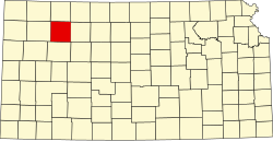
Valley Township is a township in Sheridan County, Kansas, United States. As of the 2010 Census, it had a population of 109. [3]

Related Research Articles

<span class="mw-page-title-main">Davie County, North Carolina</span> County in North Carolina, United States

Davie County is a county located in the U.S. state of North Carolina. As of the 2020 census, the population was 42,712. Its county seat is Mocksville.

<span class="mw-page-title-main">McLeod County, Minnesota</span> County in Minnesota, United States

McLeod County is a county in the U.S. state of Minnesota. At the 2020 census, the population was 36,771. Its county seat is Glencoe.

<span class="mw-page-title-main">Jackson County, Minnesota</span> County in Minnesota, United States

Jackson County is a county in the U.S. state of Minnesota. As of the 2020 census, the population was 9,989. Its county seat is Jackson.

<span class="mw-page-title-main">Guthrie County, Iowa</span> County in Iowa, United States

Guthrie County is a county located in the U.S. state of Iowa. As of the 2020 census, the population was 10,623. The county seat is Guthrie Center. The county was formed on January 15, 1851, and named after Captain Edwin B. Guthrie, who died in the Mexican–American War.

Cedar Valley Township is a township in Saint Louis County, Minnesota, United States. Cedar Valley Township was named for the white cedar in the valley of the Floodwood River. The population was 195 at the 2010 census.

Willow Valley Township is a township in Saint Louis County, Minnesota, United States. The population was 126 at the 2010 census.

<span class="mw-page-title-main">Penn Hills, Pennsylvania</span> Home rule township in Pennsylvania, United States

Penn Hills is a township with home rule status in Allegheny County, Pennsylvania, United States. The population was 41,059 as of the 2020 census. A suburb of Pittsburgh, Penn Hills is the second-largest municipality in Allegheny County.

<span class="mw-page-title-main">Honey Brook, Pennsylvania</span> Borough in Pennsylvania, United States

Honey Brook is a borough in Chester County, Pennsylvania, United States. The population of the borough was 1,895 at the 2020 census. The borough is surrounded by Honey Brook Township, and both are referred to locally collectively as Honey Brook.

<span class="mw-page-title-main">Schuylkill Township, Chester County, Pennsylvania</span> Township in Pennsylvania, United States

Schuylkill Township is a township in Chester County, Pennsylvania, United States. It contains the village of Valley Forge. The population was 8,516 at the 2010 census.

<span class="mw-page-title-main">Valley Township, Chester County, Pennsylvania</span> Township in Pennsylvania, United States

Valley Township is a township in Chester County, Pennsylvania, United States. The population was 6,794 at the 2010 census.

<span class="mw-page-title-main">Blooming Valley, Pennsylvania</span> Borough in Pennsylvania, United States

Blooming Valley is a borough in Crawford County, Pennsylvania, United States. The population was 344 at the 2020 census, up from 337 at the 2010 census.

<span class="mw-page-title-main">Wyoming, Pennsylvania</span> Borough in Luzerne County, Pennsylvania, US

Wyoming is a borough in the Greater Pittston area of Luzerne County, Pennsylvania, United States. It is located 5 miles (8 km) north of Wilkes-Barre, along the Susquehanna River. The population was 3,097 as of the 2020 census.

<span class="mw-page-title-main">Lower Frederick Township, Montgomery County, Pennsylvania</span> Township in Pennsylvania, United States

Lower Frederick Township is a township in Montgomery County, Pennsylvania, United States. The population was 4,840 at the 2010 census.

<span class="mw-page-title-main">Harrison Township, Allegheny County, Pennsylvania</span> Township in Pennsylvania, United States

Harrison Township is a township in Allegheny County in the U.S. state of Pennsylvania. The population was 10,169 at the 2020 census. Pennsylvania Route 28 passes through Harrison Township, connecting Kittanning to the northeast and Pittsburgh to the southwest. Allegheny Technologies has extensive steel mill facilities in Harrison Township, including its Allegheny Ludlum Brackenridge Works. Harrison Township is located at the far northeast corner of Allegheny County. Its northern border is the Butler County line and the Allegheny River forms the township's eastern boundary with Westmoreland County. Its northeast corner also touches Armstrong County.

<span class="mw-page-title-main">Scott Township, Allegheny County, Pennsylvania</span> CDP and Township in Pennsylvania, United States

Scott Township is a township in Allegheny County, Pennsylvania, United States. The population was 17,024 at the 2010 census.

<span class="mw-page-title-main">Devon, Pennsylvania</span> Census-designated place in Pennsylvania, United States

Devon is a census-designated place (CDP) located in Easttown township in Chester County, Pennsylvania, United States. The population was 1,515 at the 2010 census. The area is part of the Philadelphia Main Line suburbs.

<span class="mw-page-title-main">Gibraltar, Pennsylvania</span> Census-designated place in Pennsylvania, United States

Gibraltar is a census-designated place (CDP) in northern Robeson Township in southern Berks County, Pennsylvania, United States. Its population was 680 as of the 2010 census. The community is four miles from Birdsboro and 6.4 miles from downtown Reading. It is served by the Twin Valley School District and is across the Schuylkill River from Exeter.

<span class="mw-page-title-main">Dayton metropolitan area</span> Metropolitan area in Ohio, United States

The Dayton, OH Metropolitan Statistical Area, also known as Greater Dayton and the Miami Valley, as defined by the United States Census Bureau, is an area consisting of three counties in the Miami Valley region of Ohio and is anchored by the city of Dayton. As of 2020, it is the fourth largest metropolitan area in Ohio and the 73rd largest metropolitan area by population in the United States with a population of 814,049.

Plains is a census-designated place (CDP) in Plains Township, Luzerne County, Pennsylvania, United States. The population of the CDP was 4,335 at the 2010 census, out of 9,961 in the entire township.

Oval is a census-designated place (CDP) in Limestone Township, Lycoming County, Pennsylvania, United States. As of the 2010 census, it had a population of 361. Oval is not a separately incorporated community, but is a part of Limestone Township.

References

  1. "US Gazetteer files: 2010, 2000, and 1990". United States Census Bureau. February 12, 2011. Retrieved April 23, 2011.
  2. "Township of Valley". Geographic Names Information System . United States Geological Survey, United States Department of the Interior.
  3. "U.S. Census website". United States Census Bureau . Retrieved May 14, 2011.