Ute, Kansas

Last updated
Ute, Kansas
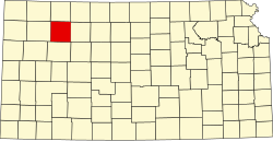
Map of Sheridan Co, Ks, USA.png
USA Kansas location map.svg
Red pog.svg
Ute
Usa edcp location map.svg
Red pog.svg
Ute
Coordinates: 39°25′25″N100°38′47″W / 39.42361°N 100.64639°W / 39.42361; -100.64639
Country United States
State Kansas
County Sheridan
Elevation
2,940 ft (900 m)
Population
  Total0
Time zone UTC-6 (CST)
  Summer (DST) UTC-5 (CDT)
Area code 785
GNIS ID 482589 [1]

Ute is a ghost town in Sheridan County, Kansas, United States.

Contents

History

Ute was issued a post office in 1886. The post office was discontinued in 1888. [2]

Related Research Articles

<span class="mw-page-title-main">Sheridan County, Kansas</span> County in Kansas, United States

Sheridan County is a county located in the U.S. state of Kansas. Its county seat is Hoxie. As of the 2020 census, the county population was 2,447. The county was named in honor of Phillip Sheridan, a general during the American Civil War.

<span class="mw-page-title-main">Sheridan Lake, Colorado</span> Town in Colorado, United States

Sheridan Lake is a Statutory Town located in Kiowa County, Colorado, United States. The population was 55 at the 2020 census.

<span class="mw-page-title-main">Towaoc, Colorado</span> Census-designated place in Montezuma County, Colorado, United States

Towaoc is a Census-designated place (CDP), a post office, and the capital of the Ute Mountain Ute Tribe located on the Ute Mountain Ute Reservation in Montezuma County, Colorado, United States. The Towaoc post office has the ZIP Code 81334. At the United States Census 2020, the population of the Towaoc CDP was 1,120.

<span class="mw-page-title-main">Philip Sheridan</span> United States Army general (1831–1888)

Philip Henry Sheridan was a career United States Army officer and a Union general in the American Civil War. His career was noted for his rapid rise to major general and his close association with General-in-chief Ulysses S. Grant, who transferred Sheridan from command of an infantry division in the Western Theater to lead the Cavalry Corps of the Army of the Potomac in the East. In 1864, he defeated Confederate forces under General Jubal Early in the Shenandoah Valley and his destruction of the economic infrastructure of the Valley, called "The Burning" by residents, was one of the first uses of scorched-earth tactics in the war. In 1865, his cavalry pursued Gen. Robert E. Lee and was instrumental in forcing his surrender at Appomattox Courthouse.

<span class="mw-page-title-main">Fort Leavenworth</span> Army installation in Kansas, United States

Fort Leavenworth is a United States Army installation located in Leavenworth County, Kansas, in the city of Leavenworth. Built in 1827, it is the second oldest active United States Army post west of Washington, D.C., and the oldest permanent settlement in Kansas. Fort Leavenworth has been historically known as the "Intellectual Center of the Army."

<span class="mw-page-title-main">Towner, Colorado</span> Census-designated place in Kiowa County, Colorado, United States

Towner is a census-designated place (CDP) in and governed by Kiowa County, Colorado, United States. The population of the Towner CDP was 18 at the United States Census 2020. The Sheridan Lake post office serves Towner postal addresses. Towner's post office closed down in 1992.

<span class="mw-page-title-main">Angelus, Kansas</span> Unincorporated community in Sheridan County, Kansas

Angelus is an unincorporated community in Sheridan County, Kansas, United States. It is located in Solomon Township, approximately 20 miles southwest of Hoxie. Also, it is located northwest of Grinnell and Interstate 70.

<span class="mw-page-title-main">Seguin, Kansas</span> Unincorporated community in Sheridan County, Kansas

Seguin is an unincorporated community in Sheridan County, Kansas, United States. It is located in Logan Township, approximately 10 miles west of Hoxie. It lies south of U.S. Route 24, to which it is linked by Kansas Highway 188.
<span class="mw-page-title-main">Studley, Kansas</span> Unincorporated community in Sheridan County, Kansas

Studley is an unincorporated community in Sheridan County, Kansas, United States, approximately 16 miles east of Hoxie along U.S. Route 24. It is on the eastern edge of the county in Valley Township, bordering Graham County. It was named after the Studley Royal Park, in England.

<span class="mw-page-title-main">Lucerne, Kansas</span> Ghost town in Sheridan County, Kansas

Lucerne is a ghost town in Adell Township, Sheridan County, Kansas, United States. It is approximately 18 miles northeast of the county seat of Hoxie.

<span class="mw-page-title-main">Chicago, Kansas</span> Ghost town in Sheridan County, Kansas

Chicago is a ghost town in Adell Township, Sheridan County, Kansas, United States.

<span class="mw-page-title-main">Stockrange, Kansas</span> Ghost town in Ellis County, Kansas

Stockrange is a ghost town in Lookout Township, Ellis County, Kansas, United States.

<span class="mw-page-title-main">Adell, Kansas</span> Ghost town in Sheridan County, Kansas

Adell is a ghost town in Sheridan County, Kansas, United States.

<span class="mw-page-title-main">Alcyone, Kansas</span> Ghost town in Sheridan County, Kansas

Alcyone is a ghost town in Sheridan County, Kansas, United States.

<span class="mw-page-title-main">Museum, Kansas</span> Ghost town in Sheridan County, Kansas

Museum is a ghost town in Sheridan County, Kansas, United States.

<span class="mw-page-title-main">Mystic, Kansas</span> Ghost town in Sheridan County, Kansas

Mystic is a ghost town in Sheridan County, Kansas, United States.

<span class="mw-page-title-main">Phelps, Kansas</span> Ghost town in Sheridan County, Kansas

Phelps is a ghost town in Sheridan County, Kansas, United States.

<span class="mw-page-title-main">Sheridan, Kansas</span> Ghost town in Sheridan County, Kansas

Sheridan is a ghost town in Sheridan County, Kansas, United States.

<span class="mw-page-title-main">Violenta, Kansas</span> Ghost town in Sheridan County, Kansas

Violenta is a ghost town in Sheridan County, Kansas, United States.

<span class="mw-page-title-main">Tasco, Kansas</span> Unincorporated community in Sheridan County, Kansas

Tasco is an unincorporated community in Sheridan County, Kansas, United States. It is located about 7 miles east of Hoxie and south of U.S. Route 24 highway, next to an abandoned railroad.

References

  1. "US Board on Geographic Names". United States Geological Survey. 1984-07-01. Retrieved 2017-12-30.
  2. "Kansas Post Offices, 1828-1961". Kansas Historical Society. Retrieved 2018-01-02.[ permanent dead link ]

Further reading