Plainville, Kansas | |
---|---|
Coordinates: 39°14′03″N99°18′03″W / 39.23417°N 99.30083°W [1] | |
Country | United States |
State | Kansas |
County | Rooks |
Founded | 1870s |
Incorporated | 1888 |
Named for | Plain |
Area | |
• Total | 1.20 sq mi (3.10 km2) |
• Land | 1.20 sq mi (3.10 km2) |
• Water | 0.00 sq mi (0.00 km2) |
Elevation | 2,149 ft (655 m) |
Population | |
• Total | 1,746 |
• Density | 1,500/sq mi (560/km2) |
Time zone | UTC-6 (CST) |
• Summer (DST) | UTC-5 (CDT) |
ZIP code | 67663 |
Area code | 785 |
FIPS code | 20-56150 |
GNIS ID | 2396222 [1] |
Website | plainvilleks.com |
Plainville is a city in Rooks County, Kansas, United States. [1] As of the 2020 census, the population of the city was 1,746. [3] It was named from its setting upon the plains. [4]
Washington Irving Griffin settled along a freight trail in an area known as Paradise Flats in 1877. In order to establish a post office, Griffin completed a US Postal Service application that required the signature of the local Justice of the Peace. While reviewing the application, Justice of the Peace Lambert P. Darland suggested the name "Plainville". Griffin operated the Plainville post office and a small store from his sod house, the first structure in what would become the city of Plainville. [5]
In 1888, Plainville filed for incorporation with 500 residents. Dan E. Miller was elected the first mayor. The first city council consisted of Dr. Volney M. Gray, Murray C. Knox, John Mullin, George Brooks and David E. Mickey. [6]
Union Pacific Railroad established an east–west route through Plainville in August 1888. The train tracks ran parallel to Mill Street, approximately one block to the north. The Train Depot was located on the northwest corner of N First Street and Meridian Street. A Roundhouse was located at N First Street and Madison Street. [7]
Plainville Mill & Elevator Co., (est. 1893) was a major employer and purchaser of locally grown wheat. The original mill was destroyed by fire in 1899 and soon replaced by a larger mill. The flour produced by the mill was of such fine quality, the company won a gold medal at the 1904 World's Fair. The mill was again destroyed by fire in 1950. Plainville Mill & Elevator Co. was located on N First Street between Madison and Meridian Streets. [5] [8]
In 1909, fire devastated the Plainville business district. The fire apparently started in a butcher shop on the south side of Mill Street in the early morning hours. Fire quickly spread to the north side of Mill Street. Seventeen structures were destroyed before the fire was contained. The burned out wooden buildings were replaced with stone and brick structures, many still standing on Mill Street today. [9]
Oil was discovered in Rooks County in 1927. The oil boom brought significant growth to Plainville in the 1940s and 1950s. The Bemis-Shutts oil field in the Saline River valley south of Plainville is one of the largest oil producers in the state of Kansas. [10] [11] [12]
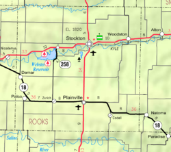
Plainville lies in the Smoky Hills region of the Great Plains on the north side of Paradise Creek, a tributary of the Saline River. Southwest of the city, the creek has been dammed to form a small reservoir, Plainville Township Lake. Plainville is approximately 9 miles (14 km) north of the Saline River and 13 miles (21 km) south of the South Fork Solomon River. Located in north-central Kansas at the intersection of U.S. Route 183 and K-18, Plainville is approximately 150 miles (240 km) northwest of Wichita and 253 miles (407 km) west of Kansas City. [13]
According to the United States Census Bureau, the city has a total area of 1.24 square miles (3.21 km2), all land. [14]
Plainville has a humid continental climate (Köppen Dfa) with hot, humid summers and cold, dry winters. The average yearly temperature in Plainville is 51.9 °F (11 °C), and, on average, the city receives 23.2 inches (589 mm) of precipitation a year. [15] Snowfall averages 23.3 inches (592 mm) per year. [16] On average, January is the coolest month, July is the warmest month, and May is the wettest month. The hottest temperature recorded in Plainville was 114 °F (46 °C) in 1940; the coldest temperature recorded was -29 °F (-34 °C) in 1989. [17]
Climate data for Plainville 4WNW, Kansas (1991–2020 normals, extremes 1904–present) | |||||||||||||
---|---|---|---|---|---|---|---|---|---|---|---|---|---|
Month | Jan | Feb | Mar | Apr | May | Jun | Jul | Aug | Sep | Oct | Nov | Dec | Year |
Record high °F (°C) | 83 (28) | 87 (31) | 94 (34) | 102 (39) | 103 (39) | 114 (46) | 116 (47) | 113 (45) | 112 (44) | 100 (38) | 88 (31) | 83 (28) | 116 (47) |
Mean daily maximum °F (°C) | 41.3 (5.2) | 45.0 (7.2) | 56.2 (13.4) | 65.4 (18.6) | 74.6 (23.7) | 85.9 (29.9) | 91.3 (32.9) | 88.9 (31.6) | 81.4 (27.4) | 68.5 (20.3) | 54.6 (12.6) | 42.6 (5.9) | 66.3 (19.1) |
Daily mean °F (°C) | 29.3 (−1.5) | 32.3 (0.2) | 42.3 (5.7) | 51.5 (10.8) | 61.8 (16.6) | 72.9 (22.7) | 78.2 (25.7) | 76.2 (24.6) | 68.0 (20.0) | 54.8 (12.7) | 41.6 (5.3) | 31.2 (−0.4) | 53.3 (11.8) |
Mean daily minimum °F (°C) | 17.3 (−8.2) | 19.6 (−6.9) | 28.5 (−1.9) | 37.6 (3.1) | 49.0 (9.4) | 59.9 (15.5) | 65.2 (18.4) | 63.5 (17.5) | 54.5 (12.5) | 41.1 (5.1) | 28.6 (−1.9) | 19.9 (−6.7) | 40.4 (4.7) |
Record low °F (°C) | −21 (−29) | −19 (−28) | −21 (−29) | 5 (−15) | 25 (−4) | 38 (3) | 45 (7) | 38 (3) | 26 (−3) | 6 (−14) | −8 (−22) | −29 (−34) | −29 (−34) |
Average precipitation inches (mm) | 0.64 (16) | 0.83 (21) | 1.40 (36) | 2.22 (56) | 4.10 (104) | 3.28 (83) | 3.95 (100) | 3.64 (92) | 2.24 (57) | 1.71 (43) | 1.15 (29) | 0.95 (24) | 26.11 (663) |
Average snowfall inches (cm) | 4.8 (12) | 5.4 (14) | 2.0 (5.1) | 1.2 (3.0) | 0.1 (0.25) | 0.0 (0.0) | 0.0 (0.0) | 0.0 (0.0) | 0.0 (0.0) | 0.6 (1.5) | 1.9 (4.8) | 3.7 (9.4) | 19.7 (50) |
Average precipitation days (≥ 0.01 in) | 3.2 | 3.7 | 5.1 | 7.1 | 9.3 | 8.6 | 7.9 | 7.8 | 5.5 | 5.3 | 4.1 | 3.7 | 71.3 |
Average snowy days (≥ 0.1 in) | 2.4 | 2.8 | 1.7 | 0.6 | 0.1 | 0.0 | 0.0 | 0.0 | 0.0 | 0.2 | 1.3 | 2.7 | 11.8 |
Source: NOAA [16] [18] |
Census | Pop. | Note | %± |
---|---|---|---|
1880 | 39 | — | |
1890 | 347 | 789.7% | |
1900 | 378 | 8.9% | |
1910 | 1,090 | 188.4% | |
1920 | 1,004 | −7.9% | |
1930 | 1,058 | 5.4% | |
1940 | 1,232 | 16.4% | |
1950 | 2,082 | 69.0% | |
1960 | 3,104 | 49.1% | |
1970 | 2,627 | −15.4% | |
1980 | 2,458 | −6.4% | |
1990 | 2,173 | −11.6% | |
2000 | 2,029 | −6.6% | |
2010 | 1,903 | −6.2% | |
2020 | 1,746 | −8.3% | |
U.S. Decennial Census |
The 2020 United States census counted 1,746 people, 784 households, and 475 families in Plainville. [19] [20] The population density was 1,459.9 per square mile (563.7/km2). There were 921 housing units at an average density of 770.1 per square mile (297.3/km2). [20] [21] The racial makeup was 95.42% (1,666) white or European American (94.33% non-Hispanic white), 0.34% (6) black or African-American, 0.29% (5) Native American or Alaska Native, 0.11% (2) Asian, 0.11% (2) Pacific Islander or Native Hawaiian, 0.34% (6) from other races, and 3.38% (59) from two or more races. [22] Hispanic or Latino of any race was 1.95% (34) of the population. [23]
Of the 784 households, 28.4% had children under the age of 18; 45.2% were married couples living together; 28.3% had a female householder with no spouse or partner present. 35.2% of households consisted of individuals and 19.8% had someone living alone who was 65 years of age or older. [20] The average household size was 2.3 and the average family size was 3.0. [24] The percent of those with a bachelor's degree or higher was estimated to be 17.2% of the population. [25]
24.1% of the population was under the age of 18, 6.7% from 18 to 24, 24.1% from 25 to 44, 24.6% from 45 to 64, and 20.4% who were 65 years of age or older. The median age was 39.9 years. For every 100 females, there were 105.2 males. [20] For every 100 females ages 18 and older, there were 107.7 males. [20]
The 2016-2020 5-year American Community Survey estimates show that the median household income was $52,946 (with a margin of error of +/- $7,568) and the median family income was $76,641 (+/- $16,219). [26] Males had a median income of $38,851 (+/- $7,051) versus $21,875 (+/- $5,148) for females. The median income for those above 16 years old was $27,214 (+/- $3,453). [27] Approximately, 1.5% of families and 4.4% of the population were below the poverty line, including 0.6% of those under the age of 18 and 15.9% of those ages 65 or over. [28] [29]
As of the census [30] of 2010, there were 1,903 people, 819 households, and 516 families residing in the city. The population density was 1,534.7 inhabitants per square mile (592.6/km2). There were 949 housing units at an average density of 765.3 per square mile (295.5/km2). The racial makeup of the city was 98.0% White, 0.2% African American, 0.3% Native American, 0.1% Asian, 0.1% Pacific Islander, 0.5% from other races, and 0.9% from two or more races. Hispanic or Latino of any race were 1.5% of the population.
There were 819 households, of which 29.8% had children under the age of 18 living with them, 49.9% were married couples living together, 8.9% had a female householder with no husband present, 4.2% had a male householder with no wife present, and 37.0% were non-families. 32.8% of all households were made up of individuals, and 16% had someone living alone who was 65 years of age or older. The average household size was 2.28 and the average family size was 2.91.
The median age in the city was 41.5 years. 24.7% of residents were under the age of 18; 6.8% were between the ages of 18 and 24; 22.1% were from 25 to 44; 26.2% were from 45 to 64; and 20.2% were 65 years of age or older. The gender makeup of the city was 47.9% male and 52.1% female.
As of the census of 2000, there were 2,029 people, 865 households, and 565 families residing in the city. The population density was 1,683.4 inhabitants per square mile (650.0/km2). There were 948 housing units at an average density of 786.5 per square mile (303.7/km2). The racial makeup of the city was 98.42% White, 0.39% African American, 0.39% Native American, 0.20% Asian, and 0.59% from two or more races. Hispanic or Latino of any race were 0.30% of the population.
There were 865 households, out of which 28.0% had children under the age of 18 living with them, 52.9% were married couples living together, 8.6% had a female householder with no husband present, and 34.6% were non-families. 31.3% of all households were made up of individuals, and 18.3% had someone living alone who was 65 years of age or older. The average household size was 2.30 and the average family size was 2.89.
In the city, the population was spread out, with 24.6% under the age of 18, 8.0% from 18 to 24, 23.7% from 25 to 44, 20.2% from 45 to 64, and 23.5% who were 65 years of age or older. The median age was 40 years. For every 100 females, there were 89.4 males. For every 100 females age 18 and over, there were 84.8 males.
As of 2000 the median income for a household in the city was $29,402, and the median income for a family was $35,673. Males had a median income of $29,408 versus $17,245 for females. The per capita income for the city was $15,134. About 7.7% of families and 8.6% of the population were below the poverty line, including 9.8% of those under age 18 and 3.4% of those age 65 or over. [31]
Max Malin Memorial Ballpark is a multi-field baseball complex.
Plainville City Park includes a playground, basketball court and swimming pool. [40]
Plainville Township Lake is located a half mile west of town. Fishing, picnics and other outdoor recreation are popular activities.
Rooks County Golf Course is a nine-hole, public course located 5 miles north of Plainville.
The community is served by Plainville USD 270 public school district. [41] The district has two schools.
Plainville High School Cardinals has won the following Kansas State High School championships:
Plainville Memorial Library is a public library serving the community since 1902. [46]
Plainville has one weekly newspaper, Plainville Times. [47] [48]
Radio station KFIX is licensed to Plainville, but broadcasts from Hays, Kansas playing a Classic rock format. [49] [50]
U.S. Route 183 runs north–south through Plainville, intersecting highway K-18 on the northern end of town.
Rooks County Regional Airport is located seven miles north of Plainville.
Rooks County Health Center is located on the north end of Plainville. [51]
Notable individuals who were born in and/or have lived in Plainville include:
Rooks County is a county located in the U.S. state of Kansas. Its county seat is Stockton, and its largest city is Plainville. As of the 2020 census, the county population was 4,919. The county was named for John Rooks, a private in Company I of the 11th Kansas Cavalry Regiment, who died at the Battle of Prairie Grove during the American Civil War.
Leon is a city in Butler County, Kansas, United States. As of the 2020 census, the population of the city was 669.
Lewis is a city in Edwards County, Kansas, United States. As of the 2020 census, the population of the city was 400. It is located along Highway 50.
Bucklin is a city in Ford County, Kansas, United States. As of the 2020 census, the population of the city was 727. It is located along U.S. Route 54 highway.
Grinnell is a city in Gove County, Kansas, United States. As of the 2020 census, the population of the city was 260.
Bogue is a city in Graham County, Kansas, United States. As of the 2020 census, the population of the city was 155. Bogue is located on K-18, south of U.S. Route 24, on the South Fork Solomon River.
Burrton is a city in Harvey County, Kansas, United States. It is named after Isaac T. Burr, former vice-president of the Atchison, Topeka and Santa Fe Railway. As of the 2020 census, the population of the city was 861.
Frankfort is a city in Marshall County, Kansas, United States. As of the 2020 census, the population of the city was 730.
Inman is a city in McPherson County, Kansas, United States. As of the 2020 census, the population of the city was 1,341.
Downs is a city in Osborne County, Kansas, United States. As of the 2020 census, the population of the city was 800.
Natoma is a city in Osborne County, Kansas, United States. As of the 2020 census, the population of the city was 302.
Bushton is a city in Rice County, Kansas, United States. As of the 2020 census, the population of the city was 203.
Little River is a city in Rice County, Kansas, United States. As of the 2020 census, the population of the city was 472.
Damar is a city in Rooks County, Kansas, United States. As of the 2020 census, the population of the city was 112.
Palco is a city in Rooks County, Kansas, United States. As of the 2020 census, the population of the city was 208.
Luray is a city in Russell County, Kansas, United States. As of the 2020 census, the population of the city was 166.
Oxford is a city in Sumner County, Kansas, United States. As of the 2020 census, the population of the city was 1,048.
Clifton is a city in Clay and Washington counties in the U.S. state of Kansas. As of the 2020 census, the population of the city was 454.
Oakley is a city in Gove, Logan, and Thomas counties in the U.S. state of Kansas. It is the county seat of Logan County. As of the 2020 census, the population of the city was 2,046.
Codell is an unincorporated community in Rooks County, Kansas, United States. As of the 2020 census, the population of the community and nearby areas was 49.