Igo, Kansas

Last updated
Igo, Kansas
USA Kansas location map.svg
Red pog.svg
Igo
Location within the state of Kansas
Usa edcp location map.svg
Red pog.svg
Igo
Igo (the United States)
Coordinates: 39°19′20″N99°08′56″W / 39.32222°N 99.14889°W / 39.32222; -99.14889
Country United States
State Kansas
County Rooks
Elevation
1,880 ft (570 m)
Population
  Total0
Time zone UTC-6 (CST)
  Summer (DST) UTC-5 (CDT)
Area code 785
GNIS ID 481907 [1]

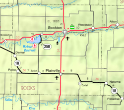
Igo is a ghost town in Medicine Township, Rooks County, Kansas, United States. [1]

History

Igo was located in Medicine Township along Big Medicine Creek. [2] A post office was issued to Igo in 1877. The post office was discontinued in 1904. [3] There is nothing left of Igo.

Related Research Articles

<span class="mw-page-title-main">Barber County, Kansas</span> County in Kansas, United States

Barber County is a county located in the south-central portion of the U.S. state of Kansas. Its county seat and most populous city is Medicine Lodge. As of the 2020 census, the county population was 4,228. The county was named for Thomas Barber, an abolitionist who was killed in Douglas County in 1855 during the Wakarusa War.

<span class="mw-page-title-main">Olive Township, Decatur County, Kansas</span> Township in Kansas, United States

Olive Township is a township in Decatur County, Kansas, United States. As of the 2000 census, its population was 68.

<span class="mw-page-title-main">Buckeye Township, Ellis County, Kansas</span> Township in Kansas, United States

Buckeye Township is a township in Ellis County, Kansas, United States. As of the 2010 census, its population was 414.

<span class="mw-page-title-main">Corinth, Kansas</span> Unincorporated community in Osborne County, Kansas

Corinth is an unincorporated community in Osborne County, Kansas, United States. It is located approximately 5.5 miles south of Downs.

McHale is a ghost town in Plainville Township, Rooks County, Kansas, United States.

Portage is a ghost town in Bow Creek Township, Rooks County, Kansas, United States.

Slate is a ghost town in Bow Creek Township, Rooks County, Kansas, United States.

Sugarloaf is a ghost town in Sugar Loaf Township, Rooks County, Kansas, United States.

Survey is a ghost town in Medicine Township, Rooks County, Kansas, United States.

Frankton is a ghost town in Medicine Township, Rooks County, Kansas, United States.

Highhill is a ghost town in Medicine Township, Rooks County, Kansas, United States.

Deliverance is a ghost town in Mt Ayr Township, Osborne County, Kansas, United States.

<span class="mw-page-title-main">Stockrange, Kansas</span> Ghost town in Ellis County, Kansas

Stockrange is a ghost town in Lookout Township, Ellis County, Kansas, United States.

<span class="mw-page-title-main">Walnut Grove, Kansas</span> Ghost town in Mitchell County, Kansas

Walnut Grove is a ghost town in Mitchell County, Kansas, United States.

Decatur is a ghost town in Roosevelt Township of Decatur County, Kansas, United States.

Hawkeye is a ghost town in Cook Township of Decatur County, Kansas, United States.

<span class="mw-page-title-main">Lund, Kansas</span> Ghost town in Decatur County, Kansas

Lund is a ghost town in Summit Township of Decatur County, Kansas, United States. It was located 12 miles south and 4 miles west of Oberlin.

Sheffield is a ghost town in Sappa Township of Decatur County, Kansas, United States.

Shibboleth is a former post village in Decatur County, Kansas, United States. Shibboleth Cemetery is located in the eastern part of the present-day Prairie Dog Township.

<span class="mw-page-title-main">Township 1, Rooks County, Kansas</span> Township in Kansas, United States

Township 1 is a township in Rooks County, Kansas, United States. Woodston is the largest population center in Township 1.

References

  1. 1 2 "Igo, Kansas", Geographic Names Information System , United States Geological Survey, United States Department of the Interior
  2. Blackmar, Frank Wilson (1912). Kansas: A Cyclopedia of State History, Volume 1, Chicago: Standard Publishing Company, p. 895
  3. "Kansas Post Offices, 1828-1961". Kansas Historical Society. Retrieved 2017-12-30.