Laton, Kansas

Last updated

Laton, Kansas
Map of Rooks Co, Ks, USA.png
USA Kansas location map.svg
Red pog.svg
Laton
Usa edcp location map.svg
Red pog.svg
Laton
Coordinates: 39°17′08″N99°04′36″W / 39.28556°N 99.07667°W / 39.28556; -99.07667
Country United States
State Kansas
County Rooks
Elevation
2,073 ft (632 m)
Population
  Total
0
Time zone UTC-6 (CST)
  Summer (DST) UTC-5 (CDT)
Area code 785
GNIS ID 484596 [1]

Laton is a ghost town in Corning Township, Rooks County, Kansas, United States. [1]

Contents

History

Eagle Creek was issued a post office in 1878. In 1884, the post office name was changed to Laton before being discontinued in 1904. [2] In addition to the post office Laton had a school, store, cream station, garage, blacksmith shop, and telephone office. [3] The population in 1910 was 30. [4]

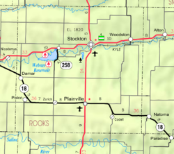
The Midland Trail (Red Line Highway) passed through Laton on its initial route in 1914. The creation of U.S Route 40N (US-24) to the north and K-18 highway to the south bypassed Laton. [5]

Laton School District R-5, Rooks County, Kansas was disorganized in 1962. [6] There is now nothing left of Laton.

References

  1. 1 2 "Laton, Kansas", Geographic Names Information System , United States Geological Survey, United States Department of the Interior
  2. "Kansas Post Offices, 1828-1961". Kansas Historical Society. Retrieved December 5, 2017.
  3. "Rooks County Historical Society", Plainville Times, 3 July 1975, p.4
  4. Blackmar, Frank Wilson (1912). Kansas: A Cyclopedia of State History, Volume 2, Chicago: Standard Publishing Company, p. 107
  5. "THE RED LINE", Plainville Times, 16 July 1914, p.1
  6. "TO WHOM IT MAY CONCERN", The Natoma Luray Independent, 19 July 1962, p.5

Further reading