Webster, Kansas

Last updated
Webster, Kansas
Webster - Kansas - Livery and Feed.jpg
Webster street scene (est. early 1900s)
Map of Rooks Co, Ks, USA.png
USA Kansas location map.svg
Red pog.svg
Webster
Usa edcp location map.svg
Red pog.svg
Webster
Coordinates: 39°24′06″N99°26′09″W / 39.40167°N 99.43583°W / 39.40167; -99.43583 [1]
Country United States
State Kansas
County Rooks
Township Belmont
Foundedlate 1870s
Platted 1885
Named for Daniel Webster
Elevation
[1]
1,870 ft (570 m)
Time zone UTC-6 (CST)
  Summer (DST) UTC-5 (CDT)
ZIP code
67669
Area code 785
FIPS code 20-76265
GNIS ID 484592 [1]

Webster was an unincorporated community in Belmont Township, Rooks County, Kansas, United States. [1]

Contents

History

The community of Webster was established in the Solomon Valley along the South Fork Solomon River in the late 1870s. Webster was created from two settlements; Webster settled on the north side of the river and Belmont that originated on the south side of the river.

Belmont was founded as a trading post in 1876. Due to flooding, the Belmont settlement was moved across the river adjoining the Webster settlement. Belmont was first to file an application for a post office. The Belmont application was denied as another Kansas town had previously been granted the name. Instead, Webster was granted a post office in 1879. [2]

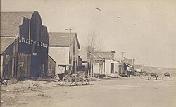
Webster, named for Daniel Webster, was surveyed, platted and filed in 1885. The town was never incorporated. [3]

In 1888, Webster had two doctors, two churches, a school and 24 businesses. A large city park called The Grove featured towering cottonwood trees. The population in 1910 was 200. [4]

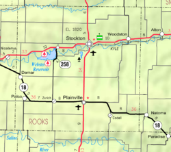
Construction of Webster Dam on the South Fork Solomon River was approved in 1953. Webster Reservoir would encompass the area occupied by the town of Webster. As a result, the town was relocated 2 miles to the southeast. Many businesses and residents chose not to relocate to the new town site. [5]

Geography

Webster lies approximately 0.5 miles (0.80 km) south-southeast of Webster Dam in the Smoky Hills region of the Great Plains. [6] [7] Webster is 0.3 miles (0.48 km) east of Kansas Highway 258, 2.5 miles (4.0 km) south of U.S. Route 24, and roughly 8 miles (13 km) west-southwest of Stockton, the county seat. [6]

The original site of Webster was located at 39°24′06″N99°26′09″W / 39.40167°N 99.43583°W / 39.40167; -99.43583 (39.4016756, -99.4359370), a location now submerged beneath Webster Reservoir. The site had an elevation of 1,893 feet (577 m). [1]

Education

Webster High School was closed in 1963. The grade school closed in 1969. [5] The Webster High School mascot was Webster Eagles.

Transportation

Webster lies at the intersection of two unpaved county roads: 11 Road, which runs north-south, and M Terrace, which runs east-west. [6]

Related Research Articles

<span class="mw-page-title-main">Stockton, Kansas</span> City in Rooks County, Kansas

Stockton is a city in and the county seat of Rooks County, Kansas, United States. As of the 2020 census, the population of the city was 1,480.

<span class="mw-page-title-main">Republican River</span> River in Colorado, United States

The Republican River is a river in the central Great Plains of North America, rising in the High Plains of eastern Colorado and flowing east 453 miles (729 km) through the U.S. states of Nebraska and Kansas.

<span class="mw-page-title-main">Smoky Hill River</span> River in the United States

The Smoky Hill River is a 575-mile (925 km) river in the central Great Plains of North America, running through Colorado and Kansas.

<span class="mw-page-title-main">Payette River</span> River in Idaho

The Payette River is an 82.7-mile-long (133.1 km) river in southwestern Idaho and is a major tributary of the Snake River.

<span class="mw-page-title-main">Mokelumne River</span> River in northern California

The Mokelumne River is a 95-mile (153 km)-long river in northern California in the United States. The river flows west from a rugged portion of the central Sierra Nevada into the Central Valley and ultimately the Sacramento–San Joaquin River Delta, where it empties into the San Joaquin River-Stockton Deepwater Shipping Channel. Together with its main tributary, the Cosumnes River, the Mokelumne drains 2,143 square miles (5,550 km2) in parts of five California counties. Measured to its farthest source at the head of the North Fork, the river stretches for 157 miles (253 km).

<span class="mw-page-title-main">K-99 (Kansas highway)</span>

K-99 is a state highway in the U.S. state of Kansas. The highway runs 234.473 miles (377.348 km) from Oklahoma State Highway 99 (SH-99) at the Oklahoma state line near Chautauqua north to Nebraska Highway 99 (N-99) at the Nebraska state line in Summerfield. K-99 connects Emporia with several smaller county seats to the south and north, including Sedan, Howard, Eureka, Alma, and Westmoreland while passing through the Flint Hills of eastern Kansas.

<span class="mw-page-title-main">Perry Lake (Kansas)</span> Reservoir in Jefferson County, Kansas

Perry Lake is a US Army Corps of Engineers operated reservoir in northeast Kansas. Its primary purposes are flood control, water reserve for nearby areas and regional recreation. The lake is approximately 11,150 acres (45 km²) in size, with over 160 miles (260 km) of shoreline. Perry Lake's full multi-purpose pool elevation is 891.5 feet (271.7 m) above sea level. Perry Lake is located about 40 miles (64 km) west of Kansas City, just northwest of Lawrence, Kansas. Its close proximity to Kansas City, Lawrence, and the state capitol, Topeka, make it a very popular destination, with the nickname "Paradise on the Plains".

<span class="mw-page-title-main">Solomon River</span> River in Kansas, United States

The Solomon River, often referred to as the "Solomon Fork", is a 184-mile-long (296 km) river in the central Great Plains of North America. The entire length of the river lies in the U.S. state of Kansas. It is a tributary of the Smoky Hill River.

<span class="mw-page-title-main">U.S. Route 59 in Oklahoma</span> Highway in Oklahoma

U.S. Highway 59 (US-59) heads along the eastern portion of the state of Oklahoma. US-59's 216.47-mile (348.37 km) route through Oklahoma takes it through the mountainous terrain of the eastern Oklahoma Ouachitas and Ozarks. US-59 serves several lakes and towns through Oklahoma's Green Country, including Grand Lake, a major recreation center. The route enters the state from Arkansas near Fogel, Arkansas, and ends at the Kansas state line south of Chetopa, Kansas.

<span class="mw-page-title-main">South Fork Solomon River</span> River in Kansas, United States

The South Fork Solomon River is a 292-mile-long (470 km) river in the central Great Plains of North America. The entire length of the river lies in the U.S. state of Kansas. It is a tributary of the Solomon River.

<span class="mw-page-title-main">Waconda Lake</span> Reservoir in Kansas, United States

Waconda Lake, also known as Glen Elder Reservoir, is a reservoir in Mitchell County and Osborne County, Kansas, United States. Built and managed by the U.S. Bureau of Reclamation for flood control and irrigation, it is also used for recreation. Glen Elder State Park is located on its north shore.

<span class="mw-page-title-main">North Fork Smoky Hill River</span> River in Kansas, United States

The North Fork Smoky Hill River is a river in the central Great Plains of North America. A tributary of the Smoky Hill River, it flows from eastern Colorado into western Kansas.

<span class="mw-page-title-main">Kirwin Reservoir</span> Reservoir in Phillips County, Kansas

Kirwin Reservoir is a reservoir in Phillips County, Kansas, United States. It is located next to the city of Kirwin in northern Kansas. The U.S. Bureau of Reclamation built it and continues to operate it for the purposes of flood control and area irrigation. The Kirwin National Wildlife Refuge lies on its shores.

<span class="mw-page-title-main">Webster Reservoir</span> Reservoir in Rooks County, Kansas

Webster Reservoir is a reservoir in Rooks County, Kansas, United States. Built and managed by the U.S. Bureau of Reclamation, it is used for flood control, irrigation, and recreation. Webster State Park is located on its shore.

<span class="mw-page-title-main">Cheney Reservoir</span> Reservoir in Sedgwick / Kingman /, Reno counties in Kansas

Cheney Reservoir is a reservoir on the North Fork Ninnescah River in Reno, Kingman, and Sedgwick counties of Kansas in the United States. Built and managed by the U.S. Bureau of Reclamation for local water supply, it is also used for flood control and recreation. Cheney State Park is located on its shore.

<span class="mw-page-title-main">North Fork Solomon River</span> River in Kansas, United States

The North Fork Solomon River is a river in the central Great Plains of North America. Its entire 287-mile (462 km) length lies within the U.S. state of Kansas. It is a tributary of the Solomon River.

<span class="mw-page-title-main">K-147 (Kansas highway)</span> State highway in Kansas

K-147 is an approximately 26-mile-long (42 km) north–south state highway in west-central Kansas. It runs from K-4 east of Brownell to Ogallah, just north of the junction with Interstate 70 (I-70) and U.S. Route 40 (US-40). K-147 serves Cedar Bluff State Park via locally maintained CC Road. The highway south of I-70 and US-40 is part of the Smoky Valley Scenic Byway. The highway travels through a mix of flat farmlands and rolling hills covered with grasslands. K-147 is a two-lane highway its entire length.

<span class="mw-page-title-main">Township 3, Rooks County, Kansas</span> Township in Kansas, United States

Township 3 is a township in Rooks County, Kansas, United States. Stockton is the largest population center in Township 3.

<span class="mw-page-title-main">Township 6, Rooks County, Kansas</span> Township in Kansas, United States

Township 6 is a township in Rooks County, Kansas, United States.

References

  1. 1 2 3 4 5 U.S. Geological Survey Geographic Names Information System: Webster, Kansas
  2. "Kansas Post Offices, 1828-1961". Kansas Historical Society. Retrieved 20 December 2016.
  3. "Origin of Town Names" (PDF). Solomon Valley Highway 24 Heritage Alliance. p. 5. Retrieved 9 April 2018.
  4. Blackmar, Frank Wilson (1912). Kansas: A Cyclopedia of State History, Volume 2, Chicago: Standard Publishing Company, p. 898
  5. 1 2 "History of Webster" (PDF). Solomon Valley Highway 24 Heritage Foundation. Retrieved 30 December 2016.
  6. 1 2 3 "General Highway Map - Rooks County, Kansas". Kansas Department of Transportation. January 2010. Retrieved 2015-11-19.
  7. "2003-2004 Official Transportation Map" (PDF). Kansas Department of Transportation. 2003. Retrieved 2015-11-19.

Further reading