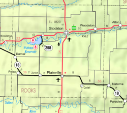
Adamson, Kansas

Last updated
Adamson, Kansas
USA Kansas location map.svg
Red pog.svg
Adamson
Usa edcp location map.svg
Red pog.svg
Adamson
Coordinates: 39°33′05″N99°35′06″W / 39.55139°N 99.58500°W / 39.55139; -99.58500
Country United States
State Kansas
County Rooks
Elevation
2,133 ft (650 m)
Population
  Total0
Time zone UTC-6 (CST)
  Summer (DST) UTC-5 (CDT)
Area code 785
GNIS ID 482521 [1]

Adamson is a ghost town in Bow Creek Township, Rooks County, Kansas, United States. [1]

History

Adamson was issued a post office in 1875. The post office was discontinued in 1892. There is nothing left of Adamson. [2]

Related Research Articles

<span class="mw-page-title-main">United States Post Office Department</span> Former US federal department (1872–1971)

The United States Post Office Department was the predecessor of the United States Postal Service, established in 1792. From 1872 to 1971, it was officially in the form of a Cabinet department. It was headed by the postmaster general.

<span class="mw-page-title-main">Harold Adamson</span> American lyricist

Harold Campbell Adamson was an American lyricist during the 1930s and 1940s.

<span class="mw-page-title-main">Frank Carlson</span> American politician

Frank Carlson was an American politician who served as the 30th governor of Kansas, Kansas State representative, United States representative, and United States senator from Kansas. Carlson is the only Kansan to have held all four offices. His political career spanned 40 years, beginning in November 1928 and ending in January 1969.

<span class="mw-page-title-main">William C. Adamson</span> American politician (1854–1929)

William Charles Adamson was a United States representative from Georgia, an Associate Justice of the United States Customs Court and a member of the Board of General Appraisers.

Adamson is classified as a Census designated place per the GNIS.

Whitmer is a census-designated place (CDP) in Randolph County, West Virginia, United States. It is 7.5 miles (12.1 km) south-southwest of Harman and is situated on the Dry Fork Cheat River. Whitmer had a post office, which closed on May 21, 2011. As of the 2010 census, its population was 106.

Sherman is an unincorporated community in Cherokee County, Kansas, United States.

Coalvale is an unincorporated community in Crawford County, Kansas, United States.

McHale is a ghost town in Plainville Township, Rooks County, Kansas, United States.

Portage is a ghost town in Bow Creek Township, Rooks County, Kansas, United States.

Sugarloaf is a ghost town in Sugar Loaf Township, Rooks County, Kansas, United States.

Highhill is a ghost town in Medicine Township, Rooks County, Kansas, United States.

<span class="mw-page-title-main">Bayne, Lincoln County, Kansas</span> Ghost town in Kansas, United States

Bayne is a ghost town in Lincoln County, Kansas, United States.

<span class="mw-page-title-main">Herman, Kansas</span> Ghost town in Kansas, United States

Herman is a ghost town in Lincoln County, Kansas, United States.

<span class="mw-page-title-main">Pleasant Valley, Lincoln County, Kansas</span> Ghost town in Kansas, United States

Pleasant Valley is a ghost town in Lincoln County, Kansas, United States.

Decatur is a ghost town in Roosevelt Township of Decatur County, Kansas, United States.

Shibboleth is a former post village in Decatur County, Kansas, United States. Shibboleth Cemetery is located in the eastern part of the present-day Prairie Dog Township.

References

  1. 1 2 "Adamson, Kansas", Geographic Names Information System , United States Geological Survey, United States Department of the Interior
  2. "Kansas Post Offices, 1828-1961". Kansas Historical Society. Retrieved 2017-12-30.