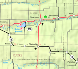
Motor, Kansas | |
---|---|
Coordinates: 39°11′37″N99°09′31″W / 39.19361°N 99.15861°W | |
Country | United States |
State | Kansas |
County | Rooks |
Elevation | 1,955 ft (596 m) |
Population | |
• Total | 0 |
Time zone | UTC-6 (CST) |
• Summer (DST) | UTC-5 (CDT) |
Area code | 785 |
GNIS ID | 482533 [1] |
Motor is a ghost town in Paradise Township, Rooks County, Kansas, United States. [1]
Motor was located three-quarters of a mile to the east of Codell. The town had two stores, a hotel and restaurant, a blacksmith shop, a wind driven grist mill and a saw mill. The Floreyville post office was moved to Motor and a school was established in 1879. The first school building was constructed of sod. A frame schoolhouse was built in 1886 and served the community until 1894.
In 1879, Motor failed to negotiate an agreement to establish a depot with Union Pacific Railroad. Union Pacific instead founded the community of Codell as a railroad town. Most of the frame buildings in Motor were moved to the growing community of Codell. [2] In 1889, the Motor post office was moved to Codell then Motor was soon abandoned. [3]
Elbing is a city in Butler County, Kansas, United States. It is named after the city Elbląg in northern Poland, formerly Prussia. As of the 2020 census, the population of the city was 226. It is located about 10.7 miles east of Interstate 135 in Newton, along the Union Pacific Railroad.
Whitewater is a city in Butler County, Kansas, United States. As of the 2020 census, the population of the city was 661.
Peabody is a city in Marion County, Kansas, United States. As of the 2020 census, the population of the city was 937. The city was named after F.H. Peabody of Boston, former vice-president of the Atchison, Topeka and Santa Fe Railway. Peabody is well known in the region for its Independence Day Celebration on July 4, and its historic 1880s downtown main street. It is located between Newton and Florence along U.S. Route 50 highway.
Turner is a neighborhood within Kansas City, Kansas, United States. It was formerly an unincorporated community of Wyandotte County, similar to Piper, Kansas. Turner has its own school district, Turner USD #202.
Annelly is a ghost town in Richland Township 9 miles southeast of Newton in Harvey County, Kansas, United States. The community was located along the Missouri Pacific Railroad line between Newton and Whitewater, but the track was abandoned in 2003. As of 2020, the land is privately owned farmland.
Geneva is an unincorporated community in Allen County, Kansas, United States.
Bayard is an unincorporated community in Allen County, Kansas, United States.
Codell is an unincorporated community in Rooks County, Kansas, United States. As of the 2020 census, the population of the community and nearby areas was 49.
Walker is an unincorporated community in Herzog Township, Ellis County, Kansas, United States. It is located between Hays and Russell, along old Hwy 40 on the north side of I-70. Walker has a post office with ZIP code 67674.
Irving is a ghost town in Marshall County, Kansas, United States, located six miles southeast of the city of Blue Rapids along the Big Blue River. Irving was one of the many towns affected by "Big Dam Foolishness" during the construction of Tuttle Creek Lake about ten miles to the south. Although the lake never reached the town, the federal government forced remaining residents to vacate the town.
Fairport is an unincorporated community in Paradise Township, Russell County, Kansas, United States. It is located about 12 miles north of Gorham near the west county line and next the Saline River.
Black Wolf is an unincorporated community in Ellsworth County, Kansas, United States. It is approximately 6 miles (9.7 km) west of Ellsworth.
Bayneville is an unincorporated community in Ohio Township, Sedgwick County, Kansas, United States. It is located on S 87th W between W 71st S and W 79st S.
Oursler is a ghost town in Marion County, Kansas, United States. It is currently a ghost town that was located approximately 3.5 miles southeast of Marion next to a former railroad. No buildings remain of this former community.
Yocemento is an unincorporated community in Big Creek Township, Ellis County, Kansas, United States. The settlement lies across the banks of Big Creek against the base of bluffs capped by massive limestone blocks, in which lies the 20th-century origin of the community.
Blaine is an unincorporated community in Pottawatomie County, Kansas, United States. It is located 29 miles northeast of Manhattan at the crossroads of K-99 and K-16.
Studley is an unincorporated community in Sheridan County, Kansas, United States, approximately 16 miles east of Hoxie along U.S. Route 24. It is on the eastern edge of the county in Valley Township, bordering Graham County. It was named after the Studley Royal Park, in England.
Plum Grove is a ghost town in Butler County, Kansas, United States. It was located in a rural area north of modern-day Potwin. No buildings remain at this former community site.
Cresson is a ghost town in Northampton Township, Rooks County, Kansas, United States.
Township 12 is a township in Rooks County, Kansas, United States. Codell is the largest population center in Township 12.