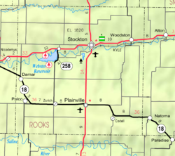
Cresson, Kansas

Last updated
Cresson, Kansas
USA Kansas location map.svg
Red pog.svg
Cresson
Location within the state of Kansas
Usa edcp location map.svg
Red pog.svg
Cresson
Cresson (the United States)
Coordinates: 39°16′40″N99°35′07″W / 39.27778°N 99.58528°W / 39.27778; -99.58528 Coordinates: 39°16′40″N99°35′07″W / 39.27778°N 99.58528°W / 39.27778; -99.58528
Country United States
State Kansas
County Rooks
Elevation
2,234 ft (681 m)
Population
  Total0
Time zone UTC-6 (CST)
  Summer (DST) UTC-5 (CDT)
Area code 785
GNIS ID 482530 [1]

Cresson is a ghost town in Northampton Township, Rooks County, Kansas, United States. [1]

History

Cresson, Kansas (named for Cresson, PA) was granted a post office in 1879. [2] In 1887, rumors circulated that Union Pacific Railroad would lay track 1+12 miles to the south of Cresson. Many citizens and businesses abandoned Cresson to form the community of New Cresson along the expected railroad route. In 1888, Union Pacific established the railroad near the original location of Cresson, then created Palco as a depot. Nothing is left of Cresson or New Cresson. [3]

Related Research Articles

Rooks County, Kansas County in Kansas, United States

Rooks County is a county located in the U.S. state of Kansas. As of the 2020 census, the county population was 4,919. The county seat is Stockton, and the largest city is Plainville. The county was named for Private John C. Rooks of the 11th Kansas Infantry who died at the Battle of Prairie Grove near Fayetteville, Arkansas, during the Civil War.

Elbing, Kansas City in Butler County, Kansas

Elbing is a city in Butler County, Kansas, United States. It is named after the city Elbląg in northern Poland, formerly Prussia. As of the 2020 census, the population of the city was 226. It is located about 10.7 miles east of Interstate 135 in Newton, along the Union Pacific Railroad.

Whitewater, Kansas City in Butler County, Kansas

Whitewater is a city in Butler County, Kansas, United States. As of the 2020 census, the population of the city was 661.

Ramona, Kansas City in Marion County, Kansas

Ramona is a city in Marion County, Kansas, United States. As of the 2020 census, the population of the city was 78. It is located southwest of Herington next to a railroad.

Damar, Kansas City in Rooks County, Kansas

Damar is a city in Rooks County, Kansas, United States. As of the 2010 census, the city population was 132.

Palco, Kansas City in Rooks County, Kansas

Palco is a city in Rooks County, Kansas, United States. As of the 2010 census, the city population was 277.

Zurich, Kansas City in Rooks County, Kansas

Zurich is a city in Rooks County, Kansas, United States. As of the 2010 census, the city population was 99.

Alta Vista, Kansas City in Wabaunsee County, Kansas

Alta Vista is a city in Wabaunsee County, Kansas, United States. As of the 2010 census, the city population was 444.

Union Pacific Railroad Class I freight railroad in the United States

The Union Pacific Railroad, legally Union Pacific Railroad Company and simply Union Pacific, is a freight-hauling railroad that operates 8,300 locomotives over 32,200 miles (51,800 km) routes in 23 U.S. states west of Chicago and New Orleans. Union Pacific is the second largest railroad in the United States after BNSF. Union Pacific and BNSF have a duopoly on transcontinental freight rail lines in the Western, Midwestern and Southern United States.

Missouri–Kansas–Texas Railroad

The Missouri–Kansas–Texas Railway is a former Class I railroad company in the United States, with its last headquarters in Dallas, Texas. Established in 1865 under the name Union Pacific Railway, Southern Branch, it came to serve an extensive rail network in Texas, Oklahoma, Kansas, and Missouri. In 1988, it merged with the Missouri Pacific Railroad; today, it is part of Union Pacific Railroad.

Missouri Pacific Railroad Defunct American Class I railroad

The Missouri Pacific Railroad, commonly abbreviated as MoPac, was one of the first railroads in the United States west of the Mississippi River. MoPac was a Class I railroad growing from dozens of predecessors and mergers. In 1967, the railroad operated 9,041 miles of road and 13,318 miles of track, not including DK&S, NO&LC, T&P, and its subsidiaries C&EI and Missouri-Illinois.

The Kansas Pacific Railway (KP) was a historic railroad company that operated in the western United States in the late 19th century. It was a federally chartered railroad, backed with government land grants. At a time when the first transcontinental railroad was being constructed by the Central Pacific and the Union Pacific, it tried and failed to join the transcontinental ranks. It was originally the "Union Pacific, Eastern Division", although it was completely independent. The Pennsylvania Railroad, working with Missouri financiers, designed it as a feeder line to the transcontinental system. The owners lobbied heavily in Washington for money to build a railroad from Kansas City to Colorado, and then to California. It failed to get funding to go west of Colorado. It operated many of the first long-distance lines in the state of Kansas in the 1870s, extending the national railway network westward across that state and into Colorado. Its main line furnished a principal transportation route that opened up settlement of the central Great Plains, and its link from Kansas City to Denver provided the last link in the coast-to-coast railway network in 1870. The railroad was consolidated with the Union Pacific in 1880, and its mainline continues to be an integral part of the Union Pacific network today.

Corbin, Kansas Unincorporated community in Sumner County, Kansas

Corbin is an unincorporated community in Sumner County, Kansas, United States. It is located about 6.5 miles northeast of Caldwell near the intersection of S Mayfield Rd and W 110th St S, next to the railroad.

Scotia, California Census designated place in California, United States

Scotia, formerly known as Forestville until 1888, is a census-designated place in Humboldt County, California. It is located on the Eel River along U.S. Route 101, 8.5 miles (13.7 km) southeast of Fortuna and 244 miles (393 km) north of San Francisco. Scotia has a population of 850.

Peck, Kansas Unincorporated community in Sedgwick and Sumner Counties of Kansas

Peck is an unincorporated community on the Sedgwick and Sumner County border in Kansas, United States. As of the 2020 census, the population of the community and nearby areas was 162. It is located about 2 miles west of the Kansas Star Casino at S Meridian Ave and W 119th St S, next to the railroad.

Antelope, Kansas Unincorporated community in Marion County, Kansas

Antelope is an unincorporated community in Marion County, Kansas, United States. Antelope got its name from antelope grazing near where the first school was being built. It is located northeast of Marion, about 0.9 miles west of the intersection of U.S. Route 77 highway and 250th Street along the Union Pacific Railroad.

Aulne, Kansas Unincorporated community in Marion County, Kansas

Aulne is an unincorporated community in Marion County, Kansas, United States. The Aulne name was suggested by officials of the railroad when it was built through Aulne during the 19th century. It is located southwest of Marion at the intersection of Pawnee Road and 140th Street next to the Union Pacific Railroad.

Homer, Kansas Ghost town in Kansas, United States

Homer is a ghost town in Russell County, Kansas, United States. It lies on the border between Grant and Russell Townships. There is no community or settlement at Homer.

Furley, Kansas Unincorporated community in Sedgwick County, Kansas

Furley is an unincorporated community in Sedgwick County, Kansas, United States. As of the 2020 census, the population of the community and nearby areas was 39. It is located northwest of the intersection of Greenwich Road and 101st Street N, along the Union Pacific Railroad.

Studley, Kansas Unincorporated community in Sheridan County, Kansas

Studley is an unincorporated community in Sheridan County, Kansas, United States, approximately 16 miles east of Hoxie along U.S. Route 24. It is on the eastern edge of the county in Valley Township, bordering Graham County. It was named after the Studley Royal Park, in England.

References

  1. 1 2 "Cresson, Kansas", Geographic Names Information System , United States Geological Survey
  2. "Kansas Post Offices, 1828-1961". Kansas Historical Society. Retrieved 2017-12-23.
  3. Palco Kansas Centennial September 1988, 1988, p.19.