Sugarloaf, Kansas

Last updated
Sugarloaf, Kansas
USA Kansas location map.svg
Red pog.svg
Sugarloaf
Location within the state of Kansas
Usa edcp location map.svg
Red pog.svg
Sugarloaf
Sugarloaf (the United States)
Coordinates: 39°32′10″N99°23′47″W / 39.53611°N 99.39639°W / 39.53611; -99.39639
Country United States
State Kansas
County Rooks
Elevation
2,077 ft (633 m)
Population
  Total0
Time zone UTC-6 (CST)
  Summer (DST) UTC-5 (CDT)
Area code 785
GNIS ID 482523 [1]

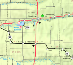
Sugarloaf is a ghost town in Sugar Loaf Township, Rooks County, Kansas, United States. [1]

History

Sugar Loaf (aka Sugarloaf) was issued a post office in 1878. The post office was renamed Sugarloaf in 1895. The Sugarloaf post office was discontinued in 1904. [2] The population in 1910 was 15. [3]

Related Research Articles

<span class="mw-page-title-main">Heber Springs, Arkansas</span> City in Arkansas, United States

Heber Springs is a city in and the county seat of Cleburne County, Arkansas, United States. The population was 7,165 at the 2010 census.

<span class="mw-page-title-main">Sugarloaf</span> Refined sugar molded into a conical shape for commercial distribution

A sugarloaf was the usual form in which refined sugar was produced and sold until the late 19th century, when granulated and cube sugars were introduced. A tall cone with a rounded top was the end product of a process in which dark molasses, a rich raw sugar that was imported from sugar-growing regions such as the Caribbean and Brazil, was refined into white sugar.

<span class="mw-page-title-main">Mount Sugarloaf (New South Wales)</span> Mountain in New South Wales, Australia

Mount Sugarloaf, also known as Great Sugar Loaf, is a mountain in the lower Hunter Region of New South Wales, Australia, standing at 412 metres, it looks over the cities of Newcastle, Lake Macquarie, Cessnock and Maitland. The summit of the mountain is in the Lake Macquarie suburb of West Wallsend and access to the summit is gained via this suburb. However, the mountain itself is also part of the city of Cessnock suburbs Mulbring and Richmond Vale. It is home to television transmitters that broadcast to the lower Hunter region. On 18 and 19 July 1965, the mountain received 10 centimetres (4 in) of snow. It also snowed on the summit in the winter of 1975.

<span class="mw-page-title-main">Sugar Loaf, Monmouthshire</span> Hill in Monmouthshire, Wales

The Sugar Loaf, sometimes called Sugar Loaf, is a hill situated 2 miles (3.2 km) north-west of Abergavenny in Monmouthshire, Wales and sits within the Brecon Beacons National Park. It is the southernmost of the summit peaks of the Black Mountains, with a height of 1,955 feet (596 metres). Sugar Loaf was gifted to the National Trust by suffragette Lady Rhondda.

<span class="mw-page-title-main">Sugarloaf Mountain</span> Peak in Rio de Janeiro, Brazil

Sugarloaf Mountain is a peak situated in Rio de Janeiro, Brazil, on a peninsula at the mouth of Guanabara Bay. Rising 396 m (1,299 ft) above the harbor, the peak is named for its resemblance to the traditional shape of concentrated refined loaf sugar. It is known worldwide for its cableway and panoramic views of the city and beyond.

<span class="mw-page-title-main">Sugarloaf Mountain (Maryland)</span> Mountain and park about 10 miles (16 km) south of Frederick, Maryland, USA

Sugarloaf Mountain is a small mountain and park about 10 miles (16 km) south of Frederick, Maryland. The closest village is Barnesville, located just over one mile from the foot of the mountain. The peak of this relatively low mountain is approximately 800 feet higher than the surrounding farmland. It is visible from many parts of northern Montgomery County and southern Frederick County, notably from I-270 north of the town of Germantown. Because of its geological and natural history interest, it was designated a National Natural Landmark in 1969. It is a notable example of an admission-free, privately owned scenic park.

<span class="mw-page-title-main">Great Sugar Loaf</span> Mountain in County Wicklow, Ireland

Great Sugar Loaf at 501 metres (1,644 ft), is the 404th–highest peak in Ireland on the Arderin scale, however, being below 600 m it does not rank on the Vandeleur-Lynam or Hewitt scales. The mountain is in the far northeastern section of the Wicklow Mountains, in Ireland, and overlooks the village of Kilmacanogue. The profile of the mountain means it can be mistaken for a dormant volcano. It owes its distinctive shape, however, to the erosion-resistant metamorphosed deep-sea sedimentary deposit from which its quartzite composition was derived.

<span class="mw-page-title-main">Sugarloaf (West Wicklow)</span> Mountain in Wicklow, Ireland

Sugarloaf is a 552 metres (1,811 ft) peak in west Wicklow, Ireland that lies on the northern edge of the Glen of Imaal. With a prominence of only 14 metres (46 ft), it is not listed in any of the recognised categories of mountains in Ireland, and is a subsidiary summit of Lobawn 636 metres (2,087 ft), to the north.

<span class="mw-page-title-main">Sugarloaf Hill (Putnam County, New York)</span> Mountain in New York, United States

Sugarloaf Hill is a 785 ft (239 m) peak along the Hudson River in Putnam County, New York, part of the Hudson Highlands. It was named by the Dutch for its resemblance in outline to a sugarloaf when sailing up the river towards it.

Sugarloaf is an unincorporated community residential area less than a mile south of Big Bear City and 8 miles from the eastern tip of Big Bear Lake in the San Bernardino Mountains of San Bernardino County, California. The area is primarily residential with a convenience store and a post office located at the center of the community. The residential area is set at an elevation of 7,096 feet at its center, whereas its extreme northern border is 6,998 feet above sea level and the southern tip sits at 7,218 feet above sea level. There is no municipal organization for the area, and all fire, water, and police service is provided by San Bernardino County. The ZIP code for the community is 92386, the area code 909, and the population is 1,816. Big Bear High School is located in the northern part of the community.

<span class="mw-page-title-main">Wilkie Sugar Loaf trail</span> 3.2-km. (return) hiking trail ascending Wilkie Sugar Loaf Mountain

The Wilkie Sugarloaf Trail is a hiking trail in northern Cape Breton Island in the Canadian province of Nova Scotia. The trail leads to the 411.8 metres (1,351 ft) summit of Wilkie Sugar Loaf in the Cape Breton Highlands.

A sugarloaf is refined sugar in the form of a rounded cone, the most common way of distributing sugar until the late 19th century.

Sugarloaf Mountain is a 1,348-foot (411 m) mountain located in Rowan County, Kentucky, just outside the City of Morehead, Kentucky.

<span class="mw-page-title-main">Sugarloaf Mound</span> United States historic place

Sugarloaf Mound is the sole remaining Mississippian culture platform mound in St. Louis, Missouri, a city commonly referred to in its earlier years as "Mound City" for its approximately 40 Native American earthen structures.

Sugarloaf is in the name of two different mountains that are located in Butte County of northern California.

<span class="mw-page-title-main">Sugarloaf, Colorado</span> Census-Designated Place in Colorado, United States

Sugarloaf is an unincorporated community and a census-designated place (CDP) located in and governed by Boulder County, Colorado, United States. The CDP is a part of the Boulder, CO Metropolitan Statistical Area. The population of the Sugarloaf CDP was 274 at the United States Census 2020. The Boulder post office serves the area.

<span class="mw-page-title-main">Wilkie Sugar Loaf</span> Mountain in Nova Scotia, Canada

Wilkie Sugar Loaf is a Canadian peak in the Cape Breton Highlands near the community of Sugar Loaf in the province of Nova Scotia.

<span class="mw-page-title-main">Township 5, Rooks County, Kansas</span> Township in Kansas, United States

Township 5 is a township in Rooks County, Kansas, United States.

<span class="mw-page-title-main">Sugar Loaf Island (California)</span> Island in California

Sugar Loaf Island, also known as Sugar Loaf, Cape Rock, Sugarloaf Island, Sugar Loaf Rock, and Sugarloaf Rock Island is an island offshore Cape Mendocino in Humboldt County, California. It is the westernmost island in California

References

  1. 1 2 "Sugarloaf, Kansas", Geographic Names Information System , United States Geological Survey, United States Department of the Interior
  2. "Kansas Post Offices, 1828-1961". Kansas Historical Society. Retrieved 2017-12-30.
  3. Blackmar, Frank Wilson (1912). Kansas: A Cyclopedia of State History, Volume 2, Chicago: Standard Publishing Company, p. 785