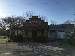
Cele, Texas

Last updated

Cele
Old Cele Store.jpg
Old Cele Store
USA Texas location map.svg
Red pog.svg
Cele
Location within the state of Texas
Usa edcp location map.svg
Red pog.svg
Cele
Cele (the United States)
Coordinates: 30°26′29″N97°31′21″W / 30.44139°N 97.52250°W / 30.44139; -97.52250
Country United States
State Texas
County Travis
Time zone UTC-6 (Central (CST))
  Summer (DST) UTC-5 (CDT)

Cele is a small unincorporated community in northeastern Travis County, Texas, United States. [1] It is located within the Greater Austin metropolitan area.

Contents

History

Cele was first settled in the 1890s. It was reportedly named for Lucille Custer, who was the daughter of a local store owner. A post office was established at Cele in 1896 and remained in operation until 1902, with an interruption in 1899. John Pitts Johns served as the postmaster. After the post office closed, mail was first sent to the community from New Sweden, but is now sent from Manor. Cele had a population of 25 from the 1930s to the 1960s and was still listed on county maps in 1990. [2]

It has one public business, the Cele Store, a barbecue restaurant, a bar, and an events facility. [3]

Geography

Cele is located two miles west of Farm to Market Road 973, 7 mi (11 km) north of Manor, 3 mi (4.8 km) east of Pflugerville, and 25 mi (40 km) away from downtown Austin in northeastern Travis County. [4]

Education

Today, the community is served by the Pflugerville Independent School District. Schools that are zoned for the community are Mott Elementary School, Cele Middle School, and Weiss High School.

Related Research Articles

<span class="mw-page-title-main">Travis County, Texas</span> County in Texas, United States

Travis County is located in south central Texas. As of the 2020 census, the population was 1,290,188. It is the fifth-most populous county in Texas. Its county seat and most populous city is Austin, the capital of Texas. The county was established in 1840 and is named in honor of William Barret Travis, the commander of the Republic of Texas forces at the Battle of the Alamo. Travis County is part of the Austin–Round Rock–Georgetown Metropolitan Statistical Area. It is located along the Balcones Fault, the boundary between the Edwards Plateau to the west and the Blackland Prairie to the east.

<span class="mw-page-title-main">Manor, Texas</span> City in Texas, United States

Manor is a city in Travis County, Texas, United States. Manor is located 12 miles northeast of Austin and is part of the Austin-Round Rock metropolitan area. The population was 13,652 at the 2020 census. Manor is one of the faster-growing suburbs of Austin. The city was the 7th fastest growing suburb in America in 2018 by Realtor.com and the 17th best small suburb to live in by U.S. News and World Report in 2019.

<span class="mw-page-title-main">Pflugerville, Texas</span> City in Texas, United States

Pflugerville is a city in Travis County, Texas, United States, with a small portion in Williamson County. The population was 65,191 at the 2020 census. Pflugerville is a suburb of Austin and part of the Austin–Round Rock– Metropolitan Statistical Area. It was named after the original German settlers who farmed the area; Pflüger means "plowman".

<span class="mw-page-title-main">Manchaca, Texas</span> Census-designated place in Texas, United States

Manchaca is an unincorporated community and census-designated place (CDP) in Travis County, Texas, United States. It is located 10 miles (16 km) southwest of downtown Austin. This was a new CDP for the 2020 census with a population of 2,266.

Pflugerville Independent School District (PfISD) is a public school district based in Pflugerville, Texas (USA). The District encompasses approximately ninety-five square miles and includes all or part of six municipalities including Pflugerville, Austin, Coupland, Hutto, Manor and Round Rock. As of 2013 PISD covers 10.7 square miles (28 km2) of land within the City of Austin, making up 3.4% of the city's territory.

Manor Independent School District (MISD) is a public school district based in Manor, Texas (USA). The district serves much of Manor, as well as a wide section of northeastern Austin and a small portion of Pflugerville. In 2022, the school district received a C rating from the Texas Education Agency.

<span class="mw-page-title-main">Hye, Texas</span> Unincorporated community in Texas, United States

Hye is an unincorporated community in western Blanco County, Texas, United States. According to the Handbook of Texas, the community had a population of 105 in 2000. Hye is part of the Texas-German belt and in very conservative rural Texas.

<span class="mw-page-title-main">McNeil, Travis County, Texas</span> Unincorporated community in Texas, United States

McNeil is an unincorporated community in Travis County, Texas, United States. According to the Handbook of Texas, the community had a population of 70 in 2000. It is located within the Greater Austin Metropolitan area. Its elevation is 830 feet (253 m).

<span class="mw-page-title-main">Cat Spring, Texas</span> Unincorporated community in Texas, United States

Cat Spring is an unincorporated community in southern Austin County, Texas, United States. According to the Handbook of Texas, it had a population of 76 in 2000. Cat Spring was one of the first German/American settlements in Texas, and the location of Texas' first agricultural society.

<span class="mw-page-title-main">Marshall Ford, Texas</span> Unincorporated community in Texas, United States

Marshall Ford is a small unincorporated community in Travis County, Texas, United States. It is located within the Greater Austin metropolitan area.

<span class="mw-page-title-main">New Sweden, Texas</span> Unincorporated community in Texas, United States

New Sweden is a small unincorporated community in northeastern Travis County, Texas, United States. It is located within the Greater Austin metropolitan area.

Bluff Springs is a small unincorporated community in southern Travis County, Texas, United States. According to the Handbook of Texas, the community had a population of 50 in 2000. It is located within the Greater Austin metropolitan area.

Campbellton is an unincorporated community in Atascosa County, Texas, United States. According to the Handbook of Texas, the community had an estimated population of 350 in 2000. Campbellton is part of the San Antonio Metropolitan Statistical Area.

Utley is an unincorporated community in Bastrop County, Texas, United States. According to the Handbook of Texas, the community had a population of 50 in 2000. It is located within the Greater Austin metropolitan area.

Littig is a small unincorporated community in eastern Travis County, Texas, United States. According to the Handbook of Texas, the community had a population of 37 in 2000. It is located within the Greater Austin metropolitan area.

Carl is an unincorporated community in Travis County, in the U.S. state of Texas. It is located within the Greater Austin metropolitan area.

Carlson is an unincorporated community in Travis County, in the U.S. state of Texas. According to the Handbook of Texas, the community had a population of 61 in 2000. It is located within the Greater Austin metropolitan area.

Dessau is an unincorporated community in Travis County, in the U.S. state of Texas. It is located within the Greater Austin metropolitan area.

Dunlap is an unincorporated community in Travis County, in the U.S. state of Texas. According to the Handbook of Texas, the community had a population of 80 in 2000. It is located within the Greater Austin metropolitan area.

Three Points is an unincorporated community in Travis County, in the U.S. state of Texas. It is located within the Greater Austin metropolitan area.

References

  1. U.S. Geological Survey Geographic Names Information System: Cele, Texas
  2. Cele, TX from the Handbook of Texas Online
  3. "Home". celestore.com.
  4. "Cele, Texas". Texas Escapes Online Magazine. Retrieved July 26, 2023.