Creedmoor, Texas

Last updated

Creedmoor, Texas
Creedmoor Community Center.jpg
Creedmoor Community Center
Travis County Creedmoor.svg
Location of Creedmoor, Texas
Coordinates: 30°5′32″N97°44′31″W / 30.09222°N 97.74194°W / 30.09222; -97.74194
Country United States
State Texas
County Travis
Area
[1]
  Total2.28 sq mi (5.91 km2)
  Land2.28 sq mi (5.91 km2)
  Water0.00 sq mi (0.00 km2)
Elevation
633 ft (193 m)
Population
 (2010)
  Total202
  Estimate 
(2019) [2]
224
  Density98.16/sq mi (37.89/km2)
Time zone UTC-6 (Central (CST))
  Summer (DST) UTC-5 (CDT)
Zip Code
78610
FIPS code 48-17612 [3]
GNIS feature ID1333645 [4]

Creedmoor is a city in Travis County, Texas, United States. The population was 202 at the 2010 census.

Contents

Geography

Creedmoor is located at 30°05′32″N97°44′31″W / 30.092094°N 97.741954°W / 30.092094; -97.741954 (30.092094, –97.741954), [5] approximately 15 miles south of Austin.

According to the United States Census Bureau, the city has a total area of 2.1 square miles (5.4 km2), all land.

Demographics

Historical population
CensusPop.Note
1990 194
2000 2118.8%
2010 202−4.3%
2019 (est.)224 [2] 10.9%
U.S. Decennial Census [6]

As of the census [3] of 2000, there were 211 people, 82 households, and 52 families residing in the city. The population density was 100.8 inhabitants per square mile (38.9/km2). There were 89 housing units at an average density of 42.5 per square mile (16.4/km2). The racial makeup of the city was 79.62% White, 0.95% African American, 16.59% from other races, and 2.84% from two or more races. Hispanic or Latino of any race were 47.39% of the population.

There were 82 households, out of which 29.3% had children under the age of 18 living with them, 48.8% were married couples living together, 11.0% had a female householder with no husband present, and 35.4% were non-families. 30.5% of all households were made up of individuals, and 13.4% had someone living alone who was 65 years of age or older. The average household size was 2.57 and the average family size was 3.30.

In the city, the population was spread out, with 23.2% under the age of 18, 5.7% from 18 to 24, 30.8% from 25 to 44, 25.1% from 45 to 64, and 15.2% who were 65 years of age or older. The median age was 39 years. For every 100 females, there were 93.6 males. For every 100 females age 18 and over, there were 88.4 males.

The median income for a household in the city was $39,688, and the median income for a family was $41,875. Males had a median income of $38,250 versus $28,958 for females. The per capita income for the city was $15,143. About 1.7% of families and 4.1% of the population were below the poverty line, including none of those under the age of eighteen and 17.6% of those 65 or over.

Education

Creedmoor Elementary School Creedmoor Elementary School.jpg
Creedmoor Elementary School

The City of Creedmoor is served by the Del Valle Independent School District. Creedmoor Elementary School is the newest elementary school in the district, and it has the largest attendance boundary of any district school. [7] Aside from that school, [8] [9] Ojeda Middle School, [10] Del Valle High School also serves the city.

Related Research Articles

<span class="mw-page-title-main">Del Aire, California</span> Census-designated place in California, United States

Del Aire is a census-designated place (CDP) in the inland South Bay, Los Angeles County, California, United States, between El Segundo and Hawthorne. The population was 10,001 at the 2010 census, up from 9,012 at the 2000 census.

<span class="mw-page-title-main">South El Monte, California</span> City in California, United States

South El Monte is a city in the San Gabriel Valley, in Los Angeles County, California, United States. At the 2010 census, the city had a population of 20,116, down from 21,144 at the 2000 census.

<span class="mw-page-title-main">Chubbuck, Idaho</span> City in Idaho, United States

Chubbuck is a city in Bannock County, Idaho. It is part of the Pocatello Metropolitan Statistical Area. The population was 13,922 at the 2010 census. Chubbuck is located immediately north of Pocatello, Idaho, and has opposed several consolidation proposals since the 1960s.

<span class="mw-page-title-main">Rickardsville, Iowa</span> City in Iowa, United States

Rickardsville is a city in Dubuque County, Iowa, United States. The population was 202 at the time of the 2020 census, up from 191 in 2000.

<span class="mw-page-title-main">Boyden, Iowa</span> City in Iowa, United States

Boyden is a city in Sioux County, Iowa, United States. The population was 701 at the 2020 census.

<span class="mw-page-title-main">Otho, Iowa</span> City in Iowa, United States

Otho is a city in Webster County, Iowa, United States. The population was 429 at the time of the 2020 census.

<span class="mw-page-title-main">Haysville, Kansas</span> City in Sedgwick County, Kansas

Haysville is a city in Sedgwick County, Kansas, United States, and a suburb of Wichita. As of the 2020 census, the population of the city was 11,262. Haysville is known as the "Peach Capital of Kansas".

<span class="mw-page-title-main">Albany, Minnesota</span> City in Minnesota, United States

Albany is a city in Stearns County, Minnesota, United States. The population was 2,561 at the 2010 census. It is part of the St. Cloud Metropolitan Statistical Area.

<span class="mw-page-title-main">El Valle de Arroyo Seco, New Mexico</span> CDP in New Mexico, United States

El Valle de Arroyo Seco is a census-designated place (CDP) in Santa Fe County, New Mexico, United States. It is part of the Santa Fe, New Mexico Metropolitan Statistical Area. The population was 1,440 at the 2010 census.

<span class="mw-page-title-main">Circle D-KC Estates, Texas</span> CDP in Texas, United States

Circle D-KC Estates is a census-designated place (CDP) in Bastrop County, Texas, United States. The population was 2,588 at the 2020 census.

<span class="mw-page-title-main">Wyldwood, Texas</span> CDP in Texas, United States

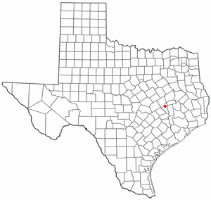
Wyldwood is a census-designated place (CDP) in Bastrop County, Texas, United States. The population was 3,694 at the 2020 census.

<span class="mw-page-title-main">Double Oak, Texas</span> Town in Texas, United States

Double Oak is a town in Denton County, Texas, United States. The population was 2,867 at the 2010 census.

<span class="mw-page-title-main">Hickory Creek, Texas</span> Town in Texas, United States

Hickory Creek is a town in Denton County, Texas, United States, located 30 miles (48 km) north of downtown Dallas. The population of Hickory Creek has grown from 219 at its incorporation in 1963 to 3,247 at the 2010 census. It is also one of the four communities in the Lake Cities.

<span class="mw-page-title-main">San Juan, Texas</span> City in Texas

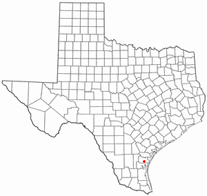
San Juan is a city in Hidalgo County, Texas, United States. As of the 2020 census the population was 35,294, up from 33,856 in 2010. It is part of the McAllen–Edinburg–Mission and Reynosa–McAllen metropolitan areas.
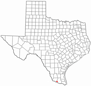
<span class="mw-page-title-main">Garceno, Texas</span> CDP in Texas, United States

Garceno is a census-designated place (CDP) in Starr County, Texas, United States. The population was 420 at the 2010 census down from 1,438 at the 2000 census.

<span class="mw-page-title-main">Garfield, Texas</span> CDP in Texas, United States

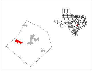
Garfield is a census-designated place (CDP) in Travis County, Texas, United States. As of the 2020 census, the CDP population was 1,825.

<span class="mw-page-title-main">Hudson Bend, Texas</span> CDP in Texas, United States

Hudson Bend is a census-designated place (CDP) in Travis County, Texas, United States. The population was 4,005 at the 2020 census.
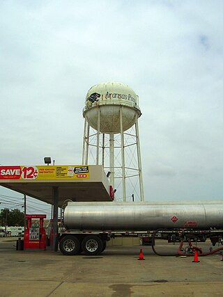
<span class="mw-page-title-main">Mustang Ridge, Texas</span> City in Texas, United States

Mustang Ridge is a city in Caldwell, Bastrop, and Travis Counties in the U.S. state of Texas. The population was 944 at the 2020 census.

<span class="mw-page-title-main">Ironton, Wisconsin</span> Village in Wisconsin, United States

Ironton is a village in Sauk County, Wisconsin, United States, along the Little Baraboo River. The population was 253 at the 2010 census. The village is located within the Town of Ironton.

<span class="mw-page-title-main">La Valle, Wisconsin</span> Village in Wisconsin, United States

La Valle is a village in Sauk County, Wisconsin, United States, along the Baraboo River. The population was 367 at the 2010 census. The village is located within the Town of La Valle.

References

  1. "2019 U.S. Gazetteer Files". United States Census Bureau. Retrieved August 7, 2020.
  2. 1 2 "Population and Housing Unit Estimates". United States Census Bureau. May 24, 2020. Retrieved May 27, 2020.
  3. 1 2 "U.S. Census website". United States Census Bureau . Retrieved January 31, 2008.
  4. "US Board on Geographic Names". United States Geological Survey. October 25, 2007. Retrieved January 31, 2008.
  5. "US Gazetteer files: 2010, 2000, and 1990". United States Census Bureau. February 12, 2011. Retrieved April 23, 2011.
  6. "Census of Population and Housing". Census.gov. Retrieved June 4, 2015.
  7. "Creedmoor Elementary Archived 2009-03-24 at the Wayback Machine ." Del Valle Independent School District. Retrieved on May 8, 2011.
  8. "p448198787_8588.jpg" (Archive). Del Valle Independent School District. Retrieved on August 24, 2016.
  9. "2010 CENSUS - CENSUS BLOCK MAP: Creedmoor city, TX." U.S. Census Bureau. Retrieved on August 24, 2016.
  10. "2014/15 Attendance Boundaries." Del Valle Independent School District. Retrieved on August 24, 2016.