
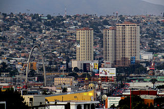
Tijuana, known also by the initials T.J., is a city and municipal seat of Tijuana Municipality, Baja California, located on the Pacific Coast of Mexico. It is part of the San Diego-Tijuana metro area and the larger Southern California megapolitan area.

Coyoacán is a borough in Mexico City. The former village is now the borough's "historic center". The name comes from Nahuatl and most likely means "place of coyotes", when the Aztecs named a pre-Hispanic village on the southern shore of Lake Texcoco dominated by the Tepanec people. Against Aztec domination, these people welcomed Hernán Cortés and the Spanish, who used the area as a headquarters during the Spanish conquest of the Aztec Empire and made it the first capital of New Spain between 1521 and 1523.

Santiago de Querétaro, known simply as Querétaro City, is the capital and largest city of the state of Querétaro, located in central Mexico. It is part of the macroregion of Bajío. It is 213 kilometers (132 mi) northwest of Mexico City, 63 kilometers (39 mi) southeast of San Miguel de Allende and 200 kilometers (120 mi) south of San Luis Potosí. It is also the seat of the municipality of Querétaro, divided into seven boroughs. In 1996, the historic center of Querétaro was declared a World Heritage Site by the UNESCO.
Chinatowns in Latin America developed with the rise of Chinese immigration in the 19th century to various countries in Latin America as contract laborers in agricultural and fishing industries. Most came from Guangdong Province. Since the 1970s, the new arrivals have typically hailed from Hong Kong, Macau, and Taiwan. Latin American Chinatowns may include the descendants of original migrants — often of mixed Chinese and Latino parentage — and more recent immigrants from East Asia. Most Asian Latin Americans are of Cantonese and Hakka origin. Estimates widely vary on the number of Chinese descendants in Latin America but it is at least 1.4 million and likely much greater than this.

Tijuana Municipality is a municipality in the Mexican state of Baja California. Its municipal seat is located in the city of Tijuana. According to the 2020 census, the municipality had a population of 1,922,523. Luis Arturo González Cruz of the MORENA is the current municipal president. The municipality comprises the largest part of the Tijuana metropolitan area.

Colonia Roma, also called La Roma or simply, Roma, is a district located in the Cuauhtémoc borough of Mexico City just west of the city's historic center, and in fact is no longer a single colonia (neighbourhood) but now two officially defined ones, Roma Norte and Roma Sur, divided by Coahuila street.

Colonia del Valle is a neighborhood in the Benito Juarez borough of Mexico City. It includes "...a great number of parks, vast and tree-lined streets, prestigious shopping malls, and some city landmarks...".

Avenida Revolución is the tourist center in Tijuana, Baja California, México. It is a main thoroughfare of the historic downtown of Tijuana, officially called the Zona Centro, which forms part of the Delegación Centro or Central Borough of Tijuana.
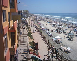
Playas de Tijuana is the westernmost borough of the municipality of Tijuana, Baja California, stretching from the United States border in the north to Rosarito Beach Municipality in the south. The Bullring by the Sea was opened in 1960.

Zona Norte is an official neighborhood, as well as a red light district located in Tijuana, Mexico. It is among the largest red-light districts in North America known for its brothels, which present themselves in public as strip clubs and bars, similar to gentlemen's clubs in the United States.
Zona Río is an official zone, and the main modern business district, of the city of Tijuana, Mexico.
Colonia Juárez is one of the better–known neighborhoods or colonias in the Cuauhtémoc borough of Mexico City. The neighborhood is shaped like a long triangle with the boundaries: Paseo de la Reforma on the north, Avenida Chapultepec on the south, and Eje 1 Poniente on the east.

Centro is a neighborhood in the Central Region of Rio de Janeiro, Brazil. It represents the financial heart of the city, and the crux of the Central Region.

Zona Central is the historical, administrative, and financial centre of the city of Rio de Janeiro, Brazil. It has been undergoing a major revitalisation since it was rediscovered by locals in the 1990s.
Otay Centenario is a borough of the municipality of Tijuana in Baja California, Mexico. It is the result of a merger between the former boroughs of Mesa de Otay and Centenario which took place on January 1, 2014.

Agua Caliente is a historic entertainment center and present-day district of Tijuana, Baja California, at the southeastern end of the Centro borough. The Agua Caliente Tourist Complex formed in the late 1920s along Agua Caliente Boulevard when a road was built that led from the historic Rio Zone to a natural hot springs two miles up the Tijuana River Valley. Paramount icons of Tijuana developed in Agua Caliente such as the Agua Caliente Casino and Hotel and the Agua Caliente Racetrack. Today Agua Caliente is one of Tijuana's paramount tourist centers, the location of some of the city's most affluent neighborhoods, and also contains commercial and other offices along Boulevard Agus Caliente.
Downtown Tijuana, officially Colonia Zona Centro, is an official neighborhood of Tijuana, Mexico. It is located within the Central Borough of the city, immediately southwest of the San Ysidro Port of Entry. It is bordered by Calle Artículo 123 and the Zona Norte neighborhood on the north, by Calle Ocampo and Zona Este and Zona Río on the east, and by the colonias (neighborhoods) Castillo, Lindavista, Altamira, Independencia, Morelos, and Juárez on the west and south. Avenida Revolución is the main tourist thoroughfare while Avenida Constitución is a main traditional shopping thoroughfare.
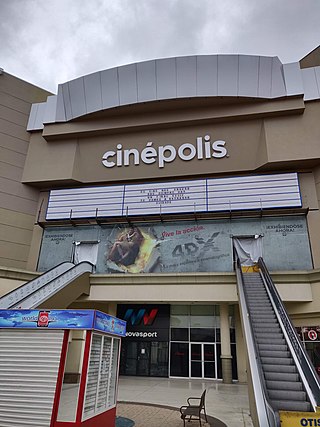
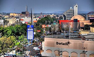
Plaza Río Tijuana is an open-air shopping center in the Zona Río of Tijuana, Baja California, Mexico. It has a surface area of 792,000 square feet (73,579 m2). It opened in 1981 as the first large American-style mall in the city; previously Downtown Tijuana was the leading shopping area. Currently, it has the anchors Soriana, Sears, and Cinépolis. There was a Dorian's department store here until 2009 when it became Sears. Comercial Mexicana was also in the mall until it became Soriana in 2018.

Dorian's was a department store chain based in Tijuana, Baja California, Mexico.

