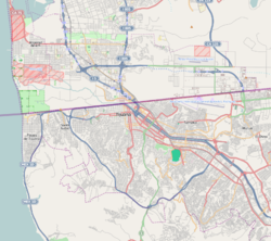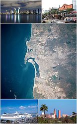
Tijuana is the most populous city in the state of Baja California, located on the northwestern Pacific Coast of Mexico. Tijuana is the municipal seat of the Tijuana Municipality and the hub of the Tijuana metropolitan area. It has a close proximity to the Mexico–United States border which is part of the San Diego–Tijuana metro area.
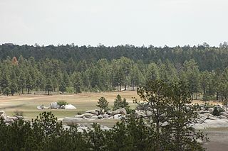
Baja California, officially the Free and Sovereign State of Baja California, is a state in Mexico. It is the northwesternmost of the 32 federal entities of Mexico. Before becoming a state in 1952, the area was known as the North Territory of Baja California. It has an area of 70,113 km2 (27,071 sq mi) and comprises the northern half of the Baja California peninsula, north of the 28th parallel, plus oceanic Guadalupe Island. The mainland portion of the state is bordered on the west by the Pacific Ocean; on the east by Sonora, the U.S. state of Arizona, and the Gulf of California; on the north by the U.S. state of California; and on the south by Baja California Sur.

Mexicali is the capital city of the Mexican state of Baja California. The city, which is the seat of the Mexicali Municipality, has a population of 689,775, according to the 2010 census, while the Calexico–Mexicali metropolitan area is home to 1,000,000 inhabitants on both sides of the Mexico–United States border. Mexicali is a regional economic and cultural hub for the border region of The Californias.

Tijuana Municipality is a municipality in the Mexican state of Baja California. Its municipal seat is located in the city of Tijuana. According to the 2020 census, the municipality had a population of 1,922,523. Montserrat Caballero of the MORENA is the current mayor. The municipality comprises the largest part of the Tijuana metropolitan area.

The South Bay, also known as South County, is a region in southwestern San Diego County, California, consisting of the cities and unincorporated communities of Bonita, Chula Vista, East Otay Mesa, Imperial Beach, Lincoln Acres, National City, and South San Diego.
Otay Mesa is a community in the southern exclave of San Diego, California, just north of the U.S.–Mexico border.

San Diego–Tijuana is an international transborder agglomeration, straddling the border of the adjacent North American coastal cities of San Diego, California, United States, and Tijuana, Baja California, Mexico. The 2020 population of the region was 5,456,577, making it the largest bi-national conurbation shared between the United States and Mexico, and the second-largest shared between the US and another country. The conurbation consists of San Diego County, in the United States and the municipalities of Tijuana, Rosarito Beach (126,980), and Tecate (108,440) in Mexico. It is the third most populous region in the California–Baja California region, smaller only than the metropolitan areas of Greater Los Angeles and the San Francisco Bay Area.
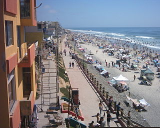
Playas de Tijuana is the westernmost borough of the municipality of Tijuana, Baja California, stretching from the United States border in the north to Rosarito Beach Municipality in the south. The Bullring by the Sea was opened in 1960.
The Hardy River is a 26-kilometer (16 mi)-long Mexican river formed by residual agricultural waters from the Mexicali Valley, and running into the Colorado River. The river is believed to have been an ancient channel of the Colorado, as well as the primary outflow for the prehistoric Lake Cahuilla.

The San Ysidro Mountains are a mountain range in southern San Diego County, California, and Baja California, Mexico. The mountains are a rugged coastal foothill range of the Peninsular Ranges system. Major peaks include the highest summit of the range, Otay Mountain, and the Cerro San Isidro which forms the southern extrusion of the range on the Mexican side of the border. The majority of the range is within the Otay Mountain Wilderness area, in the United States.

The Imperial Fault Zone is a system of geological faults located in Imperial County in the Southern California region, and adjacent Baja California state in Mexico. It cuts across the border between the United States and Mexico.
Cerro Prieto is a volcano located approximately 29 km (18 mi) SSE of Mexicali in the Mexican state of Baja California. The volcano lies astride a spreading center associated with the East Pacific Rise. This spreading center is also responsible for a large geothermal field, which has been harnessed to generate electric power by the Cerro Prieto Geothermal Power Station.
The Cerro Prieto Fault is a transform fault located in far northern Baja California. It runs between the Cerro Prieto spreading center located southwest of Mexicali, and the Wagner Basin, another spreading center which lies under the Gulf of California. These spreading centers are part of the East Pacific Rise, the northern leg of which has formed the Gulf of California by steadily rifting the Baja California peninsula away from the mainland of Mexico.
Otay Centenario is a borough of the municipality of Tijuana in Baja California, Mexico. It is the result of a merger between the former boroughs of Mesa de Otay and Centenario which took place on January 1, 2014.
La Presa is a borough of the municipality of Tijuana in Baja California, Mexico. The La Presa borough is named after the Abelardo L. Rodríguez Dam, but actually does not include the dam within its boundaries. The borough should not be confused with the neighborhoods (colonias) that have La Presa in their name northwest of the dam; those form part of the La Mesa borough. La Presa borough includes the El Florido industrial park and several neighborhoods with El Florido in the name. La Presa borough is bordered by Centenario (borough) on the north and Cerro Colorado (borough) on the west.
Cerro Colorado is Spanish for red mountain/hill. It may refer to:

The Pacific Coast of Mexico or West Coast of Mexico stretches along the coasts of western Mexico at the Pacific Ocean and its Gulf of California.
Club Inter de Tijuana was a Mexican football team that competed in Ascenso MX. They played in the Estadio del Cerro Colorado in Tijuana, Baja California, Mexico.

The Cerro Bola is a coastal metavolcanic mountain formation in northwestern Baja California. The Cerro Bola, along with the nearby mountain Cerro Gordo form the highest elevation areas of Tijuana Municipality. Because of its prominence, the transmitters for television station XHDTV and radio station XHPRS-FM are located on the summit of Cerro Bola, which reaches an elevation of 1,260 m (4,130 ft). It is located approximately 35 km (22 mi) south of the Tecate border crossing, and sits at the southwest end of the Valle de Las Palmas. The mountain range is host to a number of rare and endemic plant species, such as Arctostaphylos bolensis and Ceanothus bolensis.

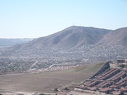
Cerro Colorado is a mountain located in the city of Tijuana. It is one of the highest elevations within the urban area and the most iconic due to its shape and location.
