Chaffee Park, Denver

Last updated
Chaffee Park, Denver, Colorado
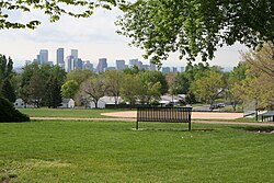
ZuniPark.JPG
A view towards downtown Denver from 51st and Zuni Park (Zuni Park) in the Chaffee Park Neighborhood.
Chaffee Park neighborhood in Denver, Colorado, USA.gif
Location in the City of Denver
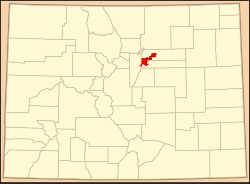
Map of Colorado highlighting Denver County (colored).svg
Location of Denver in the state of Colorado
Coordinates: 39°47′15″N105°00′57″W / 39.7874°N 105.0158°W / 39.7874; -105.0158 (Chaffee Park, Denver)
Country Flag of the United States (23px).png  United States
State Flag of Colorado.svg  Colorado
County Denver
Elevation
5,319 ft (1,621 m)
Website chaffeepark.org

Chaffee Park is a neighborhood in Denver, Colorado located in the northwest corner of the city. Chaffee Park is north of Sunnyside connected via Zuni Street, and northeast of Berkeley connected through Regis via nearby Lowell Boulevard. Chaffee Park is east of Regis and south of Adams County.

Contents

Chaffee Park earned Sustainable Neighborhood designation from the City and County of Denver in February 2014. [1] Residents are represented by the Chaffee Park Neighborhood Association, which is a Registered Neighborhood Organization (RNO) with the city. [2]

There is another Denver city park named Chaffee Park that is located in Sunnyside (south of the Chaffee Park neighborhood). The main park in Chaffee Park is called 51st and Zuni Park, although commonly referred to as Zuni Park.

Geography

Boundaries

The neighborhood's boundaries are: [3]

Zoning

The majority of the neighborhood is zoned as single unit residential properties with allowance for accessory dwelling units (ADUs) (also known as carriage houses, granny flats, or English basements). The average price per square foot in August 2018 was $340 with an average asking price (for new listings) of $439,633. [4] At the heart of the neighborhood is Zuni Park, which is a zoned open space park. [5] There are several smaller zoned commercial corridors on the western and southeastern edges of the neighborhood, one near the neighborhood center at 49th Avenue and Zuni Street, and a commercial/residential mixed use area in the northwest corner of the neighborhood. There is a zoned area of industrial mixed use and industrial commercial properties on the eastern edge of the neighborhood spanning Osage Street to Kalamath Street. [6] [7] [8] [9]

In November 2020 the Denver City Council unanimously approved rezoning the Chaffee Park neighborhood to allow ADUs. The Chaffee Park Neighborhood Association worked with Councilwoman Amanda Sandoval to bring to the full council the measure, which will allow residential property owners to have a smaller home on a lot that is zoned for a single family home. The measure is consistent with the City Council's Blueprint Denver land use and transportation policy document, easing zoning to provide more housing. In Chaffee Park, ADUs are intended to bring down the cost of each unit of housing by increasing the number of housing units on a fixed number of lots. In practice this commonly means providing transitional housing for aging parents and adult children starting their careers. [10]

Transportation

Chaffee Park has access to major roads and highways that connect the Denver metropolitan area, including: Federal Boulevard, Pecos Street and I-70. The neighborhood has nearby access to I-25 via I-70, I-76 via Federal Boulevard and Pecos Street, and US-36 via Federal Boulevard and Pecos Street.

Denver's Regional Transportation District (RTD) has three local bus routes serving the Chaffee Park neighborhood: [11] [12]

Denver's D-3 Regional Bike Route spans the neighborhood along Zuni Street, from 52nd Avenue south to the adjacent Sunnyside neighborhood, connecting to D-5 at 46th Avenue. [16]

A 3.5 mile "Wellness Loop" pedestrian/bike path connects Chaffee Park with Regis neighborhood to its west, featuring several points of interest, including: Clear Creek Trail, Rocky Mountain Park, and the Sister Gardens at Aria. The Wellness Loop was sponsored by Cultivate Health, The Colorado Health Foundation, WalkDenver and the City of Denver. [17]

History

In the early 20th century, the area now known as Chaffee Park was a semi-rural area of truck farms interspersed with houses. [18] Chaffee Park was then named after Jerome B. Chaffee, one of the founders of the City of Denver and Republican U.S. Senator from November 1876 to March 1879.

In April 1946 the Denver City Council approved the development plan for the Chaffee Park Heights Subdivision submitted by developer Garrett-Bromfield & Co. with initial boundaries between 48th and 52nd Avenues and between Tejon Street and Pecos Street. Chaffee Park was platted over the course of 1945–52, but was mostly completed by 1949. There was so much demand for building supplies in the United States during this period that contractors bartered with other companies around the country for materials during construction. Given the demand for post-war housing, the first 412 homes in the community were only available to U.S. military veterans with children. Numerous residents of the newly developed Chaffee Park neighborhood were second-generation Italian-Americans who were served by the nearby Guardian Angels Catholic Church of Denver that was established in 1953. [19] [20] [21]

The homes were built in the Minimal Traditional-style, loosely based on the Tudor Revival-style of the 1920s and 1930s. These one-story homes are typically boxy in appearance with a simple façade, and often feature front facing gable section or gabled cover entries and a low- or intermediate-pitch roof. [22] Overall, this type of development was common in Denver in the Post-War Period. The five-county Denver region experienced a 146% population increase between 1940 and 1965, from 407,962 residents to over one million. [23]

Demographics

According to the Piton Foundation, in 2007, the population of the neighborhood was 4,401, and there were 1,554 housing units. [24] In the year 2000, the racial breakdown was 31.44% White, 0.91% African American, 64.13% Hispanic or Latino, 0.91% Native American, and 0.94% Asian. [24]

Landmarks

Zuni Park

Zuni Park is located at the northern edge of Chaffee Park Neighborhood between Zuni Street and Vallejo Street, south of West 52nd Avenue. [25] Zuni Park features: a bike/pedestrian path, multiple picnic areas, a drinking fountain, restrooms, shelter, a basketball court, a playground, mixed-use field space, a baseball/softball field, and an outdoor fitness equipment area (one of The Trust for Public Land's Fitness Zone® program areas). The Fitness Zone was developed as a part of a partnership between nearby Regis University and The Trust for Public Land, who installed the equipment in March 2016 in coordination with Denver Parks and Recreation. [26] [27]

Zuni Park is technically unnamed and referred to as 51st & Zuni Park by the Denver Parks and Recreation Department, however it is colloquially known as Zuni Park. [28]

Beach Court Elementary

Beach Court Elementary originally opened in 1921 at West 46th Avenue and Alcott Street utilizing three temporary structures, a fourth was added in 1927 however all four temporary buildings were taken down and replaced with a permanent building in 1929. [29] In its first iteration, the school featured three bungalows and one kindergarten room serving approximately 100 students. [30] Rapid enrollment at the school led to the design and construction of a new building at West 46th Avenue and Beach Court in 1929–30, designed by architect G. Meredith Musick, with six classrooms and one kindergarten. [31]

The neighborhood experienced continued growth and Musick oversaw an addition to the school in 1949–51, dedicated on May 21, 1951. At the time of the addition, approximately 600 students attended Beach Court Elementary. [32] In 1951 the school grew to seven classrooms and two kindergarten rooms. Additional facilities were added, including the: library, gymnasium, kitchen, clinic, conference room, office, and teacher's lounge. Educational programming expanded to include audio-visual aids, health programs, film and movie equipment, a band, and orchestra lessons. The school also functioned as a community center, used by organizations like the Boy Scouts, Girl Scouts, and the Red Cross, for sewing, first aid, nutrition, and other classes. [33]

The school grew to twenty-two classrooms in 1993, with an addition designed by architecture firm JH/P Architecture and built by Ward Construction. The school also moved to a student-centered environment with the State of Colorado's student performance standards. [34] [35]

In October 2016 Beach Court Elementary was among the first Denver Public Schools (DPS) to receive a SmartLab, after a competitive application process. This addition to the schools' educational offerings was made possible by a donation from DPS alumni Marco Campus, with the remaining half of matching funds coming from DPS and the DPS Foundation. [36] [37] SmartLabs offer project-based, student-centered curriculum supporting STEM and other core academic content. SmartLabs are a part of DPS CareerConnect's STEMConnect partnership with DPS Curriculum and Instruction with the aim of getting students interested in STEM careers at an early age. [38]

Beach Court Elementary's school colors are blue and white and their mascot is the eagle. [34]

Chaffee Park Shopping Center

The Chaffee Park Shopping Center, located near West 48th Avenue and Pecos Street, opened in 1947–1949. The development was led by real estate firm Garrett-Bromfield & Co. and originally featured middle-class retail outlets such as a Safeway grocery store and a J.C. Penney department store. Developers were confident that residential real estate construction for veterans returning from World War II would fill in the housing blocks adjacent to the complex, which happened shortly thereafter. [39] [40]

Zuni Plaza

Zuni Plaza is an upcoming development in the heart of Chaffee Park (49th Avenue and Zuni Street) at a vacant church originally built in 1952. The project is converting the building and parking area into a commercial space for retail, restaurants, and a dedicated artist studio within the former church building. While Chaffee Park grew after the city's streetcar system connecting north Denver was dismantled, Zuni Plaza will serve as an extension of the revitalized former streetcar commercial nodes spanning north Denver along Zuni Street (which connects the Chaffee Park, Sunnyside, Highland, and Jefferson Park neighborhoods). The Zuni Plaza project is led by Denver-based developers Columbia Group and Paul Tamburello (founder of Little Man Ice Cream in LoHi and dubbed the "father of the rejuvenated Highland" by The Denver Post.) [41] [42]
Skyline Festival

Chaffee Park's annual Skyline Festival in Zuni Park is a community event featuring: exercise, games, food trucks, pot luck food share, children's activities, booths from local community organizations and vendors, and live music. [43] Founded in 2017 by residents of the community, the Skyline Festival is one of many events associated with the city of Denver's Denver Days program. [44]

Related Research Articles

<span class="mw-page-title-main">Colorado Springs, Colorado</span> City in Colorado, United States

Colorado Springs is a city in and the county seat of El Paso County, Colorado, United States. It is the most populous city in El Paso County, with a population of 478,961 at the 2020 census, a 15.02% increase since 2010. Colorado Springs is the second-most populous city and the most extensive city in the state of Colorado, and the 39th-most-populous city in the United States. It is the principal city of the Colorado Springs metropolitan area, which had 755,105 residents in 2020, and the second-most prominent city of the Front Range Urban Corridor. It is located in east-central Colorado on Fountain Creek, 70 miles (113 km) south of Denver.

<span class="mw-page-title-main">Denver</span> Capital of Colorado, United States

Denver is a consolidated city and county, the capital, and most populous city of the U.S. state of Colorado. It is located in the western United States, in the South Platte River Valley on the western edge of the High Plains east of the Front Range of the Rocky Mountains. With a population of 715,522 as of the 2020 census, a 19.22% increase since 2010, Denver is the 19th most populous city in the United States and the fifth most populous state capital. It is the principal city of the Denver–Aurora–Lakewood metropolitan statistical area, with almost 3 million people the most populous metropolitan area in Colorado. Denver is the economic and cultural center of the broader Front Range Urban Corridor, home to more than 5 million people.

<span class="mw-page-title-main">Glendale, Colorado</span> City in Colorado, United States

The City of Glendale is a home rule municipality located in an exclave of Arapahoe County, Colorado, United States. The city population was 4,613 at the 2020 United States Census. Glendale is an enclave of the City and County of Denver and is the most densely populated municipality in Colorado. The city is a part of the Denver–Aurora–Lakewood, CO Metropolitan Statistical Area and the Front Range Urban Corridor.

<span class="mw-page-title-main">Sunnyside, Queens</span> Neighborhood in New York City

Sunnyside is a neighborhood in the western portion of the New York City borough of Queens. It shares borders with Hunters Point and Long Island City to the west, Astoria to the north, Woodside to the east and Maspeth to the south. It contains the Sunnyside Gardens Historic District, one of the first planned communities in the United States.

<span class="mw-page-title-main">Capitol Hill, Denver</span> Neighborhood in Denver, Colorado, United States of America

Located in the city and county of Denver, Colorado, the Capitol Hill neighborhood is bordered by Broadway, Downing Street, Colfax Avenue, and Seventh Avenue, which carry large volumes of traffic around the neighborhood. It is technically located in East Denver which begins immediately east of Broadway, the neighborhood's western boundary. Many consider the Cheesman Park neighborhood to be a part of the Capitol Hill neighborhood, but as defined by the city, Cheesman Park is a separate neighborhood. Denver also recognizes a statistical neighborhood called North Capitol Hill, also known as Uptown by some residents. Colfax Avenue is the border between these two neighborhoods.

<span class="mw-page-title-main">Denver Public Schools</span> Public school system in Colorado, U.S.

The School District No. 1 in the City and County of Denver and State of Colorado, more commonly known as Denver Public Schools (DPS), is the public school system in the City and County of Denver, Colorado, United States.

<span class="mw-page-title-main">Sunnyside, Houston</span>

Sunnyside is a community in southern Houston, Texas, United States, south of Downtown Houston.

<span class="mw-page-title-main">Park Hill, Denver</span> Neighborhood in Denver, Colorado, United States of America

Park Hill is a neighborhood in Denver, Colorado, U.S. Located in the northeastern quadrant of the city, it is bordered by Colorado Boulevard on the west, East Colfax Avenue on the south, Quebec Street on the east, and East 52nd Avenue on the north. The entire Park Hill neighborhood is located in the area known as East Denver. It is further divided by the City and County of Denver into three administrative neighborhoods, South Park Hill, North Park Hill, and Northeast Park Hill.

<span class="mw-page-title-main">Jefferson Park, Denver</span>

Jefferson Park is a neighborhood and public park that overlooks Downtown Denver, Colorado from its perch across Interstate 25 (I-25). It is located in the area that is called North Denver. Views east from Jefferson Park take in Elitch Gardens Theme Park, The Children's Museum, Denver's Downtown Aquarium, Pepsi Center, the REI flagship store and other attractions in Downtown's Central Platte Valley. Downtown Denver and the Central Platte Valley are quickly accessed from Jefferson Park, using the 23rd Avenue overpass on I-25 and Water Street. In addition, the Light Rail C-Line is located by Empower Field at Mile High in the southern part of the neighborhood.

<span class="mw-page-title-main">Highland, Denver</span>

Highland is a distinct city-center neighborhood in Denver, Colorado, United States, bounded by West 38th Avenue to the north, a Union Pacific Railroad line on the east, the South Platte River to the southeast, Speer Boulevard on the south, and Federal Boulevard on the west. The Highlands is sometimes used to refer to two separate city-center neighborhoods in Denver; Highland and West Highland, although the two neighborhoods are distinct. Highland and West Highland are both in the area that is referred to as the Northside. Highland is located immediately northwest of downtown. Note that the Highland neighborhood association has a slightly different definition with the easternmost boundary stopping at I-25. And the West Highland neighborhood to the immediate west of Highland, with the borders of 38th and 29th Avenues on the north and south and Federal and Sheridan Boulevards on the east and west. To distinguish between its immediately adjacent neighbor, West Highland, Highland is sometimes referred to as East Highland, Lower Highland or LoHi. The two together are casually called "the Highlands," a term which often falsely encompasses other Northwest Denver neighborhoods such as Jefferson Park, Sunnyside and Berkeley. Realtors have particularly pushed the inclusion of the recently gentrified Berkeley, located directly north of West Highland, as part of the Highlands, sometimes going so far as to refer to Berkeley and parts of Sunnyside as the "Upper Highlands". To add further confusion, within the Highlands neighborhoods there are several historic designations of various degrees, including Potter Highlands, Scottish Highlands and Highlands Park.

<span class="mw-page-title-main">Street system of Denver</span> Dual street grid system in Denver, CO

The oldest part of Denver, Colorado, now the neighborhoods of Auraria Campus, LoDo, much of downtown, and Five Points, is laid out on a grid plan that is oriented diagonal to the four cardinal directions. The rest of the city, including the eastern part of downtown, is laid out primarily on a grid oriented to the cardinal directions. In this larger grid, from east to west, there are generally 16 city blocks per mile, except between Zuni Street and Lowell Boulevard in west Denver. From north to south, there are typically eight blocks per mile, although there are many areas with more blocks per mile. Addresses follow a decimal system, with addresses advancing by one hundred at each cross street.

<span class="mw-page-title-main">Sunnyside, Denver</span> Neighborhood in Denver, Colorado

Sunnyside is a city-center neighborhood in Denver, Colorado, located in the Northside of Denver, west of Interstate 25.

<span class="mw-page-title-main">Berkeley, Denver</span> Neighborhood in Denver, Colorado, US

Berkeley is a city-center neighborhood in Denver, Colorado, located in the area traditionally called the, "Northside", on the west side of Interstate 25 and just south of Interstate 70.

<span class="mw-page-title-main">Athmar Park, Denver</span> Neighborhood in Denver, Colorado

Athmar Park is a residential neighborhood in southwest Denver, Colorado. It consists mostly of all-brick ranches and bungalow-style homes built in the 1940s and 1950s.

<span class="mw-page-title-main">Denver Harbor, Houston</span> Historic community in Houston, Texas, US

Denver Harbor is a historic community located in eastern Houston, Texas, United States near the Houston Ship Channel. The community, bounded by Wallisville Road, the Union Pacific Railroad, and the Port Terminal Railroad Association, was first settled in the 1890s and platted in 1911 and 1913. The community includes many historic bungalow and cottage homes.

<span class="mw-page-title-main">Lincoln Park, Denver</span> Neighborhood in Denver, Colorado, United States of America

Lincoln Park is a neighborhood and public park close to downtown Denver, Colorado and the location of the Art District on Santa Fe. The neighborhood is one of Denver's oldest and is just to the south of the area where Denver was first settled in the 1850s. Many houses date from about 1900. The neighborhood is sometimes called "La Alma/Lincoln Park" or the West Side.

The North Side (Denver) is a region in Denver County. It is also known as North Denver. The neighborhoods located within Denver's North Side are Sloan's Lake, West Highland, Berkeley, Regis, Chaffee Park, Sunnyside, Highland, and Jefferson Park.

Regis is a neighborhood in Denver. Located in North Denver, its boundaries are Harlan Street to the west, Clear Creek (Colorado) to the northwest, 52nd Avenue and the northern border of the Regis University campus to the north, Federal Boulevard to the east, and highway I-70 to the south. The Berkeley neighborhood is adjacent to its south end and the Chaffee Park neighborhood is adjacent to its east end. Located in the neighborhood is Regis University and the Willis Case golf course.

The Denver North Star is a monthly newspaper and website that has been published in the Northwest Denver, Colorado, area starting in October 2019. The North Star has a hyperlocal focus on issues like parks and recreation, elections, education, dining, zoning, and development.

References

  1. Vaccarelli, Joe (July 21, 2015). "Denver's Sustainable Neighborhood Program adding new members". The Denver Post. Archived from the original on August 12, 2018. Retrieved August 12, 2018.
  2. "Denver's Registered Neighborhood Organizations (RNOs)". City of Denver Community and Planning Development. August 12, 2018. Retrieved August 12, 2018.
  3. "City and County of Denver Statistical Neighborhoods" (PDF). City and County of Denver. January 2013. Archived from the original (PDF) on March 19, 2017. Retrieved August 13, 2018.
  4. "Chaffee Park Neighborhood Data". August 12, 2018.
  5. "City and County of Denver Zoning Map Quarter Section: NW_045" (PDF). May 14, 2018. Archived from the original (PDF) on August 18, 2018. Retrieved August 18, 2018.
  6. "City and County of Denver Zoning Map Quarter Section: NW_046" (PDF). May 14, 2018. Archived from the original (PDF) on August 18, 2018. Retrieved August 18, 2018.
  7. "City and County of Denver Zoning Map Quarter Section: NW_044" (PDF). May 14, 2018. Archived from the original (PDF) on August 18, 2018. Retrieved August 18, 2018.
  8. "Zoning". City of Denver Maps. Retrieved August 18, 2018.
  9. "Zone District Descriptions & Definitions". City of Denver Community and Planning Development. Retrieved August 18, 2018.
  10. Bryson, Donna (9 November 2020). "Chaffee Park rezoned in one swoop to allow ADUs". Denverite. Denverite. Archived from the original on 10 November 2020. Retrieved 10 November 2020.
  11. "RTD System Map". Regional Transportation District Denver. Retrieved August 18, 2018.
  12. "RTD Schedules Effective May 20, 2018". Regional Transportation District Denver. Retrieved August 18, 2018.
  13. "Route 19: North Pecos" (PDF). Regional Transportation District Denver. November 2017. Archived from the original (PDF) on August 18, 2018. Retrieved August 18, 2018.
  14. "Route 31: Federal Crosstown" (PDF). Regional Transportation District Denver. January 14, 2018. Archived from the original (PDF) on August 18, 2018. Retrieved August 18, 2018.
  15. "Route 52: West 52nd Avenue/South Bannock" (PDF). Regional Transportation District Denver. November 2017. Archived from the original (PDF) on August 18, 2018. Retrieved August 18, 2018.
  16. "Denver Bike Map (2017)" (PDF). City of Denver Bicycling in Denver: Bicycling Resources, Bike Maps. 2017. Archived from the original (PDF) on October 3, 2017. Retrieved August 18, 2018.
  17. "Wellness Loop". August 12, 2018. Archived from the original on August 12, 2018. Retrieved August 12, 2018.
  18. Barnhouse, Mark A. (April 2, 2012). Images of America: Northwest Denver. Charleston, South Carolina: Arcadia Publishing. p. 79. ISBN   978-0-7385-8902-2.
  19. "Sunnyside/Chaffee Park Neighborhoods". Denver Public Library Neighborhood History Guide. Archived from the original on August 17, 2018. Retrieved August 16, 2018.
  20. Goodstein 2017, 88.
  21. "About Us". Guardian Angels Catholic Church of Denver. Archived from the original on June 30, 2017. Retrieved August 16, 2018.{{cite web}}: CS1 maint: unfit URL (link)
  22. "Selected Post-World War II Residential Architectural Styles and Building Types" (PDF). History Colorado. 2016. Archived from the original (PDF) on 2018-02-19. Retrieved August 12, 2018.
  23. "Historic Residential Subdivisions of Metropolitan Denver, 1940-1965" (PDF). United States Department of the Interior, National Park Service. February 23, 2011. Archived from the original (PDF) on October 10, 2017. Retrieved August 12, 2018.
  24. 1 2 Piton Foundation, Neighborhood summary. Chaffee Park , retrieved 2009-05-17
  25. "Denver Parks and Recreation: Find a Park". City of Denver Parks and Recreation Department. August 12, 2018. Retrieved August 12, 2018.
  26. "Zuni Park Fitness Zone® area". The Trust for Public Land. August 12, 2018. Archived from the original on April 17, 2018. Retrieved August 12, 2018.
  27. Zdrojewski, Annie (August 12, 2018). "New Fitness Zone at Zuni Park brings community together to get active and have fun". Regis University Cultivate Health Program. Archived from the original on May 12, 2016. Retrieved August 12, 2018.
  28. "Unnamed 51st & Zuni Park" (PDF). Denver Department of Parks and Recreation. August 12, 2018. Archived (PDF) from the original on August 12, 2018. Retrieved August 12, 2018.
  29. Forrest, Kenton H.; McKeever, Gene C.; McAllister, Raymond J. (1989). History of the Public Schools of Denver: A Brief History and Complete Building Survey of the Denver Public Schools. Denver, Colorado: Tramway Press, Inc. p. 27.
  30. Goodstein 2017, p. 497
  31. "Architects of Colorado Biographical Sketch: Musick, G. Meredith" (PDF). History Colorado. Archived from the original (PDF) on August 12, 2018. Retrieved August 12, 2018.
  32. Goodstein, Dr. Phil (March 2017). North Side Story: Denver's Most Intriguing Neighborhood, Second Edition. Denver, Colorado: New Social Publications. p. 497. ISBN   978-0-9742264-6-0.
  33. "Master Plan for Beach Court Elementary". Learning Landscapes at the University of Colorado Denver. October 22, 2008. Archived from the original (PDF) on August 18, 2018. Retrieved August 18, 2018.
  34. 1 2 Learning Landscapes 2008, p. 6
  35. "Four Denver Public Schools" (PDF). Ward Construction. Archived from the original on August 18, 2018. Retrieved August 18, 2018.
  36. "STEM lab coming to Beach Court Elementary" (PDF). North Denver Tribune (82nd Year 5th Issue). March 3–16, 2016. Archived from the original (PDF) on March 8, 2018. Retrieved August 17, 2018.
  37. "DPS Champion Marco Campos" (PDF). Denver Public Schools Foundation: Annual Report 2015/16. 2016. Archived from the original (PDF) on August 17, 2018. Retrieved August 17, 2018.
  38. "DPS Celebrates Generous SmartLab Donations". Denver Public Schools CareerConnect. October 12, 2016. Archived from the original on August 17, 2018. Retrieved August 17, 2018.
  39. Goodstein 2017, p. 88
  40. "Feature Detail Report for: Chaffee Park Shopping Center". U.S. Department of the Interior United States Geological Survey: Geographic Names Information System. October 13, 1978. Retrieved August 16, 2018.
  41. Gounley, Thomas (July 23, 2018). "Developers want to turn Chaffee Park church into commercial cluster". BusinessDen. Archived from the original on July 23, 2018. Retrieved August 25, 2018.
  42. Husted, Bill (November 3, 2010). "Paul Tamburello is the father of rejuvenated Highland". The Denver Post. Archived from the original on January 8, 2018. Retrieved August 25, 2018.
  43. Lutes, Ken (July 31, 2017). "Skyline Festival to debut at Zuni Park". North Denver Tribune. Archived from the original on August 12, 2018. Retrieved August 12, 2018.
  44. "The 21 Best Events in Denver, August 8-14 (2017)". Westword. August 8, 2017. Archived from the original on August 12, 2018. Retrieved August 12, 2018.