
Vidisha is a city in central Madhya Pradesh, India. It is located 62.5 km northeast of the state capital, Bhopal. The name "Vidisha" is derived from the nearby river "Bais", mentioned in the Puranas.

Palanpur is a city and a headquarters of Banaskantha district in the Indian state of Gujarat. Palanpur is the ancestral home to an industry of Indian diamond merchants.

The Bagh Caves are a group of nine rock-cut monuments, situated among the southern slopes of the Vindhya Range in Bagh town of Dhar district in Madhya Pradesh in central India. These monuments are located at a distance of 97 km from Dhar town. These are renowned for mural paintings by master painters of ancient India. The caves are examples of Indian rock-cut architecture, rather than naturally formed.

Raisen District is a district of Madhya Pradesh state of India. The town of Raisen is the district headquarters. The district is part of Bhopal Division. Sanchi University of Buddhist-Indic Studies is the first international university located at Sanchi Town.

Sawai Madhopur district is a district of Rajasthan state in north-west India. Sawai Madhopur is the chief town and district headquarters. Sawai Madhopur district comes under Bharatpur division.

Bhind district is a district in the Chambal division of the Indian state of Madhya Pradesh.

Shahdol District is a district of Madhya Pradesh state in east central India. Its old name was Matsya raj or Virat kingdom in the name of great king Maharaja Virata. With a total area of 6,205 km2 (2,396 sq mi) and a population of 10,66,063. Shahdol is an important district of Madhya Pradesh. The town of Shahdol is the district headquarters. The district formerly comprised Shahdol division.

Sidhi District is one of the tribal districts of Madhya Pradesh state of India. The town of Sidhi is the district headquarters. The district is part of Rewa Division.

Dindori District, formerly known as Ramgarh District, is a district of Madhya Pradesh state of central India. The town of Dindori is the district headquarters. The district is part of Jabalpur Division.

The Indore District is a district of Madhya Pradesh state in central India. It is believed that the city is named after its Indreshwar Mahadev Temple, Where Indra is the presiding deity. The Gupta inscriptions name Indore as "Indrapura". It is also called the administrative capital. This district forms part of the Indore Division.
Alampuram (Hemalapuram) is a town situated in Jogulamba Gadwal district in the Indian state of Telangana. Alampur is a popular Hindu pilgrimage site in Shaktism and is also home to the Navabrahma Temples, a group of nine temples dedicated to Shiva built in the seventh and eighth century CE. It is the meeting point of the rivers Tungabhadra and Krishna and is referred to as Dakshina Kasi and is also considered the western gateway to Srisailam. The sacredness of Alampur is mentioned in the Skanda Purana. It is surrounded by the Nallamala hills and is situated on the left bank of the Tungabhadra River. Alampur was ruled by badami chalukyas they built 9 cluster of shiva temples. After them rashtrakutas of manyakheta and western chalukyas of karnataka built papanasi temples. Alampur is home to multiple Telugu and old Kannada inscriptions .Alampur contains numerous Hindu temples, the prominent ones being Jogulamba temple, Navabrahma temples, Papanasi temples, and Sangameswara Temple.

Gandai-Pandaria is a village town and a nagar panchayat in Chhuikhadan Block In the Khairagarh-Chhuikhadan-Gandai district in the state of Chhattisgarh, India. It is located about 80 kilometers northwest of Raipur, the state capital. Gandai is one of the centers of Gond people in contemporary times, particularly the kandra tribe.

Rampur Naikin is a city, municipal headquarters and a subdistrict of Sidhi district in the Indian state of Madhya Pradesh. In 2011 Rampur Naikin City had a population of 11,936.
Chebrolu is a village in Guntur district of the Indian state of Andhra Pradesh. It is the headquarters of Chebrolu mandal in Tenali revenue division. It was once a Buddhist site and territorial capital of Kakatiya dynasty. The Archaeological excavations revealed Buddhist artefacts of Satavahana and Ikshavaku period.

Kushinagar is a town in the Kushinagar district in Uttar Pradesh, India. Located 53 kilometres east of Gorakhpur on National Highway 27, Kushinagar is an important and popular Buddhist pilgrimage site, where Buddhists believe Gautama Buddha died and attained parinirvana.

Waghali, spelled in historical records as Vaghli, is a village in Chalisgaon tehsil of Jalgaon district in the Khandesh region of Maharashtra, India.

Sanchi Town is a Nagar panchayat, near Raisen town in Raisen District of the state of Madhya Pradesh, India, it is located 46 km (29 mi) north east of Bhopal, and 10 km (6.2 mi) from Besnagar or Vidisha in the central part of the state of Madhya Pradesh. Known for its "Sanchi Stupas", it is the location of several Buddhist monuments dating from the 3rd century BC to the 12th CE and is one of the important places of Buddhist pilgrimage.
Shamsgarh is a village in the Bhopal district of Madhya Pradesh, India. It is located in the Huzur tehsil and the Phanda block.

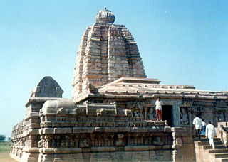
The Shiva temple, Kera, also known as Lakheshwara temple of Kerakot, is located in Kera village near Bhuj of Kutch district in Gujarat, India. The temple was built during the reign of the Chaulukya dynasty (Solankis) in the later part of the 10th Century and is dedicated to Shiva. The temple has been subjected to severe earthquake damage during the earthquake of 1819 and the Bhuj earthquake of 2001. But the temple's spire, inner sanctum and the sculptures are still in an attractive condition.
Majhauli is a Town and a Nagar Panchayat in Sidhi District of Madhya Pradesh. Its also a Tehsil Headquarter.


