
Darwin is the capital city of the Northern Territory, Australia. With a population of 139,902 at the 2021 census, the city contains most of the sparsely populated Northern Territory's residents. It is the smallest, wettest, and most northerly of the Australian capital cities and serves as the Top End's regional centre.

The Litchfield Council is a local government area of the Northern Territory of Australia on the eastern and southeastern outskirts of the Darwin-Palmerston urban area. The municipality covers an area of 2,903 square kilometres (1,120.9 sq mi), and was created by the Northern Territory government on 6 September 1985.

Batchelor is a town in the Northern Territory of Australia. The town is the current seat and largest town of the Coomalie Shire local government area. It is located 98 kilometres (61 mi) south of the territory capital, Darwin. A number of residents commute to Darwin and its suburbs for work.

Hidden Valley is an eastern suburb in the city of Darwin, in the Northern Territory of Australia. It is the traditional country and waterways of the Larrakia people.

Howard Springs is a locality in the Northern Territory. It is 29 kilometres (18 mi) SE of the Darwin CBD. Its local government area is the Litchfield Municipality. The suburb is mostly a rural area, but has been experiencing strong growth in population and development. From 2020, it has housed a major quarantine facility.

Holtze is a locality in Darwin, Northern Territory, Australia. It is 22 km southeast of the Darwin CBD. Its local government area is the Municipality of Litchfield. The locality is mostly a rural area, just north of Palmerston. It was named for Maurice William Holtze (1840–1923), the botanist who established Darwin's Botanical Gardens, and his son Nicholas, who succeeded him as curator.
Virginia is a locality in the Northern Territory of Australia located about 31 kilometres (19 mi) south east of the Darwin CBD. Its Local Government Area is the Litchfield Municipality. The suburb is mostly a rural area, but has been experiencing strong growth in population and development. Settlement of the suburb began in 1869, after George McLachlan surveyed the small satellite town. Virginia has been used as a name for the area since the 1870s.
Berry Springs is a locality in the Northern Territory of Australia. The locality is a mostly rural area situated on the Cox Peninsula Road and is sparsely populated. A few businesses and a school are located in the locality. In the 2016 census, the population of Berry Springs was 818. It is located 58.5 kilometres (36.4 mi) by road from the Darwin Central Business District and lies within the Litchfield Municipality local government area.
Herbert is an outer rural locality of Darwin. It is 44 km South - east of Darwin. Its Local Government Area is the Litchfield Municipality. The suburb is mostly a rural area. It is situated in the vicinity of Benham and Benjamin Lagoons. It was previously considered as part of Humpty Doo.

Noonamah is an outer rural suburban area of Darwin. it is 45 km southeast of the Darwin CBD. Its Local Government Area is the Litchfield Municipality. The suburb is mostly a rural area, but has been experiencing strong growth in population and development. The Elizabeth River flows through Noonamah towards the East Arm of Darwin Harbour.
Koolpinyah is a locality in the Northern Territory of Australia located about 37 kilometres (23 mi) east of the territory capital of Darwin.
Micket Creek is a locality in the Northern Territory of Australia located about 12 kilometres (7.5 mi) east of the territory capital of Darwin.
Glyde Point is a locality in the Northern Territory of Australia located about 37 kilometres (23 mi) north-east of the territory capital of Darwin.
Elrundie is a suburb in the Northern Territory of Australia located in Darwin about 13 kilometres (8.1 mi) east of Darwin City overlooking a part of Darwin Harbour known as the East Arm.
Wishart is a suburb in the Northern Territory of Australia located in Darwin about 10 kilometres (6.2 mi) east of Darwin City.
Tivendale is a suburb in the Northern Territory of Australia located in Darwin about 12 kilometres (7.5 mi) east of Darwin City.
East Arm is a suburb in the Northern Territory of Australia located in Darwin about 8 kilometres (5.0 mi) east of Darwin City overlooking a part of Darwin Harbour known as the East Arm. It is the traditional land and waterways of the Larrakia people.
Wickham is a locality in the Northern Territory of Australia located about 13 kilometres (8.1 mi) south-east of the territory capital of Darwin City and which overlooks Darwin Harbour.
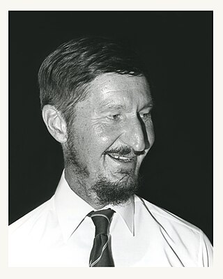
John Hargrave was a renowned Australian surgeon whose work resulted in the near elimination of leprosy in the Northern Territory. In 1959, Hargrave was appointed medical superintendent of the East Arm Leprosarium, which replaced the leper colony known as Channel Island in Darwin Harbour.

The Channel Island Leprosarium was a quarantine station that operated as a colony for people suffering from leprosy in the Northern Territory of Australia from 1931 to 1955. Channel Island forms part of Middle Arm, located just south of Darwin.


