
Tryokhgorny is a closed town in Chelyabinsk Oblast, Russia, located in the western part of the oblast 200 kilometers (120 mi) from Chelyabinsk. Population: 33,670 (2010 Census); 34,290 (2002 Census).

Nagaybaksky District is an administrative and municipal district (raion), one of the twenty-seven in Chelyabinsk Oblast, Russia. It is located in the south of the oblast. The area of the district is 3,022 square kilometers (1,167 sq mi). Its administrative center is the rural locality of Fershampenuaz. Population: 20,927 (2010 Census); 24,310 ; 25,959 (1989 Soviet census). The population of Fershampenuaz accounts for 20.9% of the district's total population.
Miass is a city in Chelyabinsk Oblast, Russia, located 96 kilometers (60 mi) west of Chelyabinsk, on the eastern slope of the Southern Ural Mountains, on the bank of the river Miass. Population: 147,995 (2021 Census); 151,751 (2010 Census); 158,420 (2002 Census); 167,839 (1989 Soviet census).

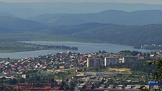
Nyazepetrovsk is a town and the administrative center of Nyazepetrovsky District in Chelyabinsk Oblast, Russia, located on the Nyazya River, 150 kilometers (93 mi) northwest of Chelyabinsk, the administrative center of the oblast. Population: 12,451 (2010 Census); 13,405 (2002 Census); 17,133 (1989 Soviet census).

Korkino is a town and the administrative center of Korkinsky District in Chelyabinsk Oblast, Russia, located on the eastern slope of the Southern Ural Mountains, 42 kilometers (26 mi) south of Chelyabinsk, the administrative center of the oblast. Population: 38,597 (2010 Census); 41,501 (2002 Census); 45,198 (1989 Soviet census).

Sim is a town in Ashinsky District of Chelyabinsk Oblast, Russia. It is located on the Sim River, 340 kilometers (210 mi) west of Chelyabinsk and is the administrative center of the oblast. Population: 14,466 (2010 Census); 16,377 (2002 Census); 20,164 (1989 Soviet census).

Verkhny Ufaley is a town in Chelyabinsk Oblast, Russia, located on the Ufaley River, 142 kilometers (88 mi) northwest of Chelyabinsk, the administrative center of the oblast. Population: 30,481 (2010 Census); 34,360 (2002 Census); 40,061 (1989 Soviet census).

Chebarkulsky District is an administrative and municipal district (raion), one of the twenty-seven in Chelyabinsk Oblast, Russia. It is located in the west of the oblast. The area of the district is 2,879 square kilometers (1,112 sq mi). Its administrative center is the town of Chebarkul. Population: 29,606 (2010 Census); 29,251 ; 34,244 (1989 Soviet census).

Kartalinsky District is an administrative and municipal district (raion), one of the twenty-seven in Chelyabinsk Oblast, Russia. It is located in the southeast of the oblast. The area of the district is 4,737 square kilometers (1,829 sq mi). Its administrative center is the town of Kartaly. Population : 20,256 (2010 Census); 21,961 ; 22,170 (1989 Soviet census).

Kaslinsky District is an administrative and municipal district (raion), one of the twenty-seven in Chelyabinsk Oblast, Russia. It is located in the north of the oblast. The area of the district is 3,356 square kilometers (1,296 sq mi). Its administrative center is the town of Kasli. Population : 17,680 (2010 Census); 14,955 ; 30,627 (1989 Soviet census).

Katav-Ivanovsky District is an administrative and municipal district (raion), one of the twenty-seven in Chelyabinsk Oblast, Russia. It is located in the west of the oblast. The area of the district is 3,415 square kilometers (1,319 sq mi). Its administrative center is the town of Katav-Ivanovsk. Population : 15,327 (2010 Census); 17,739 ; 25,473 (1989 Soviet census).

Krasnoarmeysky District is an administrative and municipal district (raion), one of the twenty-seven in Chelyabinsk Oblast, Russia. It is located in the northeast of the oblast. The area of the district is 3,835 square kilometers (1,481 sq mi). Its administrative center is the rural locality of Miasskoye. Population: 41,710 (2010 Census); 43,553 ; 45,881 (1989 Soviet census). The population of Miasskoye accounts for 23.4% of the district's total population.

Kunashaksky District is an administrative and municipal district (raion), one of the twenty-seven in Chelyabinsk Oblast, Russia. It is located in the northeast of the oblast. The area of the district is 3,280 square kilometers (1,270 sq mi). Its administrative center is the rural locality of Kunashak. Population: 30,112 (2010 Census); 32,225 ; 35,167 (1989 Soviet census). The population of Kunashak accounts for 20.9% of the district's total population.

Nyazepetrovsky District is an administrative and municipal district (raion), one of the twenty-seven in Chelyabinsk Oblast, Russia. It is located in the northwest of the oblast. The area of the district is 3,459 square kilometers (1,336 sq mi). Its administrative center is the town of Nyazepetrovsk. Population: 18,261 (2010 Census); 21,527 ; 27,767 (1989 Soviet census). The population of Nyazepetrovsk accounts for 68.2% of the district's total population.

Satkinsky District is an administrative and municipal district (raion), one of the twenty-seven in Chelyabinsk Oblast, Russia. It is located in the west of the oblast. The area of the district is 2,397 square kilometers (925 sq mi). Its administrative center is the town of Satka. Population : 39,371 (2010 Census); 42,443 ; 46,271 (1989 Soviet census).

Uysky District is an administrative and municipal district (raion), one of the twenty-seven in Chelyabinsk Oblast, Russia. It is located in the west of the oblast. The area of the district is 2,637 square kilometers (1,018 sq mi). Its administrative center is the rural locality of Uyskoye. Population: 26,184 (2010 Census); 28,555 ; 29,132 (1989 Soviet census). The population of Uyskoye accounts for 28.1% of the district's total population.
Varnensky District is an administrative and municipal district (raion), one of the twenty-seven in Chelyabinsk Oblast, Russia. It is located in the southeast of the oblast. The area of the district is 3,853 square kilometers (1,488 sq mi). Its administrative center is the rural locality of Varna. Population: 27,357 (2010 Census); 30,802 ; 30,773 (1989 Soviet census). The population of Varna accounts for 36.1% of the district's total population.

Yetkulsky District is an administrative and municipal district (raion), one of the twenty-seven in Chelyabinsk Oblast, Russia. It is located in the east of the oblast. The area of the district is 2,525 square kilometers (975 sq mi). Its administrative center is the rural locality of Yetkul. Population: 30,697 (2010 Census); 30,165 ; 29,239 (1989 Soviet census). The population of Yetkul accounts for 22.0% of the district's total population.

Kunashak is a rural locality and the administrative center of Kunashaksky District, Chelyabinsk Oblast, Russia. Population: 6,296 (2010 Census); 5,993 (2002 Census); 5,703 (1989 Soviet census).
Kropachyovo is an urban-type settlement in Ashinsky District of Chelyabinsk Oblast, Russia. Population: 5,018 (2010 Census); 5,290 (2002 Census); 5,602 (1989 Soviet census).


