Troitsk is a town in Chelyabinsk Oblast, Russia, located 175 kilometers (109 mi) east of the southern Ural Mountains and approximately 110 kilometers (68 mi) south of Chelyabinsk on the border with Kazakhstan. It stands on the east-flowing Uy River, a branch of the Tobol River. Population: 78,372 (2010 Census); 83,862 ; 90,077 (1989 Soviet census).

Ust-Katav is a town in Chelyabinsk Oblast, Russia, located on the Yuryuzan River. Population: 23,580 (2010 Census); 25,898 (2002 Census); 31,218 (1989 Soviet census).

Yemanzhelinsk is a town and the administrative center of Yemanzhelinsky District in Chelyabinsk Oblast, Russia, located near the border with Kazakhstan on the eastern slopes of the Southern Ural Mountains, 50 kilometers (31 mi) south of Chelyabinsk, the administrative center of the oblast. Population: 30,216 (2010 Census); 30,202 (2002 Census); 31,153 (1989 Soviet census).

Minyar is a town in Ashinsky District of Chelyabinsk Oblast, Russia, located in the valley of the Sim River at its confluence with the Minyar River, 370 kilometers (230 mi) west of Chelyabinsk, the administrative center of the oblast. Population: 10,194 (2010 Census); 11,032 (2002 Census); 12,930 (1989 Soviet census).

Korkino is a town and the administrative center of Korkinsky District in Chelyabinsk Oblast, Russia, located on the eastern slope of the Southern Ural Mountains, 42 kilometers (26 mi) south of Chelyabinsk, the administrative center of the oblast. Population: 38,597 (2010 Census); 41,501 (2002 Census); 45,198 (1989 Soviet census).

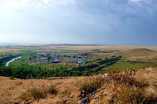
Argayashsky District is an administrative and municipal district (raion), one of the twenty-seven in Chelyabinsk Oblast, Russia. It is located in the north of the oblast. The area of the district is 2,791 square kilometers (1,078 sq mi). Its administrative center is the rural locality of Argayash. Population: 41,387 (2010 Census); 42,808 ; 43,733 (1989 Soviet census). The population of Argayash accounts for 24.3% of the district's total population.

Ashinsky District is an administrative and municipal district (raion), one of the twenty-seven in Chelyabinsk Oblast, Russia. It is located in the west of the oblast. The area of the district is 2,792 square kilometers (1,078 sq mi). Its administrative center is the town of Asha. As of the 2010 Census, the total population of the district was 32,898.
Bredinsky District is an administrative and municipal district (raion), one of the twenty-seven in Chelyabinsk Oblast, Russia. It is located in the south of the oblast. The area of the district is 5,076 square kilometers (1,960 sq mi). Its administrative center is the rural locality of Bredy. Population: 28,498 (2010 Census); 33,039 ; 30,750 (1989 Soviet census). The population of Bredy accounts for 33.2% of the district's total population.

Krasnoarmeysky District is an administrative and municipal district (raion), one of the twenty-seven in Chelyabinsk Oblast, Russia. It is located in the northeast of the oblast. The area of the district is 3,835 square kilometers (1,481 sq mi). Its administrative center is the rural locality of Miasskoye. Population: 41,710 (2010 Census); 43,553 ; 45,881 (1989 Soviet census). The population of Miasskoye accounts for 23.4% of the district's total population.

Kunashaksky District is an administrative and municipal district (raion), one of the twenty-seven in Chelyabinsk Oblast, Russia. It is located in the northeast of the oblast. The area of the district is 3,280 square kilometers (1,270 sq mi). Its administrative center is the rural locality of Kunashak. Population: 30,112 (2010 Census); 32,225 ; 35,167 (1989 Soviet census). The population of Kunashak accounts for 20.9% of the district's total population.

Oktyabrsky District is an administrative and municipal district (raion), one of the twenty-seven in Chelyabinsk Oblast, Russia. It is located in the east of the oblast. The area of the district is 4,356 square kilometers (1,682 sq mi). Its administrative center is the rural locality of Oktyabrskoye. Population: 21,097 (2010 Census); 28,245 ; 30,050 (1989 Soviet census). The population of Oktyabrskoye accounts for 32.1% of the district's total population.

Satkinsky District is an administrative and municipal district (raion), one of the twenty-seven in Chelyabinsk Oblast, Russia. It is located in the west of the oblast. The area of the district is 2,397 square kilometers (925 sq mi). Its administrative center is the town of Satka. Population : 39,371 (2010 Census); 42,443 ; 46,271 (1989 Soviet census).

Troitsky District is an administrative and municipal district (raion), one of the twenty-seven in Chelyabinsk Oblast, Russia. It is located in the central and eastern parts of the oblast. The area of the district is 4,591 square kilometers (1,773 sq mi). Its administrative center is the town of Troitsk. Population: 28,059 (2010 Census); 33,816 ; 34,831 (1989 Soviet census).
Uvelsky District is an administrative and municipal district (raion), one of the twenty-seven in Chelyabinsk Oblast, Russia. It is located in the eastern central part of the oblast. The area of the district is 2,330 square kilometers (900 sq mi). Its administrative center is the rural locality of Uvelsky. Population: 31,867 (2010 Census); 32,188 ; 29,513 (1989 Soviet census). The population of the administrative center accounts for 33.0% of the district's total population.

Uysky District is an administrative and municipal district (raion), one of the twenty-seven in Chelyabinsk Oblast, Russia. It is located in the west of the oblast. The area of the district is 2,637 square kilometers (1,018 sq mi). Its administrative center is the rural locality of Uyskoye. Population: 26,184 (2010 Census); 28,555 ; 29,132 (1989 Soviet census). The population of Uyskoye accounts for 28.1% of the district's total population.

Yetkulsky District is an administrative and municipal district (raion), one of the twenty-seven in Chelyabinsk Oblast, Russia. It is located in the east of the oblast. The area of the district is 2,525 square kilometers (975 sq mi). Its administrative center is the rural locality of Yetkul. Population: 30,697 (2010 Census); 30,165 ; 29,239 (1989 Soviet census). The population of Yetkul accounts for 22.0% of the district's total population.

Chebarkul is a town in Chelyabinsk Oblast, Russia, located on the shores of Lake Chebarkul, 78 kilometers (48 mi) west of Chelyabinsk, the administrative center of the oblast. Population: 42,844 (2010 Census); 47,144 (2002 Census); 50,062 (1989 Soviet census).

Kusa is a town and the administrative center of Kusinsky District in Chelyabinsk Oblast, Russia, located on the Kusa and Ay Rivers, 180 kilometers (110 mi) west of Chelyabinsk, the administrative center of the oblast. Population: 18,792 (2010 Census); 20,316 (2002 Census); 22,606 (1989 Soviet census).
Chesma is a rural locality and the administrative center of Chesmensky District, Chelyabinsk Oblast, Russia. Population: 6,517 (2010 Census); 5,831 (2002 Census); 5,499 (1989 Soviet census).
Oktyabrskoye is a rural locality and the administrative center of Oktyabrsky District, Chelyabinsk Oblast, Russia. Population: 6,780 (2010 Census); 7,562 (2002 Census); 7,975 (1989 Soviet census).