
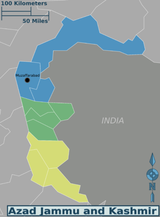
Azad Jammu and Kashmir abbreviated as AJK and colloquially referred to as simply Azad Kashmir, is a region administered by Pakistan as a nominally self-governing entity and constituting the western portion of the larger Kashmir region, which has been the subject of a dispute between India and Pakistan since 1947. Azad Kashmir also shares borders with the Pakistani provinces of Punjab and Khyber Pakhtunkhwa to the south and west, respectively. On its eastern side, Azad Kashmir is separated from the Indian union territory of Jammu and Kashmir by the Line of Control (LoC), which serves as the de facto border between the Indian- and Pakistani-controlled parts of Kashmir. Geographically, it covers a total area of 13,297 km2 (5,134 sq mi) and has a total population of 4,045,366 as per the 2017 national census.

Gilgit is a city in Pakistani-administered Gilgit–Baltistan in the disputed Kashmir region. It is the capital of the Gilgit-Baltistan region. The city is located in a broad valley near the confluence of the Gilgit and the Hunza rivers. It is a major tourist destination in Pakistan, serving as a hub for trekking and mountaineering expeditions in the Karakoram mountain range.

Skardu is a city located in Pakistan-administered Gilgit-Baltistan in the disputed Kashmir region. Skardu serves as the capital of Skardu District and the Baltistan Division. It is situated at an average elevation of nearly 2,500 metres above sea level in the Skardu Valley, at the confluence of the Indus and Shigar rivers. The city is an important gateway to the eight-thousanders of the nearby Karakoram mountain range. The Indus River running through the region separates the Karakoram from the Ladakh Range.

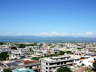
Muzaffarabad is a city in Pakistani-administered Azad Kashmir in the disputed Kashmir region. It is the largest city and the capital of Azad Kashmir, which is a Pakistani-administered administrative territory.

Baramulla district or Varmul is one of the 20 districts in the Indian-administered union territory of Jammu and Kashmir in the disputed Kashmir region. Baramulla town is the administrative headquarters of this district. The district covered an area of 4,588 km2 (1,771 sq mi) in 2001, but it was reduced to 4,243 km2 (1,638 sq mi) at the time of 2011 census. In 2016, the district administration said that the area was 4,190 km2 (1,620 sq mi). Muslims constitute about 98% of the population.
Mirpur, officially known as New Mirpur City, is the capital of Mirpur district located in Azad Kashmir, Pakistan which has been subject of the larger Kashmir dispute between Pakistan and India since 1947. It is the second largest city of Azad Kashmir and the 74th largest city in Pakistan.

Uri is a town and a tehsil in the Baramulla district, in the Indian union territory of Jammu and Kashmir. Uri is located on the left bank of the Jhelum River, about 10 kilometres (6.2 mi) east of the Line of Control with Pakistan.

Rawalakot is the capital of Poonch district in Azad Kashmir, Pakistan. It is located in the Pir Panjal Range.
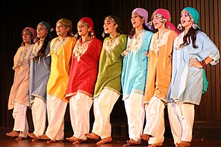
Kashmiris are an Indo-Aryan ethnolinguistic group speaking the Kashmiri language and originating from the Kashmir Valley, which is today located in Indian-administered Jammu and Kashmir.

Rajouri is a district in the Jammu division of Indian-administered Jammu and Kashmir in the disputed Kashmir region. The Line of Control, between the Indian- and Pakistani-administered Jammu and Kashmir, lies to its west, Poonch to its north, the Reasi district to the east and the Jammu district to its south. Rajouri is famous for its "Kalari". Representing an ancient principality, Rajouri was a joint district, along with Reasi, at the time of princely state's accession to India in 1947. The two tehsils were separated and Rajouri was merged with the Poonch district. Rajouri again became a separate district along with Reasi in 1968 till 2006 when both were separated again. The Rajouri district comprises 13 tehsils (boroughs). The land is mostly fertile and mountainous. Maize, wheat and rice are the main crops of the area and the main source of the irrigation is the river Tawi that originates from the mountains of Pir Panjal.
The Bomba, also spelled Bambas, are a Rajput tribe found in the Pakistani-controlled territory of Azad Jammu and Kashmir and the Indian Union territory of Jammu and Kashmir. In Azad Kashmir, they are primarily found in Muzaffarabad and Neelum districts, with a large number concentrated in and around the town of Ghori. Outside of Azad Kashmir, they are also found in the Boi and Kaghan valleys of Mansehra District, and the city of Abbottabad, all located in Khyber Pakhtunkhwa. In Jammu and Kashmir, they are found in the Poonch and Rajouri districts of Jammu division.

Poonch District was a district of the princely state of Jammu and Kashmir, which is currently divided between India and Pakistan. The Pakistani part of the erstwhile district is now the Poonch Division in the Azad Kashmir territory, whilst the Indian part of the district is the Poonch district in Jammu and Kashmir. The capital of the Pakistan-controlled side is Rawalakot; while the capital of the Indian-controlled side is Poonch.
The Azad Kashmir Regiment is one of six infantry regiments in the Pakistan Army named after Azad Kashmir. It holds the distinction of being the only Battle Born Regiment in South Asia, formed by locals of Azad Kashmir to fight against Dogra Raj and it is the first regiment raised after Pakistan's independence. With the Regimental Centre at Mansar Mansar Camp in Attock District, the Regiment has gallantly participated in all Operations and Wars fought by the Pakistan Army

Raja Muhammad Farooq Haider Khan is an Azad Kashmiri politician and former Prime Minister of Azad Jammu and Kashmir. He is a senior member of the Pakistan Muslim League (N).

Hattian Bala District is a district of Pakistan-administered Azad Kashmir in the disputed Kashmir region. The town of Hattian Bala is where the district headquarters are located. The Hattian Bala District was a part of the Muzaffarabad District until 2009 when it was made a separate district.

The history of Azad Kashmir, a disputed part of the Kashmir region currently administered by Pakistan, is related to the history of the Kashmir region during the Dogra rule. Azad Kashmir borders the Pakistani provinces of Punjab and Khyber Pakhtunkhwa to the south and west respectively, Gilgit–Baltistan to the north, and the Indian union territory of Jammu and Kashmir to the east. The region is claimed by India and has been the subject of a dispute between India and Pakistan since 1947.
The Azad Kashmir Regular Force (AKRF), formerly known as the Kashmir Liberation Forces(KLF), were the irregular forces of Azad Kashmir until 1948. They then were taken over by the government of Pakistan and converted into a regular force. In this form, the unit became part of the country's paramilitary forces, operating out of the nominally self-governing territory of Azad Jammu and Kashmir. The AKRF was altered from a functioning paramilitary force and merged into the Pakistan Army as an infantry regiment following the Indo-Pakistani War of 1971.
In spring 1947, an uprising against the Maharaja Hari Singh of Jammu and Kashmir broke out in the Poonch jagir, an area bordering the Rawalpindi district of West Punjab and the Hazara district of the North-West Frontier Province in the future Pakistan. It was driven by grievances such as high taxes, the Maharaja's neglect of World War veterans, and above all, Muslim nationalism with a desire to join Pakistan. The leader of the rebellion, Sardar Muhammad Ibrahim Khan, escaped to Lahore by the end of August 1947 and persuaded the Pakistani authorities to back the rebellion. In addition to the backing, Prime Minister Liaquat Ali Khan authorised an invasion of the state, by the ex-Indian National Army personnel in the south and a force led by Major Khurshid Anwar in the north. These invasions eventually led to the First Kashmir War fought between India and Pakistan, and the formation of Azad Kashmir provisional government. The Poonch jagir has since been divided across Azad Kashmir, administered by Pakistan and the state of Jammu and Kashmir, administered by India.
The High Court of Azad Jammu and Kashmir is an appellate court in Muzaffarabad, Azad Jammu and Kashmir. It hears appeals from the District Courts of Azad Kashmir. The court has three circuit benches based in Kotli, Mirpur, and Rawalakot.

Kashmiris in Azad Kashmir are the ethnic Kashmiri people who reside in Azad Kashmir, a territory which constitutes part of Pakistani-administered Kashmir since the end of the First Kashmir War. Their demographic includes up to 40,000 registered Kashmiri refugees who have fled the Kashmir Valley, located in Indian-administered Kashmir, to Pakistan since the late 1980s due to conflict in the region. As of 2010, only around 60 percent of Kashmiri refugees had acquired Pakistani citizenship.

