
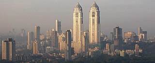
Pune, previously known as Poona, is a city in Maharashtra state in Deccan plateau in Western India. It is the administrative headquarters of the Pune district, and of Pune division. The city of Pune is part of Pune Metropolitan Region. Pune is one of the largest IT hubs in India. It is also one of the most important automobile and manufacturing hubs of India. Pune is often referred to as "Oxford of the East" because of highly regarded educational institutions in the city. It has been ranked "the most liveable city in India" several times.

Pimpri-Chinchwad, also known as PCMC, is a city in the Indian state of Maharashtra. The city is about 15 km (9.3 mi) northwest of the historic city of Pune, at an altitude of 590 m (1,940 ft) above sea level. It is the fifth largest city in Maharashtra and the nineteenth largest city in India and the sixteenth largest satellite city in the world by population. The city is located 135 km (84 mi) southeast from the state's capital Mumbai. It is one of the most rapidly developing suburban areas in India and has emerged as the third fastest growing city in the country. It is well known for its automotive, IT and manufacturing industry.

Pune district is a district in Western Maharashtra with Administrative Headquarter in Pune city. Pune district is the most populous district in the Indian state of Maharashtra. It is one of the most industrialised districts in India.

Pune Airport is an international airport and an Indian Air Force base serving the city of Pune, Maharashtra, India. It is located at Lohegaon, approximately 11 km (6.8 mi) northeast of the historic centre of Pune. The airport is a civil enclave operated by the Airports Authority of India at the western side of Lohegaon Air Force Station of the Indian Air Force. The airport is the tenth busiest airport by passenger traffic in India. The airport serves both domestic and international flights. In financial year 2020, the airport handled over 8 million passengers.
Chakan is a census town in India, in Pune district of the Indian state of Maharashtra. While agriculture remains an important factor, the town's industrial development is quickly urbanizing the area.
The economy of the state of Maharashtra is the largest in India. It is one of the most urbanised of Indian States.
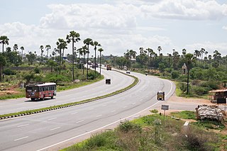
National Highway 65, , is a National Highway in India. It runs along the states of Maharashtra, Karnataka, Telangana and Andhra Pradesh. It starts at Pune and ends at Machilipatnam. Major cities on this route are Pune, Solapur, Hyderabad, Suryapet, Vijayawada and Machilipatnam. The section between Hyderabad and Vijayawada, is known as Vijayawada–Hyderabad Expressway and is a major expressway.
Kolad is a village in Raigad district, Maharashtra State, India. It is 117 km from Mumbai on the National Highway no 66(Mumbai-Goa) its also connected Pune via kolad Pune- kolad state highaway. It lies on the banks of River Kundalika. The village post office Postal Index Number is 402304 & 402109.

Maharashtra Cricket Association Stadium is a cricket stadium situated in Pune, Maharashtra, India. It is owned and operated by Maharashtra Cricket Association. It is located beside the Pune - Mumbai expressway in Pune district.

The Maharashtra Cricket Association is the governing body of the cricket in the Maharashtra state of India. Its Maharashtra cricket team represent Maharashtra state in Indian cricket. It is affiliated to the Board of Control for Cricket in India.

Katraj is suburb of Pune in the Indian state of Maharashtra, and within the jurisdiction of Pune Municipal Corporation. Katraj is famous for its Peshwa-era lake that supplied water to the city during that period. The village lies at the foot of the Katraj Ghat or mountain pass on the main National Highway 4 connecting Pune with places south of the city, such as Kolhapur and Bangalore. In recent decades area surrounding the lake and the village of Katraj became part the City of Pune. The former rural area is now surrounded by residential complexes. The lakeside hosts the Rajiv Gandhi Zoological Park. Bharati Vidyapeeth, a deemed university, has its main campus here. A large Jain temple was built here in late 20th century.
Pune Metropolitan Region (PMR) is the metropolitan region around the city of Pune. According to practical purposes, PMR comprises two Municipal Corporations of PMC, PCMC and three Cantonment Boards, spread over an area of 7,256.46 km2. The population of the region as per 2011 census was 7,541,946.
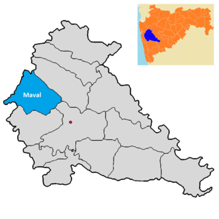
Maval taluka is a taluka in Mawal subdivision of Pune district of state of Maharashtra in India.

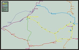
Pune Ring Road is a road planned for construction in and around the city of Pune, India. Pune Metropolitan Region Development Authority claimed that the road will decrease traffic congestion and provide better access to the fastest growing areas. The road will be 173 km long and will service twenty-nine villages by connecting all highways around the city. The cost is estimated at ₹104.08 billion (US$1.3 billion).
Koregaon Bhima is a panchayat village and census town in the state of Maharashtra, India, on the left (north) bank of the Bhima River. Administratively, Koregaon Bhima is under Shirur Taluka of Pune District in Maharashtra. There is only the single town of Koregaon Bhima in the Koregaon Bhima gram panchayat. The town of Koregaon Bhima is 10 km along the SH 60 motorway southwest of the village of Shikrapur, and 28 km by road northeast of the city of Pune. It is the site of the Battle of Koregaon fought on 1 January 1818.
Pune is a city in the state of Maharashtra in India. It is situated in western Maharashtra on the Deccan Plateau. Pune's public transport consists primarily of a bus service, a suburban rail service, metro, public taxis and auto rickshaws. In 2020 it was awarded the Sustainable Transport Award.
Chhatrapati Sambhaji Raje International Airport is a proposed greenfield airport project to serve the city of Pune, India. It will be built near Saswad and Jejuri in Purandar taluka of Pune District in the Indian state of Maharashtra. In 2016, it was announced that the proposed airport would be spread over 2,400 hectares. The airport would be named after the King of the Maratha Empire, Sambhaji Maharaj, who was born at Purandar fort.
Sangavi is a village in India, situated in the Baramati taluka on the river of nira of Pune district in the state of Maharashtra. It encompasses an area of 400.03 ha.
Mangdari is a village in Velhe Taluka in the Pune District of Maharashtra, India.
Jambhali is a village in the Bhor taluka in the Pune District of Maharashtra, India.