Choteau Mountain is located along the Rocky Mountain Front, which is a subset of the Rocky Mountains. It is situated 26 miles northwest of the town of Choteau, in the Lewis and Clark National Forest. Precipitation runoff from the mountain drains into tributaries of the Teton River. Topographic relief is significant as the southwest aspect rises 3,200 feet (980 meters) above the river in two miles, and the east aspect rises 3,700 feet (1,100 meters) above the prairie.
Geology
Choteau Mountain is composed of sedimentary rock laid down during the Precambrian to Jurassic periods. Formed in shallow seas, this sedimentary rock was pushed east and over the top of younger rock during the Laramide orogeny.[4] The Lewis Overthrust extends over 280 miles (450km) from Mount Kidd in Alberta, south to Steamboat Mountain which is located 46 miles south of Choteau Mountain, which places Choteau Mountain within the southern part of the Lewis Overthrust.[5]
Climate
Based on the Köppen climate classification, Choteau Mountain is located in a subarctic climate zone characterized by long, usually very cold winters, and mild to warm summers.[6] Winter temperatures can drop below −10°F with wind chill factors below −30°F.
Gallery
Aerial view of Choteau Mountain centered on horizon, with Guthrie Peak (right)
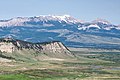
Choteau Mountain (left), with parent Guthrie Peak (right)
↑Gadd, Ben (2008). "Geology of the Rocky Mountains and Columbias".{{cite journal}}: Cite journal requires |journal= (help)
↑Feinstein, Shimon; Kohn, Barry; Osadetz, Kirk; Price, Raymond A. (January 1, 2007). "Thermochronometric reconstruction of the prethrust paleogeothermal gradient and initial thickness of the Lewis thrust sheet, southeastern Canadian Cordillera foreland belt". Geological Society of America Special Papers. 433: 167–182. doi:10.1130/2007.2433(08). ISBN978-0-8137-2433-1. ISSN0072-1077.
This page is based on this Wikipedia article Text is available under the CC BY-SA 4.0 license; additional terms may apply. Images, videos and audio are available under their respective licenses.