Christiana, South Africa

Last updated
Christiana
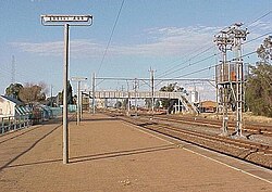
Station Christiana 1.JPG
Christiana railway station
South Africa North West location map.svg
Red pog.svg
Christiana
South Africa adm location map.svg
Red pog.svg
Christiana
Coordinates: 27°55′12″S25°9′36″E / 27.92000°S 25.16000°E / -27.92000; 25.16000
Country South Africa
Province North West
District Dr Ruth Segomotsi Mompati
Municipality Lekwa-Teemane
Established1870 [1]
Area
[2]
  Total50.20 km2 (19.38 sq mi)
Population
 (2011) [2]
  Total3,571
  Density71/km2 (180/sq mi)
Racial makeup (2011)
[2]
   Black African 16.6%
   Coloured 3.3%
   Indian/Asian 1.1%
   White 77.6%
  Other1.5%
First languages (2011)
[2]
   Afrikaans 84.9%
   Tswana 7.2%
   English 4.4%
   Sotho 1.2%
  Other2.4%
Time zone UTC+2 (SAST)
Postal code (street)
2680
PO box
2680
Area code 053

Christiana is an agricultural town of about 3,000 inhabitants on the banks of the Vaal River in North West province, South Africa. The town is located on the N12 national route between Bloemhof and Warrenton, on the way to Kimberley (Northern Cape). It is the administrative centre and seat of Lekwa-Teemane Local Municipality. [3]

Contents

History

When diamonds were discovered in the Vaal River in the 1870's Transvaal Government established a settlement on the banks of the river in 1870, in an attempt to control and alleviate land disputes over diamond discoveries further down the Vaal River. This town was established on the farm Zoutpansdrift ("salt pan drift") and named Christiana, after the only daughter of President Pretorius of the old Transvaal. The first residential stands were sold in 1870.

Two years later diamonds were discovered close by in the gravel bed of the Vaal River, and the inevitable manic rush followed. As usual, the initial rush petered with the diamonds. In 1997, diamonds were rediscovered along the banks of a farm on the Free State side of Christiana. This led to a new diamond rush and diggings that continue to this day.

Economy

The town contains one of the biggest diggers' bells ever to exist in the world. The bell is currently underwater in the Vaal River as it once sank and ended in the drowning of several diggers. There were a few attempts to get the diggers' bell out, as it is said that there are diamonds still in it, but it was in vain as it is surrounded by too much mud.

Christiana is one of the corners of the "Maize Rectangle", with the mainstay of the economy being the production of maize, potatoes, onions, sorghum, groundnuts and beef. The main farmers in the area are the de Beer's and Callender-Easby's. South Africa's top horse stud, Callaho Warmblood Sport Horses, can be found near Christiana.

Christiana is well known for its water sports along the Vaal River, as well as the Diamond Diggers Festival (Delwers Fees) that occurs annually. Other tourist attractions include the Diggers' Diamond Museum (authentic digging equipment and old photographs pay tribute to the town's diamond industry) and San Bushman rock art (excellent examples can be viewed 6 km out of town on the Farm Stowlands) and Stows Kopje (prehistoric rock engravings which are a provincial heritage site).

Related Research Articles

<span class="mw-page-title-main">Orange Free State</span> 1854–1902 Boer republic in Southern Africa

The Orange Free State was an independent Boer sovereign republic under British suzerainty in Southern Africa during the second half of the 19th century, which ceased to exist after it was defeated and surrendered to the British Empire at the end of the Second Boer War in 1902. It is one of the three historical precursors to the present-day Free State province.

<span class="mw-page-title-main">Orange River</span> Major river in southern Africa

The Orange River is a river in Southern Africa. It is the longest river in South Africa. With a total length of 2,432 km (1,511 mi), the Orange River Basin extends from Lesotho into South Africa and Namibia to the north. It rises in the Drakensberg mountains in Lesotho, flowing westwards through South Africa to the Atlantic Ocean. The river forms part of the international borders between South Africa and Lesotho and between South Africa and Namibia, as well as several provincial borders within South Africa. Except for Upington, it does not pass through any major cities. The Orange River plays an important role in the South African economy by providing water for irrigation and hydroelectric power. The river was named the Orange River in honour of the Dutch ruling family, the House of Orange, by the Dutch explorer Robert Jacob Gordon. Other names include simply the word for river, in Khoekhoegowab orthography written as !Garib, which is rendered in Afrikaans as Gariep River with the intrusion of a velar fricative in place of the alveolar click, Groote River or Senqu River, derived from ǂNū "Black". It is known in isiZulu as isAngqu.

<span class="mw-page-title-main">Vaal River</span> Tributary of the Orange River, South Africa

The Vaal River is the largest tributary of the Orange River in South Africa. The river has its source near Breyten in Mpumalanga province, east of Johannesburg and about 30 kilometres (19 mi) north of Ermelo and only about 240 kilometres (150 mi) from the Indian Ocean. It then flows westwards to its confluence with the Orange River southwest of Kimberley in the Northern Cape. It is 1,458 kilometres (906 mi) long, and forms the border between Mpumalanga, Gauteng and North West Province on its north bank, and the Free State on its south.

<span class="mw-page-title-main">Transvaal (province)</span> Former province of South Africa

The Province of the Transvaal, commonly referred to as the Transvaal, was a province of South Africa from 1910 until 1994, when a new constitution subdivided it following the end of apartheid. The name "Transvaal" refers to the province's geographical location to the north of the Vaal River. Its capital was Pretoria, which was also the country's executive capital.

<span class="mw-page-title-main">Boer republics</span> Former countries in southern Africa

The Boer republics were independent, self-governing republics formed by Dutch-speaking inhabitants of the Cape Colony and their descendants. The founders – variously named Trekboers, Boers and Voortrekkers – settled mainly in the middle, northern, north-eastern and eastern parts of present-day South Africa. Two of the Boer Republics achieved international recognition and complete independence: the South African Republic and the Orange Free State. The republics did not provide for the separation of church and state, initially allowing only the Dutch Reformed Church, and later also other Protestant churches in the Calvinist tradition. The republics came to an end after the Second Boer War of 1899–1902, which resulted in British annexation and later incorporation of their lands into the Union of South Africa.

<span class="mw-page-title-main">Griqualand West</span> Area of central South Africa

Griqualand West is an area of central South Africa with an area of 40,000 km2 that now forms part of the Northern Cape Province. It was inhabited by the Griqua people – a semi-nomadic, Afrikaans-speaking nation of mixed-race origin, who established several states outside the expanding frontier of the Cape Colony. It was also inhabited by the pre-existing Tswana and Khoisan peoples.

<span class="mw-page-title-main">Vereeniging</span> City in Gauteng, South Africa

Vereeniging is a city located in the south of Gauteng province, South Africa, situated where the Klip River empties into the northern loop of the Vaal River. It is also one of the constituent parts of the Vaal Triangle region and was formerly situated in the Transvaal province. The name Vereeniging is the Dutch word meaning "association".

<span class="mw-page-title-main">Bothaville</span> Place in Free State, South Africa

Bothaville is a maize farming town situated near the Vaal River in the Lejweleputswa DM of the Free State province, South Africa. It is situated 60 km east of the Vaal, on the bank of its Vals River tributary. Bothaville and the adjacent Kgotsong township have a total of approximately 46,000 residents.

Jacobsdal is a small farming town in the Free State province of South Africa with various crops under irrigation, such as grapes, potatoes, lucerne, and groundnuts. The town was laid out in 1859 by Christoffel Jacobs on his farm Kalkfontein, and its last recorded population was 3,504.

Villiers is a small town situated on the banks of the Vaal River next to the N3 highway in the Free State province of South Africa. It was founded in 1882 on the two farms Pearson Valley and Grootdraai owned by Lourens de Villiers.

<span class="mw-page-title-main">Vredefort</span> Place in Free State, South Africa

Vredefort is a small farming town in the Free State province of South Africa with cattle, peanuts, sorghum, sunflowers and maize being farmed. It is home to 3,000 residents.

Lichtenburg is a town situated in North West Province, South Africa. It is the administrative centre of Ditsobotla Local Municipality.

<span class="mw-page-title-main">Barkly West</span> Place in Northern Cape, South Africa

Barkly West is a town in the Northern Cape province of South Africa, situated on the north bank of the Vaal River west of Kimberley.

<span class="mw-page-title-main">Warrenton, South Africa</span> Place in Northern Cape, South Africa

Warrenton is an agricultural town of approximately 22,588 people in the Northern Cape province of South Africa, situated 70 kilometres (40 mi) north of Kimberley on the Vaal River.

Windsorton is an agricultural town situated in the Vaalharts Irrigation Scheme on the banks of the Vaal River in the Northern Cape province of South Africa.

<span class="mw-page-title-main">South African Wars (1879–1915)</span> Series of conflicts

The South African Wars, including – and commonly referred to as – the Confederation Wars, were a series of wars that occurred in the southern portion of the African continent between 1879 and 1915. Ethnic, political, and social tensions between European colonial powers and indigenous Africans led to increasing hostilities, culminating in a series of wars and revolts, which had lasting repercussions on the entire region. A key factor behind the growth of these tensions was the pursuit of commerce and resources, both by countries and individuals, especially following the discoveries of diamonds in the region in 1867 and gold in 1862.

<span class="mw-page-title-main">Nooitgedacht Glacial Pavements</span>

The Nooitgedacht Glacial Pavements comprise a geological feature between Kimberley and Barkly West, South Africa, pertaining to the Palaeozoic-age Dwyka Ice Age, or Karoo Ice Age, where the glacially scoured ancient bedrock was used, substantially more recently, during the Later Stone Age period in the late Holocene as panels for rock engravings.

<span class="mw-page-title-main">Canteen Kopje</span>

Canteen Kopje is an archaeological site, formally protected as a grade 2 provincial heritage site, and approved in 2017 for re-grading to national status, situated outside Barkly West in the Northern Cape, South Africa. The place was previously known as Klipdrift, meaning stony drift, a translation from a still earlier !Ora name, !a |aub. Canteen Kopje is best known for its long and exceptionally rich Earlier Stone Age sequence, spanning circa >0.5 to 1.7 million years, occurring within gravels exposed in late nineteenth/early twentieth century mining pits. Also attracting attention are more recent archaeological levels in the overlying Hutton Sands, which contain material known as Fauresmith, Middle Stone Age, Later Stone Age, and late Iron Age with evidence of protocolonial/colonial contact and interaction, probably, with nineteenth century diamond diggers.

Delportshoop is a town in Frances Baard District Municipality in the Northern Cape Province of South Africa. It lies next to the Vaal River. The Harts River runs by closely.

Johannes Petrus Meyer was a politician, member of the Volksraad of the South African Republic, mining entrepreneur, and farmer; he is the man for whom Meyerton and Meyersdal are named.

References

  1. Robson, Linda Gillian (2011). "Annexure A" (PDF). The Royal Engineers and settlement planning in the Cape Colony 1806–1872: Approach, methodology and impact (PhD thesis). University of Pretoria. pp. xlv–lii. hdl:2263/26503.
  2. 1 2 3 4 "Main Place Christiana". Census 2011.
  3. Municipal Demarcation Board : Municipal Profiles 2003 : Contacts Archived 2008-10-07 at the Wayback Machine Retrieved 15 April 2010