
Newport is a suburb of the town of Launceston in Cornwall, England, United Kingdom. Originally a separate settlement, Newport is immediately north of the town from which it is separated by the River Kensey.
St Clether is a civil parish and village in Cornwall, England, United Kingdom. The village is situated on the east flank of Bodmin Moor approximately eight miles (13 km) west of Launceston in the valley of the River Inny. The population of the civil parish at the 2011 census was 156.

Polyphant, recorded as Polefant c. 1170, is a village in east Cornwall, England, United Kingdom. It is north of the civil parish of Lewannick, five miles (8 km) west of the town of Launceston near the convergence of the River Inny and Penpont Water.
Polyne Quarry is a 0.1 hectare Site of Special Scientific Interest (SSSI) in Cornwall, England, UK. It is located to the north of Polperro civil parish, 2 miles (3.2 km) to the west of Looe.

Penwithick or Penwithick Stents is a village in Cornwall, England, United Kingdom. It is situated 2.5 miles (4.0 km) north of St Austell, in the civil parish of Treverbyn in the 'clay country' area of china clay quarrying. Whilst falling in a different civil parish Penwithick does have an electoral ward in its own name. The population of the ward at the census 2011 was 4,479
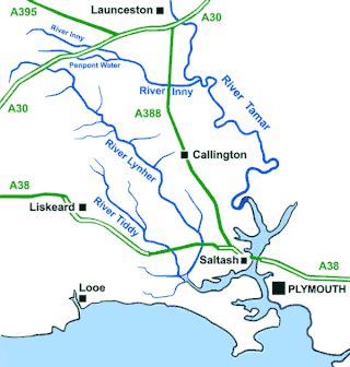
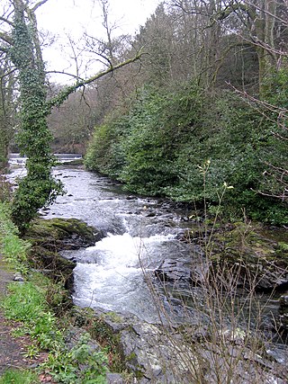
The River Inny is a small river in East Cornwall, England, United Kingdom. A tributary of the River Tamar, the Inny is about twenty miles (32 km) long from its source near Davidstow on the eastern flank of Bodmin Moor to its confluence with the Tamar at Inny Foot near Dunterton.

The A374 is a main road in the United Kingdom, one of six A-roads making the border crossing between Devon and Cornwall. It is the most southerly of the A37x group of roads, starting and ending its journey with the A38 trunk road, from the outskirts of Plymouth in Devon to the Trerulefoot roundabout in Cornwall.

Two Bridges is a settlement in east Cornwall, England, United Kingdom, 4 miles (6 km) west-southwest of Launceston at the point where the A30 trunk road crosses the River Inny. The Inny's main tributary, Penpont Water, joins it at Two Bridges.

Congdon's Shop is a hamlet in the parish of North Hill, Cornwall, England. It is at the junction of the B3254 Launceston to Liskeard road and the B3257 road from Plusha to Callington.

Hellandbridge is a hamlet in Cornwall, England, UK. It is about a mile west-northwest of the village of Helland on the River Camel and next to the railway line to Wenford Bridge.

Old Mill is a hamlet in the civil parish of Stokeclimsland, Cornwall, England.
Looe Mills or Looemills is a hamlet in Cornwall, England. It is on the A38 road between Liskeard and Dobwalls. According to the Post Office the population at the 2011 census was included in the civil parish of Dobwalls and Trewidland.
Middlehill is a hamlet in the parish of St Ive and Pensilva, Cornwall, England.
Muchlarnick is a hamlet in Cornwall, England. It is about two miles east of Lanreath in the civil parish of Pelynt.
Redmoor is a hamlet in Cornwall, England, United Kingdom.

Rilla Mill is a small settlement in Cornwall, England, part of the civil parish of Linkinhorne, some 1+1⁄2 miles to the west of Linkinhorne village.
Penpont Water is a small river in east Cornwall, England, United Kingdom. It is the main tributary of the River Inny, joining it at Two Bridges.

The River Kensey is a river in east Cornwall, England, UK which is a tributary of the River Tamar.
The River Seaton is a river in east Cornwall, England, UK which flows southwards for 11 miles (17 km) into the English Channel.

The River Lerryn is a river in east Cornwall, England, UK, a tributary of the River Fowey. The Lerryn is the largest of the tributaries which enter the estuary of the Fowey. The river is tidal up to the village of Lerryn. The landscape of the Lerryn catchment is rural and includes heathland, moorland and rough pasture in the upper reaches and broadleaf, coniferous and mixed plantation woodland in the lower. This catchment includes four SSSIs, including Redlake Meadows & Hoggs Moor. The Lerryn rises at Fairy Cross on the southern slopes of Bodmin Moor and flows south-southwest until it enters the Fowey estuary.
