Chycoose

Last updated

Penpol Creek, an inlet on the north bank of Restronguet Creek Penpoll Creek - geograph.org.uk - 148662.jpg
Penpol Creek, an inlet on the north bank of Restronguet Creek
Houses on the shore at Point near Chycoose Waterside Cottages on Restronguet Creek - geograph.org.uk - 148652.jpg
Houses on the shore at Point near Chycoose

Chycoose (Cornish : Chy'n Coos, meaning house of the wood), Point and Penpol (Cornish : Pen Pol, meaning head of a creek) form a coastal settlement around Penpol Creek in Cornwall, England, United Kingdom.

The creek is a ria, a tidal inlet on the north side of Restronguet Creek. It is situated approximately three-quarters of a mile (1 km) west of Feock village which is four miles (6.5 km) south of Truro. [1]

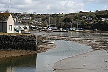
Chycoose is on the west bank of Penpol Creek and Penpol hamlet is at the north end of the creek. Point is on a small promontory where Penpol Creek joins Restronguet Creek.

Trolver, a small coastal settlement, extends along the east side of the Penpol Creek south from Penpol.

Today, all four settlements are residential in character with many of the houses having river frontages and all four are in the civil parish of Feock. [2]

However, until the beginning of the 20th century, Restronguet Creek was a busy commercial waterway with extensive wharves on the north bank. Penpol was a small port engaged in the export of tin and copper from the mining areas a few miles to the north and there were wharves at Point Quay served by an extension of the Redruth and Chasewater Railway; trains on this section of line were hauled by horses from Devoran, a mile (1.6 km) upstream.

Restronguet Creek and Carrick Roads (the tidal estuary of the River Fal) are a popular centre for yachting and dinghy racing and the quay at Penpol is now used for leisure boating.

'The Restronguet Creek Society' is a voluntary organisation formed in 1972 to protect and preserve the creek and its environs. [3]

Related Research Articles

River Fal River in Cornwall, England

The River Fal flows through Cornwall, England, rising at Pentevale on Goss Moor and reaching the English Channel at Falmouth. On or near the banks of the Fal are the castles of Pendennis and St Mawes as well as Trelissick Garden. The River Fal separates the Roseland peninsula from the rest of Cornwall. Like most of its kind on the south coast of Cornwall and Devon, the Fal estuary is a classic ria, or drowned river valley. The Fal estuary from Tregony to the Truro River was originally called Hafaraell.

Truro River River in Cornwall, England

The Truro River is a river in the city of Truro in Cornwall, England, UK. It is the product of the convergence of the two rivers named Kenwyn and Allen which run under the city: the Truro River flows into the River Fal, estuarial waters where wildlife is abundant, and then out into the Carrick Roads. The river is navigable up to Truro.

Helford River Ria in Cornwall, England

The Helford River is a ria in Cornwall, England, fed by small streams into its many creeks. There are seven creeks on the Helford; from west to east these are Ponsontuel Creek, Mawgan Creek, Polpenwith Creek, Polwheveral Creek, Frenchman's Creek, Port Navas Creek, and Gillan Creek. The best known of these is Frenchman's Creek, made famous by Daphne du Maurier in her novel of the same name. A little further up river is Tremayne Quay, built for a visit by Queen Victoria in the 1840s which she then declined to make, allegedly because it was raining.

Carrick Roads Estuary of the River Fal in Cornwall, England

Carrick Roads is the estuary of the River Fal on the south coast of Cornwall in England. It joins the English Channel at its southern end near Falmouth.

Perranarworthal Village in Cornwall, England

Perranarworthal is a civil parish and village in Cornwall, England, United Kingdom. The village is about four miles (6.5 km) northwest of Falmouth and five miles (8 km) southwest of Truro. Perranarworthal parish is bordered on the north by Kea parish, on the east by Restronguet Creek and Mylor parish, on the south by St Gluvias and Stithians parishes and on the west by Gwennap parish. The parish population at the 2011 census was 1,496. The name derives from the Manor of Arworthal which has had a number of spellings in the past including Hareworthal (1187), Arwoethel and Arwythel. By the 18th-century two names appear on maps "Perran Arworthal" meaning St Piran's by the creek or estuary. William Penaluna described the settlement in 1838. Perranwell railway station is on the Maritime Line.

Feock is a coastal civil parish and village in Cornwall, England, United Kingdom. It is about 5 miles (8.0 km) south of Truro at the head of Carrick Roads on the River Fal. To the south, the parish is bordered by Restronguet Creek and to the east by Carrick Roads and the River Fal. To the north it is bordered by Kea parish and to the west by Perranarworthal parish.

Mylor, Cornwall Civil parish in Cornwall, England

Mylor is a civil parish in Cornwall, England, United Kingdom. It is situated approximately five miles north of Falmouth.

Kea, Cornwall Human settlement in England

Kea is a civil parish and village in Cornwall, England, United Kingdom. It is a "large straggling parish" in a former mining area south of Truro.

St Just in Roseland Village and civil parish in Cornwall, England

St Just in Roseland is a village and civil parish in Cornwall, England, United Kingdom. The village is 6 miles (10 km) south of Truro and 2 miles (3 km) north of St Mawes, a small village within the parish of St Just in Roseland. The 2011 Census recorded the parish population as 1,158.

The Redruth and Chasewater Railway,, was an early mineral railway line in Cornwall, England, UK. It opened in 1825 and was built to convey the output from copper mines in the Gwennap area to wharves on Restronguet Creek around Devoran, and to bring in coal to fuel mine engines; later it carried timber for pit props and also house coal.

Devoran Village in south Cornwall, England

Devoran is a village in south Cornwall, England, United Kingdom. It is 4 miles (6.4 km) southwest of Truro at grid reference SW 793 392. Formerly an ecclesiastical parish, Devoran is now in the civil parish of Feock.

Great County Adit Series of interconnected drainage adits in Cornwall, England

The Great County Adit, sometimes called the County Adit, or the Great Adit was a system of interconnected adits that helped drain water from the tin and copper mines in the Gwennap area of Cornwall, in the United Kingdom. Construction started in 1748 and it eventually reached a length of over 40 miles (64 km) of a tunnel, providing drainage to over 100 mines at an average depth of 80–100 metres (260–330 ft).

Mylor Churchtown Village in Cornwall, England

Mylor Churchtown is a coastal village in Cornwall, England. It is the church town of the ecclesiastical parish of Mylor and is situated at the mouth of Mylor Creek, approximately three miles north of Falmouth.

Restronguet Creek Tidal ria in south Cornwall, England

Restronguet Creek is a tidal ria in south Cornwall, United Kingdom. It is a tributary of Carrick Roads, the estuary of the River Fal, and is situated approximately four miles (6.5 km) south of Truro and three miles (5 km) north of Falmouth.

Restronguet Point

Restronguet Point is a small narrow promontory in the civil parish of Feock in south Cornwall, England, United Kingdom. It is situated approximately three-quarters of a mile (1 km) south of Feock village.

Restronguet Passage

Restronguet Passage is a coastal hamlet in Cornwall, United Kingdom. It is situated on the south bank of Restronguet Creek one mile north of Mylor Bridge and five miles (8 km) south of Truro.

Mylor Creek Tidal ria in south Cornwall, England

Mylor Creek is a tidal ria in south Cornwall, United Kingdom. It is a tributary of Carrick Roads, the estuary of the River Fal and is situated approximately six miles (10 km) south of Truro and two miles (3 km) north of Falmouth .

Carnon viaduct

The Carnon viaduct carries a railway line from Truro to Falmouth – now branded the Maritime Line – over the valley of the Carnon River in west Cornwall, United Kingdom. The viaduct is situated half-a-mile northeast of Perranwell station which is five miles (8 km) from the line's terminus at Falmouth and three miles (5 km) from its junction with the Cornish main line at Truro.

Portreath Tramroad

The Portreath Tramroad, or alternatively the Portreath Tramway was opened in 1815, providing a wagonway route from mines near Scorrier in Cornwall, England, to a port at Portreath. From there, it could be transported to market by coastal shipping. It was later extended to serve the Poldice mine near St Day, and became known as the Poldice Tramroad, or Poldice Tramway.

Percuil River River in Cornwall, England

The Percuil River is an estuary and stream draining the southern part of the Roseland Peninsula of Cornwall, UK and is one of three major tidal creeks of the River Fal. The small port and holiday destination of St Mawes is on the western shore and is linked to Place Creek on the eastern shore by the Place Ferry. The ferry is used by walkers on the South West Coast Path.

References

  1. Ordnance Survey: Landranger map sheet 204 Truro & Falmouth ISBN   978-0-319-23149-4
  2. "Cornwall Council interactive mapping". Archived from the original on 5 May 2010. Retrieved 13 September 2010. Cornwall Council online mapping. Retrieved May 2010
  3. Restronguet Creek Society website. Retrieved May 2010

Further reading

Coordinates: 50°12′30″N5°04′20″W / 50.20839°N 5.07214°W / 50.20839; -5.07214